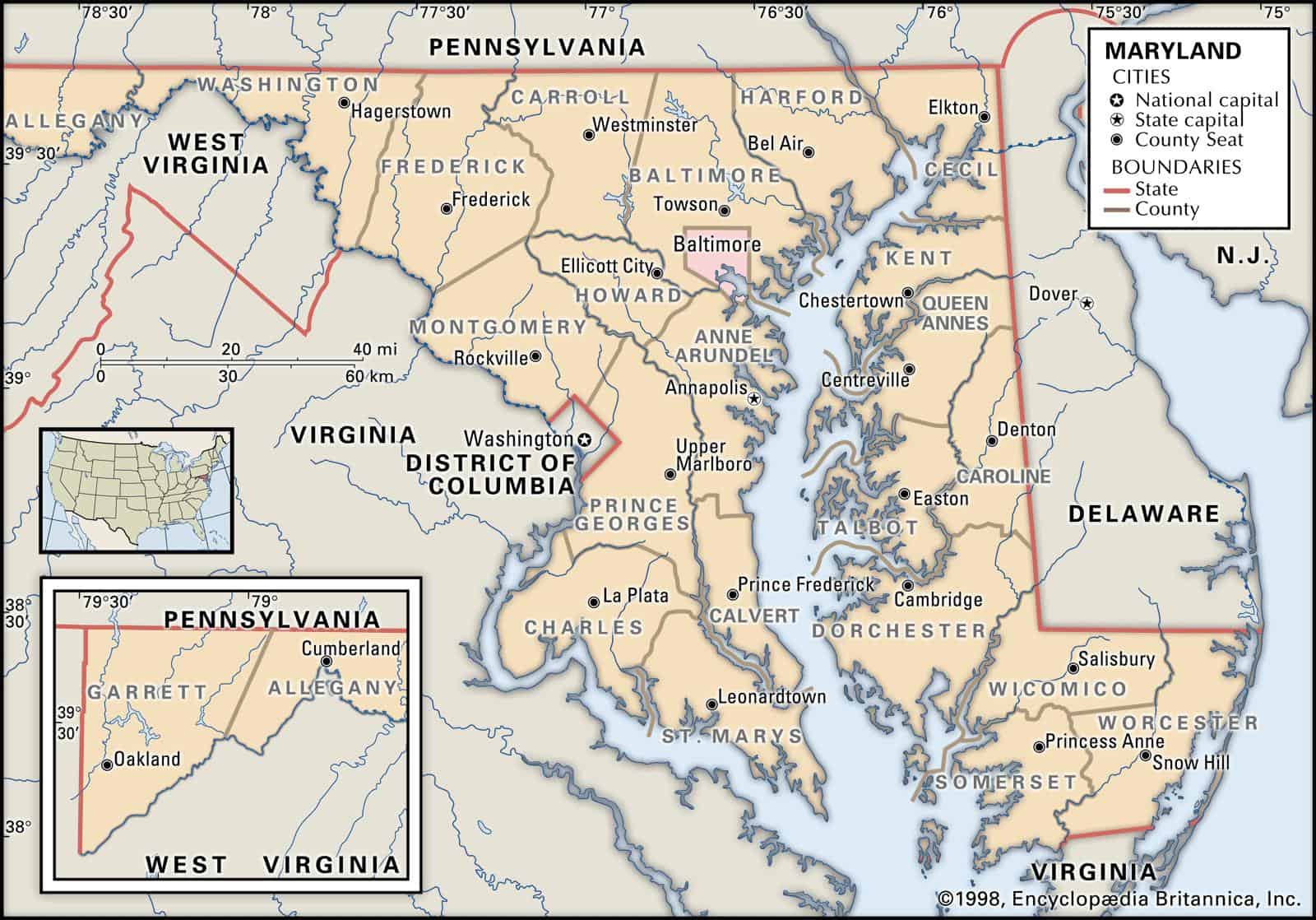
Maps of Maryland are a vital tool when it comes to ancestral and family history research, notably in the event you live far away from where your ancestor lived.
Due to the fact that Maryland’s political borders have often changed over the years, historic maps are critical in helping you find out the precise location of your ancestor’s home, exactly what land they owned, just who their neighbors were, and much more besides.
Maps of Maryland are an outstanding resource to help get you started with your research, given that they provide reliable information and facts in a quick and easily understandable manner.
The largest cities in Maryland are Baltimore, Frederick, Rockville, Gaithersburg, Bowie, Hagerstown, Annapolis, College Park, Salisbury, and Greenbelt.
Learn more historical facts about Maryland counties here.
Interactive Map of Maryland County Formation History
AniMap Plus 3.0, with the permission of the Goldbug Company
Mastering the Map of Maryland
Whether you are tracing your family roots back to the original 17th-century colonies or planning a road trip along the Chesapeake, understanding Maryland’s map takes a bit of strategy. For a state that ranks 42nd in total area, Maryland packs a staggering amount of geographic and historical variety into its borders. From the rugged, mountainous Appalachian panhandle in the west to the flat, marshy Eastern Shore, the Old Line State is split into 23 counties—plus one famously independent city.
If you are looking at a map of Maryland for the first time, you might notice how organic and sometimes chaotic the county borders look. Most of these lines weren’t drawn with a straight ruler in an office; they follow the twists and turns of rivers like the Potomac and the Patuxent, or hug the jagged coastline of the Chesapeake Bay. Because these borders shifted constantly as populations grew between the 1600s and the late 1800s, historic county maps are an absolute lifesaver for pinpointing where historical events actually happened or where old land tracts sat.
Clearing Up Maryland Geography Confusion
Before diving into the full county breakdown, let’s clear up a few common regional mix-ups that often trip up travelers and researchers alike:
- Is Maryland a state or a town? Maryland is officially a U.S. state, though there are small historic villages and unincorporated areas across the world that share the name.
- What county is Baltimore MD in? This is the ultimate Maryland trick question. Baltimore City is an independent city and is completely separate from Baltimore County, which surrounds it. They have separate governments, court systems, and records. If you are tracking down historical records, knowing which one you need is crucial.
- Where is Annapolis County, Maryland? It doesn’t exist! While many people search for “Annapolis County,” Annapolis is actually the state capital and a historic city located inside Anne Arundel County.
- The African Connection: You might occasionally see historical references to “Maryland County joining Liberia.” This refers to an independent republic established by free African Americans and liberated slaves in West Africa in 1834, heavily sponsored by the Maryland State Colonization Society. It officially became a county of Liberia in 1857.
List of Every Maryland County
To help you scan the state quickly, here is a complete, sortable reference table of Maryland’s 23 counties and its single independent city, featuring foundation dates, county seats, and key identifiers.
| County / Entity | County Seat | Established | Origin / History Notes |
|---|---|---|---|
| Allegany County | Cumberland | 1789 | Formed from Washington County; deeply rooted in Appalachian rail and coal history. |
| Anne Arundel County | Annapolis | 1650 | Formed from early plantation lands; home to the state capital and classic Chesapeake boating culture. |
| Baltimore City | — | 1851 | Separated from Baltimore County to become an independent entity; contains dozens of historic urban neighborhoods. |
| Baltimore County | Towson | 1659 | One of the earliest counties; wraps completely around Baltimore City without including it. |
| Calvert County | Prince Frederick | 1654 | A peninsula county bounded by the Patuxent River and the Chesapeake Bay, famous for fossil-rich cliffs. |
| Caroline County | Denton | 1773 | Formed from Dorchester and Queen Anne’s; a landlocked Eastern Shore agricultural hub. |
| Carroll County | Westminster | 1837 | Created from pieces of Baltimore and Frederick counties; dominated by rolling hills and small farm towns. |
| Cecil County | Elkton | 1674 | Sits in the extreme northeast corner of the state, bridging the gap between Maryland, Pennsylvania, and Delaware. |
| Charles County | La Plata | 1658 | Part of Southern Maryland, bordered heavily by the wide Potomac River across from Virginia. |
| Dorchester County | Cambridge | 1668 | The largest county by land area on the Eastern Shore, webbed with rivers, creeks, and historic maritime villages. |
| Frederick County | Frederick | 1748 | Maryland’s largest county by total land area; acts as a bridge between urban centers and the Blue Ridge Mountains. |
| Garrett County | Oakland | 1872 | The westernmost county in Maryland, known for Deep Creek Lake and the state’s highest mountain elevations. |
| Harford County | Bel Air | 1773 | Formed from Baltimore County; stretches from the Susquehanna River down to the edge of the Chesapeake. |
| Howard County | Ellicott City | 1851 | Positioned right between Baltimore and Washington D.C.; famous for the historic mill town of Ellicott City. |
| Kent County | Chestertown | 1642 | One of Maryland’s oldest counties, characterized by historic colonial brick towns along the Chester River. |
| Montgomery County | Rockville | 1776 | Located directly northwest of Washington D.C.; a bustling, diverse hub home to major public assets. |
| Prince George’s County | Upper Marlboro | 1696 | Sits immediately east of Washington D.C.; blends historic rural communities with major waterfront developments. |
| Queen Anne’s County | Centerville | 1706 | Serves as the eastern gateway to the famous Chesapeake Bay Bridge. |
| Somerset County | Princess Anne | 1666 | Located in the southernmost corner of the Eastern Shore; steeped in crabbing, oystering, and skipped-island history. |
| St. Mary’s County | Leonardtown | 1637 | The birthplace of Maryland; where the first English colonists stepped ashore from the Ark and the Dove. |
| Talbot County | Easton | 1662 | An intricate puzzle of peninsulas and historic colonial towns like St. Michaels and Oxford. |
| Washington County | Hagerstown | 1776 | Nests in the narrow “neck” of western Maryland, flanked by the Pennsylvania border and the Potomac River. |
| Wicomico County | Salisbury | 1867 | Formed after the Civil War from Somerset and Worcester pieces; serves as the commercial heart of the Eastern Shore. |
| Worcester County | Snow Hill | 1742 | Maryland’s only county that directly touches the Atlantic Ocean; home to Assateague Island and Ocean City. |
Allegany County
Established in 1789 out of Washington County, Allegany County sits firmly in the mountainous panhandle of Western Maryland. For generations, its borders defined the primary gateway to the American West via the historic National Road and the C&O Canal terminal in Cumberland. Today, it offers a dramatic change of scenery from the rest of the state with its steep ridges and deep valleys.
Anne Arundel County
Founded way back in 1650, Anne Arundel County wraps around the western side of the Chesapeake Bay. It is home to Annapolis, the state capital, which famously boasts more 18th-century brick buildings than any other city in America. The county is defined by its deep sailing heritage, historic maritime ports, and hundreds of miles of tidal shoreline.
Baltimore City
Though frequently confused with its surrounding namesake county, Baltimore City achieved independent status following the adoption of the Maryland Constitution of 1851. It features vibrant inner-harbor waterfronts, historic rows of brick townhouses, and stands completely autonomous from any county jurisdiction.
Baltimore County
Established in 1659, Baltimore County is a massive, horseshoe-shaped region that bounds Baltimore City on three sides and stretches north to the Pennsylvania line. It transitions beautifully from suburban communities to rolling horse country, historic mill towns, and expansive reservoirs.
Calvert County
Calvert County is one of the state’s oldest regions, established in 1654. It forms a narrow peninsula bounded by the slow-moving Patuxent River and the open waters of the Chesapeake Bay. It is highly regarded for the striking Calvert Cliffs, where travelers and researchers routinely hunt for prehistoric shark teeth embedded in the eroding cliffsides.
Caroline County
Created in 1773 right on the border of Delaware, Caroline County is the only landlocked county on Maryland’s Eastern Shore. This gives it a beautifully distinct rural, agricultural feel, dominated by flat farming landscapes, winding creeks, and quiet country backroads.
Carroll County
Carroll County was formed relatively late, in 1837, from parts of Baltimore and Frederick counties. Nestled in the Piedmont region along the Pennsylvania line, its landscape is a picturesque mix of rolling hills, dairy farms, and historic downtowns like Westminster that retain their old-school mid-Atlantic charm.
Cecil County
Shedding its parent counties in 1674, Cecil County anchors the extreme northeast corner of Maryland. It is uniquely positioned where the Susquehanna River meets the tip of the Chesapeake Bay, acting as a historical and modern transport corridor between Baltimore and Philadelphia.
Charles County
Formed in 1658, Charles County sits in Southern Maryland along a wide, dramatic bend of the Potomac River. It blends deep tobacco-growing colonial roots with expansive, protected tidal wetlands, making it a favorite for kayakers and bass fishermen.
Dorchester County
Established in 1668, Dorchester County is the heart and soul of the Eastern Shore’s waterlogged geography. Its intricate network of islands, rivers, and low-lying marshes includes the Blackwater National Wildlife Refuge. It is also deeply significant as the birthplace of Harriet Tubman and a key corridor of the Underground Railroad.
Frederick County
Formed in 1748, Frederick County holds the crown for the largest land area among Maryland’s counties. It features a stunning transition from a bustling, historic downtown area to the rugged ridges of Catoctin Mountain, where covered bridges and apple orchards line the rural routes.
Garrett County
Garrett County is Maryland’s western frontier, established in 1872 as the very last county to be carved out of the state’s territory. Bounded by West Virginia and Pennsylvania, it sits on a high plateau that experiences real, heavy mountain winters. It is a four-season playground home to Deep Creek Lake and Maryland’s highest point, Hoye-Crest.
Harford County
Dating back to 1773, Harford County runs from the rolling hills of the Pennsylvania border down to the upper edges of the Chesapeake Bay. It offers an attractive mix of agricultural valleys, quiet waterfront towns like Havre de Grace, and the expansive wilderness areas along the Susquehanna State Park.
Howard County
Formed in 1851 out of Anne Arundel and Baltimore counties, Howard County occupies a prime piece of real estate in the Piedmont plateau between Washington and Baltimore. It is celebrated for its preservation of historic Ellicott City—a steep, rugged 18th-century mill town built directly onto granite hillsides.
Kent County
Established in 1642, Kent County is the second-oldest county in Maryland. Located on a quiet peninsula on the Eastern Shore, it has intentionally preserved its colonial character, especially in Chestertown, where 18th-century brick mansions still overlook the docks of the Chester River.
Montgomery County
Founded during the Revolutionary era in 1776, Montgomery County sits directly northwest of Washington D.C. Today, it stands as the state’s most populous county, known for major urban centers like Bethesda and Silver Spring. For those looking for a getaway, its northern half transitions into a beautifully preserved agricultural reserve, complete with local farm stands and views of Sugarloaf Mountain.
Prince George’s County
Established in 1696, Prince George’s County curves around the eastern border of Washington D.C. It holds a diverse mix of landscapes, from quiet historic communities like Upper Marlboro to bustling waterfront developments like the National Harbor on the Potomac River. It is a central piece of the state’s economic and cultural engine.
Queen Anne’s County
Formed in 1706, Queen Anne’s County serves as the immediate eastern touchdown point for the iconic Chesapeake Bay Bridge. While its western edge has adapted to travelers heading to the coastal beaches, its interior remains a classic landscape of historic farmsteads, quiet harbors, and water-focused life.
Somerset County
Dating back to 1666, Somerset County is the southernmost county on the Eastern Shore. It is heavily defined by its maritime relationship with the Tangier Sound. Towns like Crisfield are known historically as the “Seafood Capital of the World,” where blue crabbing and oyster harvesting remain a proud way of life.
St. Mary’s County
Established in 1637, St. Mary’s County is where the story of Maryland began. Located on the historic peninsula between the Potomac and Patuxent rivers, it is where early English settlers established the first colonial capital at St. Mary’s City. It offers an incredible concentration of 17th-century historical sites and peaceful coastal country roads.
Talbot County
Formed in 1662, Talbot County is a beautifully fragmented puzzle of long peninsulas, hidden coves, and historic waterfront towns like St. Michaels and Oxford. It features thousands of miles of shoreline, making it one of the premier sailing and historic estate destinations along the mid-Atlantic coast.
Washington County
Founded alongside Montgomery County in 1776, Washington County sits in the narrow mountain limestone valley of western Maryland. Hagerstown serves as its historic hub, while the wider county is stepped in history, containing major Civil War landmarks like the Antietam National Battlefield along the winding Potomac.
Wicomico County
Established in 1867 from pieces of Somerset and Worcester, Wicomico County serves as the regional hub for the Eastern Shore. Its county seat, Salisbury, anchors a landscape that blends extensive agricultural operations with vital river navigation leading straight into the Chesapeake.
Worcester County
Formed in 1742, Worcester County is Maryland’s absolute eastern boundary and its only county with direct frontage on the Atlantic Ocean. It offers a stark geographic contrast between the wild, windswept dunes of Assateague Island, the historic, cypress-lined Pocomoke River swamps, and the bustling boardwalks of Ocean City.
For a deeper look into the evolving timelines and boundaries of these areas, you can explore the rich collection of historical facts about Maryland counties here.
Old Antique Atlases & Maps of Maryland
Disclaimer: All Maryland maps provided or linked on this site are free to use for your own personal genealogical and research purposes. They may not be reproduced for commercial resale or unauthorized distribution.
Historical map collections are an invaluable asset for researchers attempting to locate old family homesteads that have long since been absorbed by modern developments or changing county lines. Excellent digital collections of early plates, land ownership maps, and regional charts can be explored directly through the David Rumsey Historical Map Collection.
D.O.T. County Road and Highway Maps of Maryland
To view detailed regional transport layouts, simply click on the county names below to access the official Department of Transportation maps online. To facilitate fast loading speeds and accessibility on mobile devices, these files have been optimized for web viewing.
- Allegany
- Anne Arundel
- Baltimore
- Calvert
- Caroline
- Carroll
- Cecil
- Charles
- Dorchester
- Frederick
- Garrett
- Harford
- Howard
- Kent
- Montgomery
- Prince George’s
- Queen Anne’s
- Somerset
- St. Mary’s
- Talbot
- Washington
- Wicomico
- Worcester
Maryland Map Links
Expand your exploration of the Old Line State with our companion maps and trusted external archival resources:
- Maryland State Park Map
- Maryland Lakes and Rivers Map
- Maryland Map With Cities and Highways
- Maryland Digital Map Library
- Old Historical Maps of Maryland
- Maryland State Archives Map Collections
- Maryland Maps, Atlases & Gazetteers
- Maryland Maps – The Perry-Castañeda Library Map Collection
- U.S., Indexed County Land Ownership Maps, 1860-1918
- American Memory Map Collection: 1500-2004
- Maryland USGenWeb Archives Digital Map Library
- University Libraries Maryland Map Collection
- The Huntingfield Map Collection
- Maryland Map Books