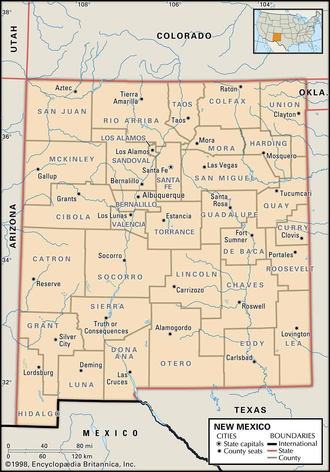
Maps of New Mexico are a crucial element of genealogy and family tree research, especially if you live far away from where your ancestor lived.
Due to the fact that New Mexico’s political borders have often changed throughout the years, historic maps are important in helping you discover the exact location of your ancestor’s hometown, exactly what land they owned, just who their neighbors ended up being, and much more besides.
Maps of New Mexico are an exceptional tool for getting started with your own research, given that they provide substantially important information and facts right away, and then present them in a clearly understandable manner.
New Mexico borders Arizona in the west, Colorado in the north, Oklahoma to the northeast, Texas (east), and Utah (northwest). The 10 largest cities in New Mexico are Albuquerque, Las Cruces, Santa Fe, Rio Rancho, Roswell, Farmington, Clovis, Hobbs, Alamogordo, and Carlsbad.
Learn more historical facts about New Mexico counties here.
Interactive Map of New Mexico County Formation History
AniMap Plus 3.0, with the permission of the Goldbug Company
New Mexico at a Glance: 33 Counties, One Big State
New Mexico has 33 counties — and if you’ve ever tried to look up an ancestor, plan a road trip through the high desert, or just figure out which county Roswell actually sits in, you’ve probably felt the need for a good map. That’s exactly what the interactive tool above is for.
The state borders Arizona to the west, Colorado to the north, Oklahoma to the northeast, Texas to the east, and Utah at its northwest corner. That Four Corners geography shapes everything — the county lines, the cultures, the landscapes, and the reasons people end up here in the first place.
County boundaries in New Mexico have shifted considerably since the territory was organized in the 1850s. Some counties were carved out of older ones, a few were renamed, and at least one — Cibola — wasn’t created until 1981. The interactive map above lets you watch those changes play out over time, which is genuinely useful if you’re doing genealogy research and trying to figure out which county your great-great-grandmother’s land records would have been filed in.
If you want to dig deeper into the historical record, the New Mexico county genealogy resource at RAOGK is a solid starting point.
Major Cities in New Mexico — and Which Counties They Call Home
New Mexico isn’t a state of sprawling metro areas. Outside of Albuquerque — by far the biggest city in New Mexico, with well over half a million residents — most of the state’s cities are mid-sized or small, spread across a lot of open country. That’s part of the appeal, honestly.
Here are the ten largest cities in New Mexico by population, along with the county each one sits in. This matters more than you’d think: county lines affect everything from property taxes to school districts to which courthouse you’d visit for records.
| City | County | Approx. Population | Quick Note |
|---|---|---|---|
| Albuquerque | Bernalillo | ~565,000 | Largest city; sits along the Rio Grande |
| Las Cruces | Doña Ana | ~115,000 | Home to New Mexico State University |
| Rio Rancho | Sandoval | ~107,000 | Fast-growing suburb northwest of Albuquerque |
| Santa Fe | Santa Fe | ~90,000 | State capital; oldest capital city in the US |
| Roswell | Chaves | ~46,000 | Famous for its 1947 UFO incident |
| Farmington | San Juan | ~43,000 | Gateway to the Four Corners region |
| Clovis | Curry | ~40,000 | Eastern plains; near the Texas border |
| Hobbs | Lea | ~40,000 | Oil country in the southeastern corner |
| Alamogordo | Otero | ~32,000 | Near White Sands National Park |
| Carlsbad | Eddy | ~30,000 | Base camp for Carlsbad Caverns |
Population figures are approximate estimates based on recent Census Bureau data and may shift with annual updates.
What’s the nicest city in New Mexico?
That depends a lot on what you’re after. Santa Fe consistently tops travel lists for its arts scene, adobe architecture, and walkable plaza — and it’s genuinely hard to argue with. Taos is smaller but draws a devoted crowd for its pueblo, ski area, and high-desert light that painters have chased for over a century. If you want a real city with great food, live music, and easy access to the Sandia Mountains, Albuquerque makes a strong case. For a quieter pace, smaller cities like Silver City (Grant County) and Truth or Consequences (Sierra County) have developed reputations as offbeat, affordable places to land.
How many cities are in New Mexico?
New Mexico has 101 incorporated municipalities — a mix of cities, towns, and villages. Many of the state’s communities are unincorporated, especially in the rural counties, which means the actual number of named places is considerably higher than that official count suggests.
All 33 New Mexico Counties at a Glance
The table below gives you a fast reference for every county — when it was established, its county seat, and the broad region it sits in. Use it alongside the interactive map above to get your bearings.
| County | County Seat | Est. | Region |
|---|---|---|---|
| Bernalillo | Albuquerque | 1852 | Central |
| Catron | Reserve | 1921 | Southwest |
| Chaves | Roswell | 1889 | Southeast |
| Cibola | Grants | 1981 | West-Central |
| Colfax | Raton | 1869 | Northeast |
| Curry | Clovis | 1909 | East |
| De Baca | Fort Sumner | 1917 | East-Central |
| Doña Ana | Las Cruces | 1852 | South |
| Eddy | Carlsbad | 1889 | Southeast |
| Grant | Silver City | 1868 | Southwest |
| Guadalupe | Santa Rosa | 1891 | East-Central |
| Harding | Mosquero | 1921 | Northeast |
| Hidalgo | Lordsburg | 1919 | Southwest |
| Lea | Lovington | 1917 | Southeast |
| Lincoln | Carrizozo | 1869 | South-Central |
| Los Alamos | Los Alamos | 1949 | North-Central |
| Luna | Deming | 1901 | Southwest |
| McKinley | Gallup | 1901 | Northwest |
| Mora | Mora | 1860 | Northeast |
| Otero | Alamogordo | 1899 | South |
| Quay | Tucumcari | 1903 | East |
| Rio Arriba | Tierra Amarilla | 1852 | North |
| Roosevelt | Portales | 1903 | East |
| San Juan | Aztec | 1887 | Northwest |
| San Miguel | Las Vegas | 1852 | Northeast |
| Sandoval | Bernalillo | 1903 | North-Central |
| Santa Fe | Santa Fe | 1852 | North-Central |
| Sierra | Truth or Consequences | 1884 | Southwest |
| Socorro | Socorro | 1850 | South-Central |
| Taos | Taos | 1852 | North |
| Torrance | Estancia | 1903 | Central |
| Union | Clayton | 1893 | Northeast |
| Valencia | Los Lunas | 1852 | Central |
Every New Mexico County — What Makes Each One Distinct
Thirty-three counties across 121,000 square miles means a lot of variety. Here’s what’s worth knowing about each one.
Bernalillo County
Established in 1852, Bernalillo County is home to Albuquerque — New Mexico’s largest city by a wide margin — and holds about a third of the state’s entire population. The Petroglyph National Monument sits on the city’s west side, and the Sandia Mountains rise dramatically to the east. If you’re trying to understand New Mexico’s geography, Bernalillo is the anchor from which everything else radiates.
Catron County
Founded in 1921, Catron County is the largest county by area in New Mexico — and one of the largest in the contiguous United States — yet fewer than 3,500 people live here. That ratio of land to people is almost hard to picture. The Gila Wilderness, the first designated wilderness area in the US, takes up a big chunk of it. Reserve is the county seat, and it’s a long drive from just about anywhere.
Chaves County
Established in 1889, Chaves County sits in southeastern New Mexico with Roswell as its county seat. The city’s UFO lore from 1947 still drives tourism, but Chaves County is also serious agricultural country — dairy farms, orchards, and pecan groves. Population is around 64,000.
Cibola County
One of the newer counties in the state, Cibola was carved out in 1981 and named for the legendary Seven Cities of Gold that Spanish explorers searched for in the 1500s. It covers parts of the Cibola National Forest and El Malpais National Monument, a striking landscape of lava flows and sandstone bluffs near Grants. Population is roughly 27,000.
Colfax County
Established in 1869, Colfax County occupies the northeastern corner of New Mexico where the Sangre de Cristo Mountains begin to flatten into the Great Plains. The historic town of Cimarron was a stop on the Santa Fe Trail and has the kind of Old West atmosphere that doesn’t feel manufactured. Parts of the Carson National Forest fall within its borders. Population is around 12,000.
Curry County
Founded in 1909, Curry County is eastern New Mexico plains country — flat, windy, and agricultural. Clovis is the county seat and the largest city in the eastern part of the state. The county also contains parts of the Kiowa National Grassland. Population is approximately 48,000.
De Baca County
Established in 1917, De Baca County is one of the smallest counties in New Mexico by population — around 1,800 residents — and one of the quietest. Fort Sumner, the county seat, is where Billy the Kid is buried, which draws a steady trickle of visitors to an otherwise very rural stretch of the Pecos River valley.
Doña Ana County
Founded in 1852, Doña Ana County anchors the southern end of the state with Las Cruces as its county seat. New Mexico State University is here, as are parts of the Organ Mountains-Desert Peaks National Monument — a dramatic range that rises abruptly from the Chihuahuan Desert. Population is around 217,000, making it the second most populous county in the state.
Eddy County
Established in 1889, Eddy County is in the southeastern corner of New Mexico and contains Carlsbad Caverns National Park — one of the most visited sites in the state. The county’s economy runs heavily on oil, gas, and potash mining. Carlsbad is the county seat; population is around 59,000.
Grant County
Founded in 1868, Grant County is in the rugged southwest corner of the state. Silver City is the county seat and has become a genuine arts and outdoor recreation destination. The Gila National Forest and the Gila Cliff Dwellings National Monument are the big draws. Population is around 27,000.
Guadalupe County
Established in 1891, Guadalupe County sits in east-central New Mexico along the Pecos River. Santa Rosa is the county seat and is known for its natural lakes — the Blue Hole in particular draws scuba divers from across the region. Population is around 4,400.
Harding County
Established in 1921, Harding County is one of the least populated counties in the entire United States, with roughly 700 residents spread across nearly 2,200 square miles of northeastern New Mexico grassland. Mosquero is the county seat. If you’re looking for solitude and big sky, it’s hard to beat.
Hidalgo County
Established in 1919, Hidalgo County occupies the far southwestern corner of New Mexico, bordering both Arizona and Mexico. Lordsburg is the county seat. The Peloncillo Mountains run through the county, and the Gila Wilderness is nearby. Population is around 4,500.
Lea County
Founded in 1917, Lea County is oil country — one of the most productive petroleum-producing counties in New Mexico. Lovington is the county seat; Hobbs is the largest city. The county sits in the southeastern corner, right on the Texas border. Population is around 72,000.
Lincoln County
Established in 1869, Lincoln County is famous for its role in the Lincoln County War of the late 1870s — the conflict that made Billy the Kid notorious. The historic town of Lincoln is preserved almost exactly as it was. Carrizozo is the county seat. Population is around 20,000.
Los Alamos County
Established in 1949, Los Alamos County is one of the smallest counties in New Mexico by both area and population (around 19,000 residents), but it punches well above its weight. The Los Alamos National Laboratory, where the atomic bomb was developed during World War II, is still one of the most significant research institutions in the country. It’s also, by most measures, the wealthiest county per capita in New Mexico.
Luna County
Established in 1901, Luna County is in the southwestern corner of the state with Deming as its county seat. The Chihuahuan Desert dominates the landscape. Population is around 24,000. Deming is known for its annual Duck Race, which is exactly as charming as it sounds.
McKinley County
Founded in 1901, McKinley County is in northwestern New Mexico and contains parts of both the Navajo Nation and Zuni Pueblo — making it one of the most culturally significant counties in the state. Gallup is the county seat and a major trading center for Native American arts and crafts. Population is around 71,000.
Mora County
Established in 1860, Mora County is in northeastern New Mexico in the foothills of the Sangre de Cristo Mountains. The Mora Valley is scenic and historically significant as a Spanish colonial settlement area. Parts of the Santa Fe National Forest fall within the county. Population is around 5,000.
Otero County
Established in 1899, Otero County is in southern New Mexico and contains White Sands National Park — the world’s largest gypsum dune field — as well as Holloman Air Force Base and the White Sands Missile Range. Alamogordo is the county seat. Population is around 67,000.
Quay County
Founded in 1903, Quay County is in eastern New Mexico on the edge of the Great Plains. Tucumcari is the county seat and a classic Route 66 town — the kind of place with neon motel signs and murals that make you want to slow down. Population is around 8,300.
Rio Arriba County
Established in 1852, Rio Arriba County is in northern New Mexico and contains some of the state’s most storied landscapes — the Chimayó and Abiquiú historic districts, Ghost Ranch (where Georgia O’Keeffe painted for decades), and the Río Chama canyon. Tierra Amarilla is the county seat. Population is around 40,000.
Roosevelt County
Founded in 1903, Roosevelt County is in the eastern plains with Portales as its county seat. Eastern New Mexico University is located here. The county is primarily agricultural — peanuts, dairy, and cattle. Population is around 20,000.
San Juan County
Established in 1887, San Juan County is in the Four Corners region of northwestern New Mexico. Aztec is the county seat; Farmington is the largest city. The Chaco Culture National Historical Park — a UNESCO World Heritage Site — is within the county, as is the Bisti/De-Na-Zin Wilderness, a surreal badlands landscape. Population is around 128,000.
San Miguel County
Established in 1852, San Miguel County is in northeastern New Mexico with Las Vegas (New Mexico’s Las Vegas, not Nevada’s) as its county seat. The town has a remarkably intact Victorian-era downtown and a plaza that predates the American period. The historic town of Pecos and Pecos National Historical Park are also here. Population is around 27,000.
Sandoval County
Founded in 1903, Sandoval County wraps around the north and west sides of Albuquerque and includes the fast-growing city of Rio Rancho. The Jemez Mountains, Valles Caldera National Preserve, and several pueblo communities are within its borders. Population is around 150,000.
Santa Fe County
Established in 1852, Santa Fe County is home to the state capital — Santa Fe — which is also the oldest state capital in the United States. The Palace of the Governors on the plaza has been in continuous use since 1610. The county draws enormous tourism and arts activity. Population is around 150,000.
Sierra County
Founded in 1884, Sierra County is in southwestern New Mexico with Truth or Consequences as its county seat — a town that literally changed its name from Hot Springs in 1950 to win a radio show contest. Elephant Butte Lake State Park, one of the largest reservoirs in New Mexico, is a major draw. The Geronimo Trail National Scenic Byway runs through the county. Population is around 11,000.
Socorro County
Established in 1850, Socorro County is in south-central New Mexico and is one of the older organized counties in the state. The Bosque del Apache National Wildlife Refuge — famous for its winter sandhill crane and snow goose migrations — is here, as is the Very Large Array radio telescope. Socorro is the county seat. Population is around 17,000.
Taos County
Established in 1852, Taos County is in northern New Mexico and is one of the most visited counties in the state. Taos Pueblo, a UNESCO World Heritage Site and one of the oldest continuously inhabited communities in North America, is here. Wheeler Peak — the highest point in New Mexico at 13,161 feet — is in the Wheeler Peak Wilderness within the county. Population is around 33,000.
Torrance County
Founded in 1903, Torrance County is in central New Mexico with Estancia as its county seat. The Estancia Valley is known for its pinto bean farming and salt lakes. It’s a quiet, agricultural county that often gets overlooked on the way between Albuquerque and the eastern plains. Population is around 16,000.
Union County
Established in 1893, Union County is in the far northeastern corner of New Mexico where the Sangre de Cristo Mountains give way to the Great Plains. Clayton is the county seat. The area has significant dinosaur track sites and sits along the Dry Cimarron River. Population is around 4,000.
Valencia County
Established in 1852, Valencia County is directly south of Bernalillo County along the Rio Grande. Los Lunas is the county seat. The county is one of the original four counties organized when New Mexico became a US territory, and it has a long history of Spanish colonial settlement in the Rio Abajo (lower river) region. Population is around 76,000.
Old Antique Atlases & Maps of New Mexico
If you’re doing genealogy research or just enjoy watching how county lines shifted over time, historical maps are invaluable. The David Rumsey Historical Map Collection has an excellent archive of New Mexico maps going back centuries.
A few specific historical maps worth exploring:
- 1856 Territories of New Mexico and Utah Atlas Map — shows the territorial boundaries before statehood
- 1866 Sketch of Public Surveys in New Mexico & Arizona — useful for land ownership research
- 1880 County Map of Arizona and New Mexico — shows how dramatically county lines have changed
- 1852 map of Santa Ana County — an early look at the original territorial county organization
The New Mexico Digital Map Library and the Perry-Castañeda Library Map Collection at UT Austin are also well worth bookmarking for deeper research.
More New Mexico Map Resources
Looking for a specific type of New Mexico map? Here are some useful starting points:
- New Mexico State Park Map
- New Mexico Lakes and Rivers Map
- New Mexico Map With Cities and Highways
- New Mexico Digital Map Library
- Old Historical Maps of New Mexico
- New Mexico Maps — Perry-Castañeda Library Map Collection
- American Memory Map Collection: 1500–2004 (Library of Congress)
For neighboring states, the county map pages for Arizona, Colorado, Texas, and Utah follow the same format and are useful for cross-border research.