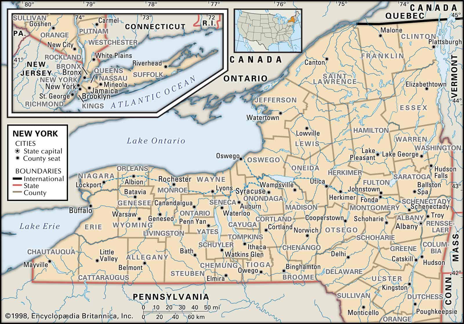
Maps of New York are a very helpful tool when it comes to family history research, especially if you live far away from where your ancestor was living.
Due to the fact that political borders in the United States have often changed over the years, historic maps are important in helping you uncover the precise location of your ancestor’s hometown, just what land they owned, exactly who his or her neighbors were, and much more besides.
Maps of New York are an exceptional source for getting started with your research, given that they give important information and facts quickly about boundaries, rivers, and state borders, and then present them in a clearly understandable format.
The 10 largest cities in New York are New York City, Buffalo, Rochester, Yonkers, Syracuse, Albany, New Rochelle, Mount Vernon, Schenectady, and Utica.
Learn more historical facts about New York counties here.
Interactive Map of New York County Formation History
AniMap Plus 3.0, with the permission of the Goldbug Company
Quick Answers: New York County Questions People Actually Ask
What county is New York City in?
New York City is actually spread across five separate counties, which is part of what makes it unlike any other city in the US. Those five counties are New York County (Manhattan), Kings County (Brooklyn), Queens County, Bronx County, and Richmond County (Staten Island). Each borough is its own county, which is why you’ll sometimes see legal documents or older maps refer to Brooklyn as Kings County or Staten Island as Richmond County.
Is Manhattan called New York County?
Yes — Manhattan and New York County are the same place. The borough of Manhattan is coterminous with New York County, meaning the borough boundaries and the county boundaries are identical. It’s one of those geographic quirks that trips people up constantly. When someone asks “what county is Harlem in,” the answer is New York County, because Harlem is a neighborhood within Manhattan.
What are the five counties of New York City?
The five NYC counties are New York (Manhattan), Kings (Brooklyn), Queens, Bronx, and Richmond (Staten Island). They were consolidated into a single city government in 1898, but each retained its county identity. Queens County and Kings County are actually two of the most populous counties in the entire United States.
What are the 12 original counties of New York?
When the English colonial government organized New York in 1683, twelve counties were established: Albany, Cornwall (later renamed Orange), Dukes, Dutchess, Kings, New York, Queens, Richmond, Suffolk, Ulster, Westchester, and Yorkshire. Several of those original counties have since been split, renamed, or had their boundaries dramatically redrawn — which is exactly what the interactive map above is so useful for tracing. Dukes County, for instance, eventually became part of Massachusetts. Yorkshire was divided into multiple counties. The 1683 map of New York looks almost nothing like the 62-county map you see today.
New York’s Counties by Region
New York’s 62 counties span an enormous range of geography — from the dense urban grid of Manhattan to the nearly empty Adirondack wilderness of Hamilton County, which has roughly 4,500 residents and is one of the least populous counties in the entire country. To make sense of the map, it helps to think in regions.
| Region | Counties | Geographic Character |
|---|---|---|
| New York City | Bronx, Kings, New York, Queens, Richmond | Five boroughs, five counties — the most densely populated corner of the state by a wide margin |
| Hudson Valley & NYC Metro | Dutchess, Orange, Putnam, Rockland, Sullivan, Ulster, Westchester | The counties that ring the city to the north and west; Rockland County sits just across the Hudson from Westchester, with the Tappan Zee (Mario Cuomo) Bridge connecting them |
| Long Island | Nassau, Suffolk | Two counties covering all of Long Island east of the city; Nassau is dense suburban, Suffolk stretches out to the Hamptons and the North Fork |
| Capital Region | Albany, Columbia, Greene, Montgomery, Rensselaer, Saratoga, Schenectady, Schoharie, Warren, Washington | The historic heart of the state, anchored by Albany and the upper Hudson Valley; Saratoga is famous for its racetrack and Revolutionary War battlefield |
| North Country & Adirondacks | Clinton, Essex, Franklin, Fulton, Hamilton, Herkimer, Jefferson, Lewis, Oswego, St. Lawrence | Vast, lightly populated, and bordered by Canada and Lake Ontario; Essex County contains the High Peaks of the Adirondacks, including Mount Marcy |
| Central New York | Chenango, Cortland, Madison, Oneida, Onondaga, Otsego | Syracuse anchors Onondaga County; Otsego County is home to Cooperstown and the Baseball Hall of Fame |
| Finger Lakes | Cayuga, Livingston, Monroe, Ontario, Schuyler, Seneca, Steuben, Tompkins, Wayne, Yates | Eleven long, narrow lakes carved by glaciers; Monroe County (Rochester) is the region’s urban center, while Tompkins County is home to Ithaca and Cornell University |
| Southern Tier | Broome, Chemung, Delaware, Tioga | The counties that border Pennsylvania, Broome County (Binghamton) and Chemung County (Elmira), are the main population centers along the Susquehanna River corridor |
| Western New York | Allegany, Cattaraugus, Chautauqua, Erie, Genesee, Niagara, Orleans, Wyoming | Erie County (Buffalo) and Niagara County anchor the western edge; Chautauqua County reaches the shores of Lake Erie; Niagara Falls straddles the county line between Niagara County and Canada |
List of Every New York County
New York has 62 counties in total. Here’s the complete list with founding dates, county seats, and a note on what makes each one worth knowing.
Albany County
Established in 1683, Albany County is one of the original twelve and is home to the state capital. The city of Albany sits on the west bank of the Hudson River and has been the seat of state government since 1797. Population: approximately 305,000.
Allegany County
Founded in 1806, Allegany County occupies the southwestern corner of the state along the Pennsylvania border. The county seat is Belmont, and the Allegany State Park — the largest state park in New York — covers a big chunk of the county’s southern edge. Population: approximately 46,000.
Bronx County
Established in 1914, Bronx County is the only New York City borough located on the mainland of North America. It’s the youngest of the five NYC counties and home to Yankee Stadium, the New York Botanical Garden, and the Bronx Zoo. Population: approximately 1.4 million.
Broome County
Founded in 1806, Broome County sits in the Southern Tier along the Susquehanna River, right at the Pennsylvania state line. The county seat is Binghamton. Population: approximately 191,000.
Cattaraugus County
Established in 1808, Cattaraugus County is in southwestern New York and includes the Allegany Reservation of the Seneca Nation. The county seat is Little Valley. Population: approximately 76,000.
Cayuga County
Established in 1799, Cayuga County sits in the Finger Lakes region along the shores of Cayuga Lake — the longest of the Finger Lakes. The county seat is Auburn. Population: approximately 76,000.
Chautauqua County
Founded in 1808, Chautauqua County is the westernmost county in New York, touching Lake Erie. It’s known for the Chautauqua Institution, a summer learning community that’s been running since 1874. The county seat is Mayville. Population: approximately 126,000.
Chemung County
Established in 1836, Chemung County is in the Southern Tier with Elmira as its county seat. Mark Twain spent his summers in Elmira and is buried there. Population: approximately 83,000.
Chenango County
Founded in 1798, Chenango County is in central New York with Norwich as its county seat. It’s quiet, rural, and sits at the headwaters of the Chenango River. Population: approximately 47,000.
Clinton County
Established in 1788, Clinton County is in the far northeastern corner of the state, bordering Vermont and Canada. Plattsburgh is the county seat and sits on the western shore of Lake Champlain. Population: approximately 81,000.
Columbia County
Founded in 1786, Columbia County is in the Hudson Valley with Hudson as its county seat. The city of Hudson has become a destination for antique shops, restaurants, and weekend visitors from New York City. Population: approximately 59,000.
Cortland County
Established in 1808, Cortland County is in central New York. The county seat is Cortland, home to SUNY Cortland. Population: approximately 47,000.
Delaware County
Founded in 1797, Delaware County is in the Catskill Mountains with Delhi as its county seat. It’s one of the larger counties by area in the state but sparsely populated, with a lot of state forest land and reservoir watershed. Population: approximately 44,000.
Dutchess County
One of the original 1683 counties, Dutchess County is in the Hudson Valley with Poughkeepsie as its county seat. The county is home to the Culinary Institute of America and a stretch of the Hudson River that includes Hyde Park, Franklin Roosevelt’s home. Population: approximately 295,000.
Erie County
Founded in 1821, Erie County is anchored by Buffalo, the state’s second-largest city. The county sits at the eastern end of Lake Erie and the head of the Niagara River. Population: approximately 920,000.
Essex County
Established in 1799, Essex County covers a large swath of the Adirondack High Peaks. Lake Placid — host of the 1932 and 1980 Winter Olympics — is here, along with Mount Marcy, the highest point in New York. The county seat is Elizabethtown. Population: approximately 36,000.
Franklin County
Founded in 1808, Franklin County is in the North Country along the Canadian border. Malone is the county seat. The county includes part of the St. Regis Mohawk Reservation and a lot of Adirondack Park land. Population: approximately 50,000.
Fulton County
Established in 1838, Fulton County is in the southern Adirondacks with Johnstown as its county seat. The Sacandaga Reservoir (Great Sacandaga Lake) is a major geographic feature. Population: approximately 53,000.
Genesee County
Founded in 1802, Genesee County is in western New York with Batavia as its county seat. It’s largely agricultural, sitting in the flat lake plain between Rochester and Buffalo. Population: approximately 57,000.
Greene County
Established in 1800, Greene County is in the Catskill Mountains on the west bank of the Hudson River. Catskill is the county seat. The county includes Kaaterskill Falls and the ski areas of Hunter and Windham. Population: approximately 47,000.
Hamilton County
Founded in 1816, Hamilton County is the least populous county in New York — and one of the least populous in the entire United States, with around 4,500 residents. It’s almost entirely within the Adirondack Park. The county seat is Lake Pleasant. If you’re looking for genuine wilderness in New York, this is it.
Herkimer County
Established in 1791, Herkimer County is in central New York along the Mohawk River valley. The county seat is Herkimer. The county is known for “Herkimer diamonds” — actually double-terminated quartz crystals found in the local dolomite. Population: approximately 61,000.
Jefferson County
Founded in 1805, Jefferson County is in northern New York on the eastern shore of Lake Ontario, with Watertown as its county seat. Fort Drum, a major US Army installation, is located here. The Thousand Islands region begins at the county’s northern edge. Population: approximately 110,000.
Kings County (Brooklyn)
Established in 1683, Kings County is coterminous with the borough of Brooklyn. It’s the most populous county in New York State and one of the most densely populated counties in the country. The county seat is Brooklyn. Population: over 2.5 million.
Lewis County
Founded in 1805, Lewis County is in the North Country between the Adirondacks and the Tug Hill Plateau — an area that gets some of the heaviest lake-effect snowfall in the eastern US. The county seat is Lowville. Population: approximately 26,000.
Livingston County
Established in 1821, Livingston County is in western New York with Geneseo as its county seat. The Genesee River runs through the county, and Letchworth State Park — sometimes called the “Grand Canyon of the East” — is here. Population: approximately 63,000.
Madison County
Founded in 1806, Madison County is in central New York with Wampsville as its county seat. Cazenovia and Oneida are the better-known towns. Population: approximately 71,000.
Monroe County
Established in 1821, Monroe County is anchored by Rochester, the third-largest city in New York. The county sits on the southern shore of Lake Ontario. Rochester was a center of the abolitionist movement and home to Frederick Douglass and Susan B. Anthony. Population: over 741,000.
Montgomery County
Founded in 1772 (as Tryon County, renamed after the Revolution), Montgomery County is in the Mohawk Valley with Fonda as its county seat. It’s one of the oldest counties in the state and saw significant Revolutionary War action. Population: approximately 49,000.
Nassau County
Established in 1899, Nassau County is the first county you hit heading east from New York City on Long Island. The county seat is Mineola. Nassau is one of the most densely populated suburban counties in the country. Population: over 1.3 million.
New York County (Manhattan)
Founded in 1683, New York County is coterminous with the borough of Manhattan. It’s the economic and cultural center of the city and home to neighborhoods ranging from the Financial District and Tribeca to Midtown, the Upper West Side, and Harlem in the northern part of the island. The county seat is New York City. Population: approximately 1.6 million.
Niagara County
Established in 1808, Niagara County is in western New York along the Niagara River and Lake Ontario. Lockport is the county seat. Niagara Falls — the city — is in the county, and the falls themselves sit on the international border with Canada. Population: approximately 209,000.
Oneida County
Founded in 1798, Oneida County is in central New York with Utica as its county seat. The county has a significant refugee resettlement community and is known for its Bosnian and Somali immigrant populations who have revitalized parts of Utica. Population: over 229,000.
Onondaga County
Established in 1794, Onondaga County is home to Syracuse, the largest city in central New York. The county sits at the crossroads of I-81 and I-90. The Onondaga Nation, one of the six nations of the Haudenosaunee Confederacy, has territory within the county. Population: over 460,000.
Ontario County
Founded in 1789, Ontario County is in the Finger Lakes region with Canandaigua as its county seat. Canandaigua Lake is one of the most scenic of the Finger Lakes. Population: approximately 109,000.
Orange County
Established in 1683 as Cornwall County and renamed in 1683, Orange County is in the Hudson Valley with Goshen as its county seat. The county borders New Jersey and Pennsylvania and includes West Point and the Hudson Highlands. Population: over 385,000.
Orleans County
Founded in 1824, Orleans County is a narrow strip along the Lake Ontario shoreline in western New York. Albion is the county seat. The county is known for apple orchards and the Erie Canal corridor. Population: approximately 40,000.
Oswego County
Established in 1816, Oswego County is on the eastern shore of Lake Ontario with Oswego as its county seat. The Port of Oswego is the only international port of entry on Lake Ontario in New York. Population: approximately 116,000.
Otsego County
Founded in 1791, Otsego County is in central New York with Cooperstown as its county seat. Cooperstown sits at the southern tip of Otsego Lake and is home to the National Baseball Hall of Fame. Population: approximately 59,000.
Putnam County
Established in 1812, Putnam County is in the Hudson Valley between Westchester and Dutchess counties. Carmel is the county seat. The county is largely suburban and exurban, with a lot of reservoir land that supplies New York City’s water. Population: approximately 98,000.
Queens County
Founded in 1683, Queens County is coterminous with the borough of Queens. It’s the most ethnically diverse county in the United States — and arguably the most diverse urban area on earth. JFK International Airport and LaGuardia Airport are both in Queens. Population: over 2.3 million.
Rensselaer County
Established in 1791, Rensselaer County is directly across the Hudson River from Albany, with Troy as its county seat. Troy was a major industrial city in the 19th century and is experiencing a significant revival. Population: approximately 159,000.
Richmond County (Staten Island)
Founded in 1683, Richmond County is coterminous with the borough of Staten Island. It’s the least densely populated of the five NYC boroughs and the only one not connected to Manhattan by subway. The Staten Island Ferry provides free transit across New York Harbor. Population: approximately 476,000.
Rockland County
Established in 1798, Rockland County sits on the west bank of the Hudson River, directly across from Westchester County and bordering New Jersey to the south. Nyack is one of the better-known towns; New City is the county seat. Rockland is part of the greater New York City metropolitan area and is one of the most densely populated counties in the state outside the five boroughs. Population: over 328,000.
St. Lawrence County
Founded in 1802, St. Lawrence County is the largest county by area in New York State. It borders Canada along the St. Lawrence River and Lake Ontario. Canton is the county seat. The county is home to SUNY Canton and Clarkson University. Population: approximately 107,000.
Saratoga County
Established in 1791, Saratoga County is in eastern New York with Ballston Spa as the county seat (though Saratoga Springs is the best-known city). The Saratoga Race Course is the oldest continuously operating thoroughbred racetrack in the US. The Saratoga National Historical Park preserves the site of the 1777 Battle of Saratoga, a turning point in the Revolutionary War. Population: approximately 245,000.
Schenectady County
Founded in 1809, Schenectady County is in eastern New York with Schenectady as its county seat. The city was a major center for General Electric and the American Locomotive Company. Population: approximately 156,000.
Schoharie County
Established in 1795, Schoharie County is in eastern New York with Schoharie as its county seat. The county sits in a valley between the Catskills and the Helderberg Escarpment. Population: approximately 30,000.
Schuyler County
Founded in 1854, Schuyler County is in the Finger Lakes region with Watkins Glen as its county seat. Watkins Glen State Park, at the southern tip of Seneca Lake, is one of the most visited state parks in New York. Population: approximately 17,000.
Seneca County
Established in 1804, Seneca County sits between Cayuga and Seneca lakes in the Finger Lakes region. Waterloo is the county seat and is recognized as the birthplace of Memorial Day. Population: approximately 34,000.
Steuben County
Founded in 1796, Steuben County is in the Southern Tier along the Pennsylvania border with Corning as its most prominent city (Bath is the county seat). The Corning Museum of Glass draws visitors from across the country. Population: approximately 95,000.
Suffolk County
Established in 1683, Suffolk County covers the eastern two-thirds of Long Island. The county seat is Riverhead. Suffolk stretches from the dense suburbs of western Long Island to the Hamptons, the North Fork wine country, and Montauk at the island’s eastern tip. Population: approximately 1.4 million.
Sullivan County
Founded in 1809, Sullivan County is in the Catskill Mountains with Monticello as its county seat. The county was the heart of the Borscht Belt resort era in the mid-20th century; Bethel Woods, site of the 1969 Woodstock festival, is here. Population: approximately 76,000.
Tioga County
Established in 1791, Tioga County is in the Southern Tier along the Pennsylvania border with Owego as its county seat. The county is largely rural and sits in the Susquehanna River valley. Population: approximately 48,000.
Tompkins County
Founded in 1817, Tompkins County is in the Finger Lakes region with Ithaca as its county seat. Cornell University and Ithaca College are both here, and the gorges and waterfalls around Ithaca are genuinely spectacular. Population: approximately 105,000.
Ulster County
Established in 1683, Ulster County is one of the original twelve and sits in the Hudson Valley with Kingston as its county seat. Kingston was briefly the state capital during the Revolution. The county includes the Catskill Mountains, Woodstock, and the Ashokan Reservoir. Population: approximately 179,000.
Warren County
Founded in 1813, Warren County is in the eastern Adirondacks with Lake George as its most famous destination (Queensbury is the county seat). Lake George Village draws summer tourists, and the southern Adirondacks offer year-round outdoor recreation. Population: approximately 64,000.
Washington County
Established in 1772 (as Charlotte County, renamed after the Revolution), Washington County is in eastern New York along the Vermont border with Fort Edward as its county seat. The county includes part of Lake Champlain’s western shore. Population: approximately 60,000.
Wayne County
Founded in 1823, Wayne County is on the southern shore of Lake Ontario between Rochester and Syracuse, with Lyons as its county seat. The county is known for apple and cherry orchards along the lake plain. Population: approximately 91,000.
Westchester County
Established in 1683, Westchester County is directly north of New York City and is one of the most recognizable county names in the state. White Plains is the county seat, and Westchester County Airport (HPN) is located there — a convenient regional airport for travelers who want to avoid the major NYC airports. The county includes communities like Yonkers, New Rochelle, Mount Vernon, and the village of Tarrytown along the Hudson. Westchester is part of the greater New York City metropolitan area and consistently ranks among the wealthiest counties in the United States. Population: over 970,000.
Wyoming County
Founded in 1841, Wyoming County is in western New York with Warsaw as its county seat. It’s a rural agricultural county between Genesee and Livingston counties. Population: approximately 39,000.
Yates County
Established in 1823, Yates County is the smallest county in New York by area and sits between Seneca and Keuka lakes in the Finger Lakes region. Penn Yan is the county seat. The county is known for its wine trails and Mennonite farming communities. Population: approximately 25,000.
How New York’s County Map Changed Over Time
One of the most interesting things about New York’s county map is how much it has shifted over the centuries. The interactive map at the top of this page lets you watch that evolution play out — counties splitting, being renamed, and having their borders redrawn as population moved and political priorities changed.
The original 1683 counties were enormous by today’s standards. Albany County, for instance, once covered most of what is now upstate New York. As settlers pushed north and west, the legislature carved out new counties to bring government closer to local populations. By the early 1800s, the county-formation pace was rapid — many of the Finger Lakes and western New York counties were created between 1789 and 1830.
The last county created in New York was Bronx County in 1914, carved out of Westchester County after the Bronx was annexed into New York City. Since then, the map has been stable — 62 counties, unchanged for over a century.
If you’re researching family history in New York, this history matters a lot. A deed or census record from 1810 might list a county that no longer exists or that covered a completely different area than the county with the same name today. The historical maps in our atlas collection are particularly useful for this kind of research.
Historical Maps of New York
New York has one of the richest collections of historical cartography of any state. Here are some of the maps in our atlas collection that are worth exploring alongside the interactive county formation tool:
- 1776: The Provinces of New York and New Jersey, with part of Pennsylvania — shows the colonial-era county structure before the Revolution reshaped the map
- 1795 Map of New York — the state just over a decade after independence, with the early county grid taking shape
- 1804 Atlas Map of New York
- 1814 Atlas Map of New York
- 1822 Geographical, Historical, and Statistical Atlas Map of New York
- 1827 Map of New York
- 1836 New Atlas Map of New York with its Canals, Roads & Distances — particularly useful for understanding the Erie Canal era and how it shaped county development
- 1845 Map of New York
- 1856 Map of New York
- 1880 County Map of New York State — includes inset maps of Buffalo, Rochester, Troy, Albany, and New York Harbor
- 1880 Map of New York City and Brooklyn