
Maps of Maine are an invaluable area of family history research, notably in the case that you live far from where your ancestor resided.
Since Maine’s political boundaries have often changed over the years, historic maps are important when it comes to discovering the exact location of your ancestor’s hometown, what land they owned, just who their neighbors were, and much more besides.
Maps of Maine are an excellent resource for getting started with your own research, given that they provide valuable information and facts instantly, and then present them in a clear and understandable format.
The largest cities in Maine are Portland, Lewiston, Bangor, South Portland, Auburn, Biddeford, Sanford, Brunswick, Augusta, and Scarborough.
Learn more historical facts about Maine counties here.
Interactive Map of Maine County Formation History
AniMap Plus 3.0, with the permission of the Goldbug Company
List of Every Maine County
Androscoggin County
Established in 1854, Androscoggin County has a population of approximately 108,000. The county seat is Auburn and the largest city is Lewiston. It is named after the Androscoggin River.
Aroostook County
Aroostook County is the largest county in Maine, with a population of around 67,000. It was established in 1839 and its county seat is Houlton. The county is known for its vast forests and potato fields.
Cumberland County
With approximately 295,000 residents, Cumberland County is Maine’s most populous county. It was founded in 1760 and its county seat is Portland, the largest city in Maine.
Franklin County
Established in 1838, Franklin County is home to around 29,000 people. Its county seat is Farmington, a small college town. The county is celebrated for its scenic beauty and outdoor recreation opportunities.
Hancock County
Hancock County was founded in 1789 and has a population of approximately 54,000. Its county seat is Ellsworth and the largest city is Bar Harbor, a popular tourist destination on Mount Desert Island.
Kennebec County
Kennebec County is home to around 122,000 people and was founded in 1799. Its county seat is Augusta, the state capital, and the largest city is Waterville. The county contains many historic sites, including the Old Fort Western.
Knox County
Established in 1860, Knox County has a population of approximately 39,000. Its county seat is Rockland, a coastal city famous for its lobster festival. The county is also home to many historic lighthouses.
Lincoln County
Lincoln County was founded in 1760 and has around 34,000 residents. Its county seat is Wiscasset, a historic town on the Sheepscot River. The county is much loved for its coastal villages and maritime heritage.
Oxford County
With a population of approximately 57,000, Oxford County was established in 1805. Its county seat is Paris and the largest city is Norway. The county is home to many ski resorts and outdoor recreation opportunities.
Penobscot County
Penobscot County has a population of around 152,000 and was founded in 1816. Its county seat is Bangor, the third-largest city in Maine. The county is valued for its natural beauty and is home to Baxter State Park and the Penobscot River.
Piscataquis County
Established in 1838, Piscataquis County has around 16,000 residents. Its county seat is Dover-Foxcroft, a small town on the Piscataquis River. The county is notable for its wilderness areas and outdoor recreation opportunities.
Sagadahoc County
Sagadahoc County was founded in 1854 and has a population of approximately 36,000. Its county seat is Bath, a historic shipbuilding city on the Kennebec River. The county is also home to the Popham Beach State Park.
Somerset County
Somerset County is home to around 51,000 people and was established in 1809. Its county seat is Skowhegan, a town on the Kennebec River. The county is celebrated for its lakes and rivers, including Moosehead Lake and the Kennebec River.
Waldo County
Established in 1827, Waldo County has a population of approximately 40,000. Its county seat is Belfast, a coastal city known for its art galleries and seafood restaurants. The county is also home to Penobscot Bay.
Washington County
Washington County is the easternmost county in Maine, with a population of around 31,000. It was established in 1789 and its county seat is Machias. The county is famous for its rugged coastline and blueberry farms.
York County
With approximately 209,000 residents, York County is Maine’s second-most populous county. It was founded in 1636 and its county seat is Alfred. The county is much loved for its beaches and historic towns, including Kennebunkport and Ogunquit.
Old Antique Atlases & Maps of Maine
Disclaimer: All Maine maps are free to use for your own genealogical purposes and may not be reproduced for resale or distribution.
Source: David Rumsey Historical Map Collection
-

1776 Maine Map
1776 Maine, Massachusetts and New Hampshire Map
-
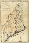
1795 Map of Maine
-
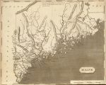
1804 Maine Map
-
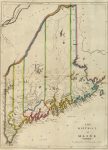
1814 Atlas Map of Maine
-
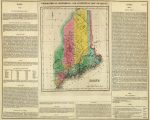
1822 Map of Maine
1822 Geographical, Historical, And Statistical Atlas Map Of Maine
-
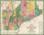
1827 Map of Maine, New Hampshire, and Vermont
-
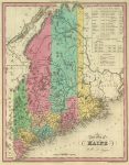
1836 Atlas Map of Maine
-
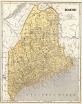
1845 Maine Map
-
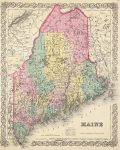
1856 Maine Map
-
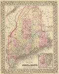
1880 Map of Maine
1880 County map of the state of Maine. (with) Portland Har. and vicinity
Maine Map Links
- Maine State Park Map (mapofus.org)
- Maine Lakes and Rivers Map (mapofus.org)
- Maine Map With Cities and Highways (mapofus.org)
- Old Historical Maps of Maine (alabamamaps.ua.edu)
- Maine Digital Map Library (usgwarchives.net)
- Maine Maps, Atlases & Gazetteers (ancestry.com)
- Maine Maps – The Perry-Castañeda Library Map Collection (lib.utexas.edu)
- U.S., Indexed County Land Ownership Maps, 1860-1918 (ancestry.com)
- A gazetteer of the state of Maine (ancestry.com)
- American Memory Map Collection: 1500-2004 (memory.loc.gov)
- Old Maps of Maine (old-maps.com)
- Maine Map Books (amazon.com)

