Maps of Ohio tend to be a vital element of genealogy and family tree research, particularly if you live far from where your ancestor resided. Given that Ohio political borders sometimes changed, historic maps are generally essential in assisting you find out the exact location of your ancestor’s home, exactly what land they owned, who their neighbors were, and much more.
Maps of Ohio usually have a tendency to be an excellent resource for getting started with your research, since they provide you with significantly useful information and facts right away. Ohio Maps are usually a major source of considerable detail on family history.
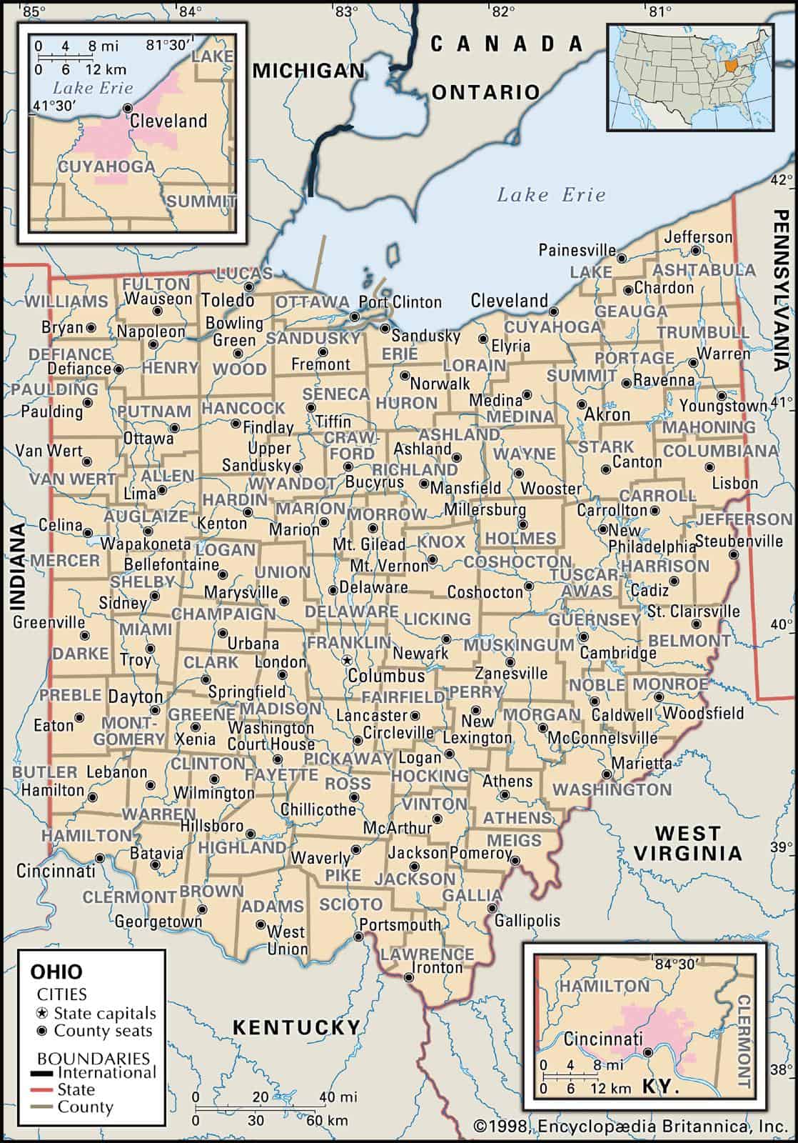
Ohio borders Pennsylvania, West Virginia, Kentucky, Indiana and Michigan. Ohio’s 10 largest cities are Columbus, Cleveland, Cincinnati, Toledo, Akron, Dayton, Parma, Youngstown, Canton and Lorain.
Learn more about Historical Facts of Ohio Counties.
Interactive Map of Ohio County Formation History
Understanding the Ohio Map
Ohio sits at a geographic crossroads that makes its map genuinely interesting to read. The state is bordered by the Ohio River to the south — forming the boundary with Kentucky and West Virginia — and by Lake Erie to the north. To the east, Pennsylvania; to the west, Indiana. Those borders aren’t arbitrary lines. The Ohio River was the original frontier, and Lake Erie shaped where the first northern cities grew. Everything in between is a story of rivers, glaciers, and survey lines.
If you’re looking at an Ohio map with counties, you’re looking at 88 of them — one of the higher county counts in the Midwest, a result of early Ohio law that kept counties small enough that no settler would have to travel more than half a day to reach a courthouse. That practical logic is baked into the grid you see on the map today.
Ohio’s Four Geographic Regions
The county map makes more sense once you understand that Ohio isn’t geographically uniform. There are roughly four zones, each with its own landscape, history, and character:
| Region | Representative Counties | Landscape | Notable Anchor |
|---|---|---|---|
| Lake Erie Shoreline | Cuyahoga, Erie, Ottawa, Ashtabula | Lakefront bluffs, river valleys, wine country | Cleveland, Cedar Point (Sandusky) |
| Northeast & Appalachian Foothills | Holmes, Tuscarawas, Athens, Hocking | Rolling hills, forested ridges, creek hollows | Amish Country, Hocking Hills |
| Central Plains | Franklin, Delaware, Fairfield, Licking | Gently rolling farmland, river corridors | Columbus |
| Northwest Flatlands | Lucas, Defiance, Fulton, Henry | Glaciated plains, the old Black Swamp | Toledo, Maumee River |
Major Ohio Cities by County
One of the most common things people want from an Ohio map is a quick way to connect cities to counties. Here’s a reference for Ohio’s ten largest cities:
| City | County |
|---|---|
| Columbus | Franklin County |
| Cleveland | Cuyahoga County |
| Cincinnati | Hamilton County |
| Toledo | Lucas County |
| Akron | Summit County |
| Dayton | Montgomery County |
| Parma | Cuyahoga County |
| Youngstown | Mahoning County |
| Canton | Stark County |
| Lorain | Lorain County |
A Note on the “Ohio Country”
Before Ohio became a state in 1803, the region was known as the Ohio Country — a term used by both French and British colonizers to describe the vast territory drained by the Ohio River. Control of this land was a central flashpoint of the French and Indian War, and later the American Revolution. When you look at the earliest county formations in the interactive map above, you’re watching that frontier territory get carved into something governable, county by county, decade by decade.
How to Read the Interactive County Formation Map
The animated map above shows how Ohio’s 88 counties were formed over time, starting from the original land purchases and territorial divisions. Watch how the large early counties — like Washington and Hamilton — get subdivided as population grew and settlers pushed further inland. Each new county boundary reflects a courthouse, a river crossing, or a community that needed its own local government. It’s a surprisingly readable piece of Ohio history.
List of Every Ohio County
Ohio’s 88 counties are listed below with their founding dates, county seats, and basic facts. Population figures reflect the 2020 U.S. Census. County boundaries shown in the interactive map above correspond to the entries below.
Adams County
Adams County was established on July 10, 1797, and its county seat is West Union. The county was named after John Adams, the second president of the United States. It has a population of 27,542 and covers an area of 583.91 square miles. Adams County sits in the hill country of southern Ohio, close to the Ohio River, and is home to Serpent Mound — one of the most significant prehistoric earthworks in North America.
Allen County
Allen County was established on March 1, 1820, and its county seat is Lima. The county was named after John Allen, a colonel in the War of 1812. It has a population of 101,670 and covers an area of 404.43 square miles. Lima sits near the center of Ohio’s northwestern flatlands, a region shaped by the retreat of glaciers that left behind some of the most productive farmland in the state.
Ashland County
Ashland County was established on February 24, 1846, and its county seat is Ashland. The county was formed from portions of Wayne, Richland, Huron, and Lorain counties. It was named after Ashland, the Kentucky estate of U.S. Senator Henry Clay. It has a population of 52,316 and covers an area of 424.37 square miles.
Ashtabula County
Ashtabula County was established on June 7, 1807, and its county seat is Jefferson. The county was formed from portions of Trumbull and Geauga counties. The name comes from the Ashtabula River — an Algonquian word meaning roughly “fish river.” It has a population of 97,337 and covers an area of 702.44 square miles, making it the largest county in Ohio by land area. The Lake Erie shoreline here is dotted with covered bridges and small harbor towns.
Athens County
Athens County was established on March 1, 1805, formed from Washington County, and named after Athens, Greece. The county has a population of 62,056 and covers an area of 506.76 square miles. It’s home to Ohio University and sits in the Appalachian foothills of southeastern Ohio — a region of wooded ridges and narrow valleys that feels quite different from the flat center of the state.
Auglaize County
Auglaize County was established on February 14, 1848, carved from Allen, Mercer, Darke, Hardin, Logan, Shelby, and Van Wert counties. It was named after the Auglaize River, whose name in the Shawnee language refers to fallen timbers — a reference to the debris-choked river channel early travelers encountered. The county has a population of 46,141 and covers an area of 401.25 square miles.
Belmont County
Belmont County was established on September 7, 1801, and formed from Jefferson and Washington counties. The name comes from the French for “beautiful mountain.” The county has a population of 65,849 and covers an area of 537.35 square miles. Belmont County is in eastern Ohio’s coal country, close to the West Virginia border.
Brown County
Brown County was established on March 1, 1818, formed from Adams and Clermont counties. It was named after General Jacob Brown (1775–1828), an officer of the War of 1812. The county has a population of 43,662 and covers an area of 491.76 square miles. Georgetown is the county seat.
Butler County
Butler County was established on May 1, 1803, formed from Hamilton County. It was named after General Richard Butler (1743–1791), killed at the Battle of the Wabash. The county has a population of 390,234 and covers an area of 467.27 square miles. Hamilton is the county seat, and Butler County is part of the greater Cincinnati metro area.
Carroll County
Carroll County was established on January 1, 1833, formed from Columbiana, Stark, Harrison, Jefferson, and Tuscarawas counties. It was named after Charles Carroll (1737–1832), the last surviving signer of the Declaration of Independence. The county has a population of 26,691 and covers an area of 394.67 square miles. Carrollton is the county seat.
Champaign County
Champaign County was established on March 1, 1805, formed from Greene and Franklin counties. The name comes from the French word for “a plain,” which accurately describes the open terrain here. The county has a population of 38,699 and covers an area of 428.56 square miles. Urbana is the county seat.
Clark County
Clark County was established on March 1, 1818, formed from Champaign, Madison, and Greene counties. It was named after General George Rogers Clark (1752–1818), who fought the Shawnee near what is now Springfield. The county has a population of 135,633 and covers an area of 399.86 square miles. Springfield is the county seat.
Clermont County
Clermont County was established on December 6, 1800, formed from Hamilton County. The name comes from the French for “clear mountain.” Its county seat is Batavia. As of the 2020 census, Clermont County had a population of 209,642 — the 14th most populous county in Ohio — and covers an area of 451.99 square miles. It sits east of Cincinnati along the Ohio River corridor.
Crawford County
Crawford County was established on April 1, 1820, named after Colonel William Crawford, a Revolutionary War officer. The county seat is Bucyrus, and its population is 41,754. Crawford County covers 402.11 square miles and lies in north-central Ohio’s agricultural belt.
Cuyahoga County
Cuyahoga County was founded on June 7, 1807, and is the second most populous county in Ohio. The county seat is Cleveland. The name “Cuyahoga” comes from a Native American word meaning “crooked river” — a fitting description of the winding waterway that runs through the county and into Lake Erie. Cuyahoga County has a population of 1,235,072 and covers an area of 1,245.90 square miles.
Darke County
Darke County was established on March 1, 1817, named after General William Darke, a Revolutionary War officer. The county seat is Greenville, and its population is 50,205. Darke County covers 600.63 square miles and is one of the more rural counties in western Ohio.
Defiance County
Defiance County was established on April 2, 1845, named after Fort Defiance — built at the confluence of the Auglaize and Maumee rivers during the War of 1812. The county seat is Defiance, and its population is 38,265. Defiance County covers 411.50 square miles in the far northwest corner of the state.
Delaware County
Delaware County was established on March 1, 1808, named after the Delaware tribe of Native Americans. The county seat is Delaware, and its population is 218,114 — one of the fastest-growing counties in Ohio, driven by Columbus’s northward expansion. Delaware County has an area of 456.09 square miles.
Erie County
Erie County was established on March 15, 1838, formed from Huron and Sandusky counties and named after the Erie Indians. The county seat is Sandusky. With a population of 74,852 and an area of 254.88 square miles, Erie County is home to Cedar Point — one of the most visited amusement parks in the world and a landmark that puts this small Lake Erie county on the map for travelers across the Midwest.
Fairfield County
Fairfield County was established on December 9, 1800, created from Ross and Washington counties, and named for its “fair fields.” The county seat is Lancaster. The county has a population of 161,064 and an area of 505.11 square miles. It sits southeast of Columbus and is part of the growing central Ohio region.
Fayette County
Fayette County was established on March 1, 1810, formed from Ross and Highland counties, and named after the Marquis de Lafayette. The county seat is Washington Court House — one of the more distinctive county seat names in Ohio. Fayette County covers an area of 406.58 square miles and has a population of 28,906.
Franklin County
Franklin County was established on April 30, 1803, and formed from Ross and Wayne counties and was named after Benjamin Franklin. The county seat is Columbus, which is also the state capital. Franklin County is the most populous county in Ohio, with a population of 1,321,414 and an area of 539.87 square miles. Columbus’s growth has made Franklin County one of the fastest-growing large counties in the entire Midwest.
Fulton County
Fulton County was established on April 1, 1850, formed from Lucas, Henry, and Williams counties, and named after Robert Fulton, inventor of the steamboat. The county seat is Wauseon. Fulton County has a population of 42,450 and covers an area of 406.78 square miles in the far northwest of the state, near the Michigan border.
Gallia County
Gallia County was established on April 30, 1803, created from Washington and Adams counties and named after Gaul — the ancient Roman name for France. The county seat is Gallipolis, a town with French colonial roots along the Ohio River. Gallia County has a population of 29,158 and covers an area of approximately 470 square miles in the southeastern corner of Ohio.
Geauga County
Geauga County was established on December 31, 1805, formed from Trumbull County. The name comes from a Seneca word for “raccoon.” The county seat is Chardon, and the county has a population of approximately 93,000. Geauga County is known for its maple syrup production and sits in the snowbelt east of Cleveland.
Greene County
Greene County was established on March 24, 1803, named after General Nathanael Greene of the Revolutionary War. The county seat is Xenia. Greene County has a population of approximately 168,000 and covers about 415 square miles. It’s home to Wright-Patterson Air Force Base, one of the largest military installations in the country.
Guernsey County
Guernsey County was established on January 31, 1810, formed from Muskingum and Belmont counties. It was named after the Isle of Guernsey in the English Channel, reflecting the heritage of early settlers. The county seat is Cambridge, and the county has a population of approximately 38,000 and covers about 522 square miles in eastern Ohio.
Hamilton County
Hamilton County was established on January 2, 1790 — one of the original counties of the Northwest Territory — and named after Alexander Hamilton. The county seat is Cincinnati, and Hamilton County is the third most populous county in Ohio with a population of approximately 830,000. It sits at the southwestern corner of the state along the Ohio River, directly across from Kentucky.
Hancock County
Hancock County was established on February 12, 1820, named after John Hancock, president of the Continental Congress. The county seat is Findlay. Hancock County has a population of approximately 75,000 and covers about 531 square miles in northwest Ohio. Findlay is known as “Flag City USA” for its tradition of flag displays.
Hardin County
Hardin County was established on February 12, 1820, named after Colonel John Hardin, a Revolutionary War officer killed in 1792. The county seat is Kenton. Hardin County has a population of approximately 31,000 and covers about 470 square miles in north-central Ohio.
Harrison County
Harrison County was established on February 1, 1813, named after William Henry Harrison, later the ninth president of the United States. The county seat is Cadiz. Harrison County has a population of approximately 15,000 — one of Ohio’s least populous counties — and covers about 404 square miles in eastern Ohio’s hill country.
Henry County
Henry County was established on February 12, 1820, named after Patrick Henry. The county seat is Napoleon. Henry County has a population of approximately 27,000 and covers about 417 square miles in the Maumee River valley of northwest Ohio.
Highland County
Highland County was established on May 1, 1805, formed from Ross, Adams, and Clermont counties. The county seat is Hillsboro. Highland County has a population of approximately 43,000 and covers about 554 square miles in south-central Ohio.
Hocking County
Hocking County was established on January 3, 1818, named after the Hocking River. The county seat is Logan. Hocking County has a population of approximately 28,000 and covers about 423 square miles. It’s best known for Hocking Hills State Park — one of Ohio’s most visited natural areas, featuring sandstone gorges, waterfalls, and cave recesses that draw hikers from across the region.
Holmes County
Holmes County was established on January 20, 1824, named after Major Andrew Holmes, killed in the War of 1812. The county seat is Millersburg. Holmes County has a population of approximately 44,000 and covers about 423 square miles. It has the largest Amish population of any county in the world, and the backroads here — lined with farms, buggy traffic, and roadside stands — are unlike anywhere else on an Ohio map.
Huron County
Huron County was established on February 7, 1809, named after the Huron (Wyandot) people. The county seat is Norwalk. Huron County has a population of approximately 58,000 and covers about 494 square miles in north-central Ohio between the Lake Erie shore and the interior.
Jackson County
Jackson County was established on March 1, 1816, named after Andrew Jackson. The county seat is Jackson. Jackson County has a population of approximately 32,000 and covers about 420 square miles in southern Ohio’s hill country.
Jefferson County
Jefferson County was established on July 29, 1797 — one of Ohio’s original counties — named after Thomas Jefferson. The county seat is Steubenville. Jefferson County has a population of approximately 65,000 and covers about 409 square miles along the Ohio River in eastern Ohio, bordering West Virginia.
Knox County
Knox County was established on January 30, 1808, named after General Henry Knox, the first U.S. Secretary of War. The county seat is Mount Vernon. Knox County has a population of approximately 62,000 and covers about 527 square miles in central Ohio.
Lake County
Lake County was established on March 6, 1840, named for its position on Lake Erie. The county seat is Painesville. Lake County has a population of approximately 232,000 and covers about 228 square miles — one of Ohio’s smallest counties by area but among its more densely populated. It sits between Cleveland and Ashtabula along the shore of Lake Erie.
Lawrence County
Lawrence County was established on December 21, 1815, named after Captain James Lawrence of the War of 1812, famous for the phrase “Don’t give up the ship.” The county seat is Ironton. Lawrence County has a population of approximately 59,000 and covers about 455 square miles at the southernmost tip of Ohio along the Ohio River.
Licking County
Licking County was established on January 30, 1808, named after the Licking River. The county seat is Newark. Licking County, located east of Columbus, has a population of approximately 176,000 and covers about 686 square miles. It’s home to the Newark Earthworks, a complex of ancient Hopewell earthworks that is one of the world’s largest geometric earthwork systems.
Logan County
Logan County was established on March 1, 1817, named after Benjamin Logan, a Kentucky pioneer. The county seat is Bellefontaine, which sits on Campbell Hill — the highest point in Ohio at 1,549 feet. Logan County has a population of approximately 45,000 and covers about 458 square miles.
Lorain County
Lorain County was established on December 26, 1822, named after Lorraine, France. The county seat is Elyria. Lorain County has a population of approximately 309,000 and covers about 493 square miles along Lake Erie west of Cleveland. The city of Lorain sits on the lake and has a long industrial and maritime history.
Lucas County
Lucas County was established on June 20, 1835, named after Robert Lucas, governor of Ohio. The county seat is Toledo. Lucas County has a population of approximately 432,000 and covers about 341 square miles at the western end of Lake Erie. Toledo’s position at the mouth of the Maumee River made it a critical Great Lakes port.
Madison County
Madison County was established on March 1, 1810, named after James Madison. The county seat is London. Madison County has a population of approximately 44,000 and covers about 466 square miles in west-central Ohio, part of the flat agricultural corridor between Columbus and Dayton.
Mahoning County
Mahoning County was established on March 1, 1846, named after the Mahoning River, a Lenape word meaning “at the licks.” The county seat is Youngstown. Mahoning County has a population of approximately 229,000 and covers about 415 square miles in northeast Ohio, close to the Pennsylvania border.
Marion County
Marion County was established on February 12, 1820, named after General Francis Marion, the “Swamp Fox” of the Revolutionary War. The county seat is Marion. Marion County has a population of approximately 65,000 and covers about 404 square miles in north-central Ohio. Marion was the hometown of President Warren G. Harding.
Medina County
Medina County was established on February 12, 1812, named after Medina, a city in Saudi Arabia. The county seat is Medina. Medina County has a population of approximately 179,000 and covers about 422 square miles south of Cleveland. The town square in Medina is one of the most photographed in Ohio.
Meigs County
Meigs County was established on January 21, 1819, and was named after Return Jonathan Meigs Jr., the governor of Ohio. The county seat is Pomeroy, which sits right on the Ohio River. Meigs County has a population of approximately 22,000 and covers about 432 square miles in southeastern Ohio.
Mercer County
Mercer County was established on February 12, 1820, named after General Hugh Mercer of the Revolutionary War. The county seat is Celina, which sits on Grand Lake St. Marys — one of the largest inland lakes in Ohio. Mercer County has a population of approximately 41,000 and covers about 463 square miles in western Ohio.
Miami County
Miami County was established on January 16, 1807, named after the Miami people. The county seat is Troy. Miami County has a population of approximately 107,000 and covers about 407 square miles north of Dayton along the Great Miami River.
Monroe County
Monroe County was established on January 29, 1813, named after James Monroe. The county seat is Woodsfield. Monroe County has a population of approximately 13,000 — Ohio’s least populous county — and covers about 456 square miles in the hill country of southeastern Ohio near the West Virginia border.
Montgomery County
Montgomery County was established on May 1, 1803, named after General Richard Montgomery of the Revolutionary War. The county seat is Dayton. Montgomery County has a population of approximately 535,000 and covers about 461 square miles in southwestern Ohio. Dayton is known as the birthplace of aviation — the Wright Brothers’ workshop was here.
Morgan County
Morgan County was established on December 29, 1817, named after General Daniel Morgan of the Revolutionary War. The county seat is McConnelsville. Morgan County has a population of approximately 14,000 and covers about 418 square miles in the Muskingum River valley of southeastern Ohio.
Morrow County
Morrow County was established on March 1, 1848, and was named after Jeremiah Morrow, the governor of Ohio. The county seat is Mount Gilead. Morrow County has a population of approximately 35,000 and covers about 406 square miles in north-central Ohio.
Muskingum County
Muskingum County was established on January 7, 1804, named after the Muskingum River — a Delaware word meaning “moose eye” or “elk eye.” The county seat is Zanesville, which served briefly as the state capital of Ohio. Muskingum County has a population of approximately 86,000 and covers about 665 square miles in east-central Ohio.
Noble County
Noble County was established on March 11, 1851, named after James Noble, an early settler. The county seat is Caldwell. Noble County has a population of approximately 14,000 and covers about 399 square miles in southeastern Ohio’s hill country.
Ottawa County
Ottawa County was established on March 6, 1840, named after the Ottawa people. The county seat is Port Clinton. Ottawa County has a population of approximately 40,000 and covers about 255 square miles on the Lake Erie shore. It includes the Lake Erie Islands — South Bass Island (Put-in-Bay), Kelleys Island, and Middle Bass Island — popular summer destinations accessible by ferry.
Paulding County
Paulding County was established on February 12, 1820, named after John Paulding, one of the captors of British spy John André during the Revolutionary War. The county seat is Paulding. Paulding County has a population of approximately 18,000 and covers about 416 square miles in the flat northwest corner of Ohio.
Perry County
Perry County was established on March 1, 1818, named after Commodore Oliver Hazard Perry, hero of the Battle of Lake Erie. The county seat is New Lexington. Perry County has a population of approximately 36,000 and covers about 410 square miles in east-central Ohio.
Pickaway County
Pickaway County was established on March 1, 1810, named after the Piqua (Pickaway) band of the Shawnee. The county seat is Circleville, home to the annual Circleville Pumpkin Show — one of Ohio’s oldest and largest festivals. Pickaway County has a population of approximately 58,000 and covers about 503 square miles south of Columbus.
Pike County
Pike County was established on January 4, 1815, named after General Zebulon Pike, explorer and soldier. The county seat is Waverly. Pike County has a population of approximately 27,000 and covers about 443 square miles in southern Ohio.
Portage County
Portage County was established on June 7, 1807, named after the portage path between the Cuyahoga and Tuscarawas rivers used by Native Americans and early traders. The county seat is Ravenna. Portage County has a population of approximately 162,000 and covers about 492 square miles in northeast Ohio. Kent State University is located here.
Preble County
Preble County was established on March 1, 1808, named after Commodore Edward Preble of the U.S. Navy. The county seat is Eaton. Preble County has a population of approximately 41,000 and covers about 426 square miles in western Ohio near the Indiana border.
Putnam County
Putnam County was established on February 12, 1820, named after General Israel Putnam of the Revolutionary War. The county seat is Ottawa. Putnam County has a population of approximately 34,000 and covers about 484 square miles in northwest Ohio.
Richland County
Richland County was established on January 30, 1808, named for its fertile land. The county seat is Mansfield. Richland County has a population of approximately 121,000 and covers about 496 square miles in north-central Ohio. Mohican State Park and the surrounding forest make Richland County a popular outdoor destination.
Ross County
Ross County was established on August 20, 1798 — one of Ohio’s earliest counties — named after James Ross, a U.S. Senator from Pennsylvania. The county seat is Chillicothe, which served as Ohio’s first state capital. Ross County has a population of approximately 77,000 and covers about 692 square miles in south-central Ohio. The Hopewell Culture National Historical Park is located here.
Sandusky County
Sandusky County was established on February 12, 1820, named after the Sandusky River — a Wyandot word. The county seat is Fremont. Sandusky County has a population of approximately 58,000 and covers about 409 square miles in north-central Ohio.
Scioto County
Scioto County was established on March 24, 1803, named after the Scioto River. The county seat is Portsmouth, which sits at the confluence of the Scioto and Ohio rivers. Scioto County has a population of approximately 74,000 and covers about 612 square miles in southern Ohio.
Seneca County
Seneca County was established on February 12, 1820, named after the Seneca people. The county seat is Tiffin. Seneca County has a population of approximately 55,000 and covers about 551 square miles in north-central Ohio.
Shelby County
Shelby County was established on January 7, 1819, named after Isaac Shelby, first governor of Kentucky. The county seat is Sidney. Shelby County has a population of approximately 48,000 and covers about 409 square miles in west-central Ohio.
Stark County
Stark County was established on February 13, 1809, named after General John Stark of the Revolutionary War. The county seat is Canton. Stark County has a population of approximately 374,000 and covers about 576 square miles in northeast Ohio. Canton is home to the Pro Football Hall of Fame.
Summit County
Summit County was established on March 3, 1840, named for its position at the summit of the Ohio and Erie Canal. The county seat is Akron. Summit County has a population of approximately 541,000 and covers about 413 square miles in northeast Ohio. Akron grew as a rubber manufacturing center and remains one of Ohio’s major cities.
Trumbull County
Trumbull County was established on July 10, 1800, named after Jonathan Trumbull, governor of Connecticut. The county seat is Warren. Trumbull County has a population of approximately 197,000 and covers about 618 square miles in northeast Ohio near the Pennsylvania border.
Tuscarawas County
Tuscarawas County was established on February 13, 1808, named after the Tuscarawas River — a Delaware word. The county seat is New Philadelphia. Tuscarawas County has a population of approximately 92,000 and covers about 568 square miles in east-central Ohio. The county borders Holmes County and shares the cultural landscape of Ohio’s Amish region.
Union County
Union County was established on January 10, 1820, named for the union of parts of several counties from which it was formed. The county seat is Marysville. Union County has a population of approximately 58,000 and covers about 437 square miles northwest of Columbus. It has been one of Ohio’s fastest-growing counties as Columbus’s suburbs expand.
Van Wert County
Van Wert County was established on February 12, 1820, named after Isaac Van Wart, one of the captors of British spy John André. The county seat is Van Wert. Van Wert County has a population of approximately 28,000 and covers about 410 square miles in the flat northwest corner of Ohio.
Vinton County
Vinton County was established on March 23, 1850, named after Samuel Finley Vinton, an Ohio congressman. The county seat is McArthur. Vinton County has a population of approximately 13,000 and covers about 414 square miles. It is Ohio’s least densely populated county and sits in the forested hill country of southeastern Ohio.
Warren County
Warren County was established on May 1, 1803, named after General Joseph Warren, killed at the Battle of Bunker Hill. The county seat is Lebanon. Warren County has a population of approximately 240,000 and covers about 406 square miles north of Cincinnati. It has grown rapidly as part of the greater Cincinnati metro area.
Washington County
Washington County was established on July 27, 1788 — the first county established in the Northwest Territory — named after George Washington. The county seat is Marietta, also the first permanent American settlement in the Northwest Territory. Washington County has a population of approximately 60,000 and covers about 640 square miles in southeastern Ohio along the Ohio River.
Wayne County
Wayne County was established on August 15, 1796, named after General Anthony Wayne, who defeated a confederation of Native American tribes at the Battle of Fallen Timbers. The county seat is Wooster. Wayne County has a population of approximately 116,000 and covers about 555 square miles in northeast Ohio. It borders Holmes County and is part of the broader Amish Country region.
Williams County
Williams County was established on February 12, 1820, named after David Williams, one of the captors of British spy John André. The county seat is Bryan. Williams County has a population of approximately 36,000 and covers about 422 square miles in the far northwest corner of Ohio, bordering both Indiana and Michigan.
Wood County
Wood County was established on February 12, 1820, named after Eleazer Wood, an army officer killed in the War of 1812. The county seat is Bowling Green. Wood County has a population of approximately 130,000 and covers about 619 square miles in northwest Ohio. Bowling Green State University is located here.
Wyandot County
Wyandot County was established on February 3, 1845, named after the Wyandot people, one of the last Native American groups to be removed from Ohio. The county seat is Upper Sandusky. Wyandot County has a population of approximately 21,000 and covers about 407 square miles in north-central Ohio.
What the Ohio County Map Tells You
Spend a few minutes with an Ohio county map, and some patterns start to emerge. The largest counties by area tend to cluster in the south and east — the hill country where early settlement was slower and the demand for local courthouses less urgent. The smallest counties are in the northeast, where the Western Reserve was settled quickly by New Englanders who brought their town-based political culture with them.
The county names themselves are a compressed history of the early republic: presidents, Revolutionary War generals, Native American nations, French geographic descriptions, and the occasional nod to a river or a landscape feature. Holmes County honors a War of 1812 officer. Gallia County honors France. Cuyahoga County honors a river. Each name is a small clue about who was here, who was being honored, and what mattered to the people drawing the lines.
If you’re using this page for genealogy research, the interactive county formation map above is especially useful. Ohio’s county boundaries shifted significantly between 1788 and 1850 — a record that existed in one county in 1810 might be filed under a completely different county name by 1830. Tracking those boundary changes is often the key to finding a missing ancestor in Ohio’s historical records.