Maps of Mississippi are an important piece of ancestral and family history research, especially in the event that you live far from where your ancestor was living.
Given that Mississippi’s political borders have frequently changed over the years, historic maps can be critical in helping you find out the precise location of your ancestor’s hometown, exactly what land they owned, who their neighbors were, and much more besides.
Maps of Mississippi are an exceptional source for starting out with your own research because they provide you with useful information and facts immediately, and then present them in a clear and easily understandable manner.
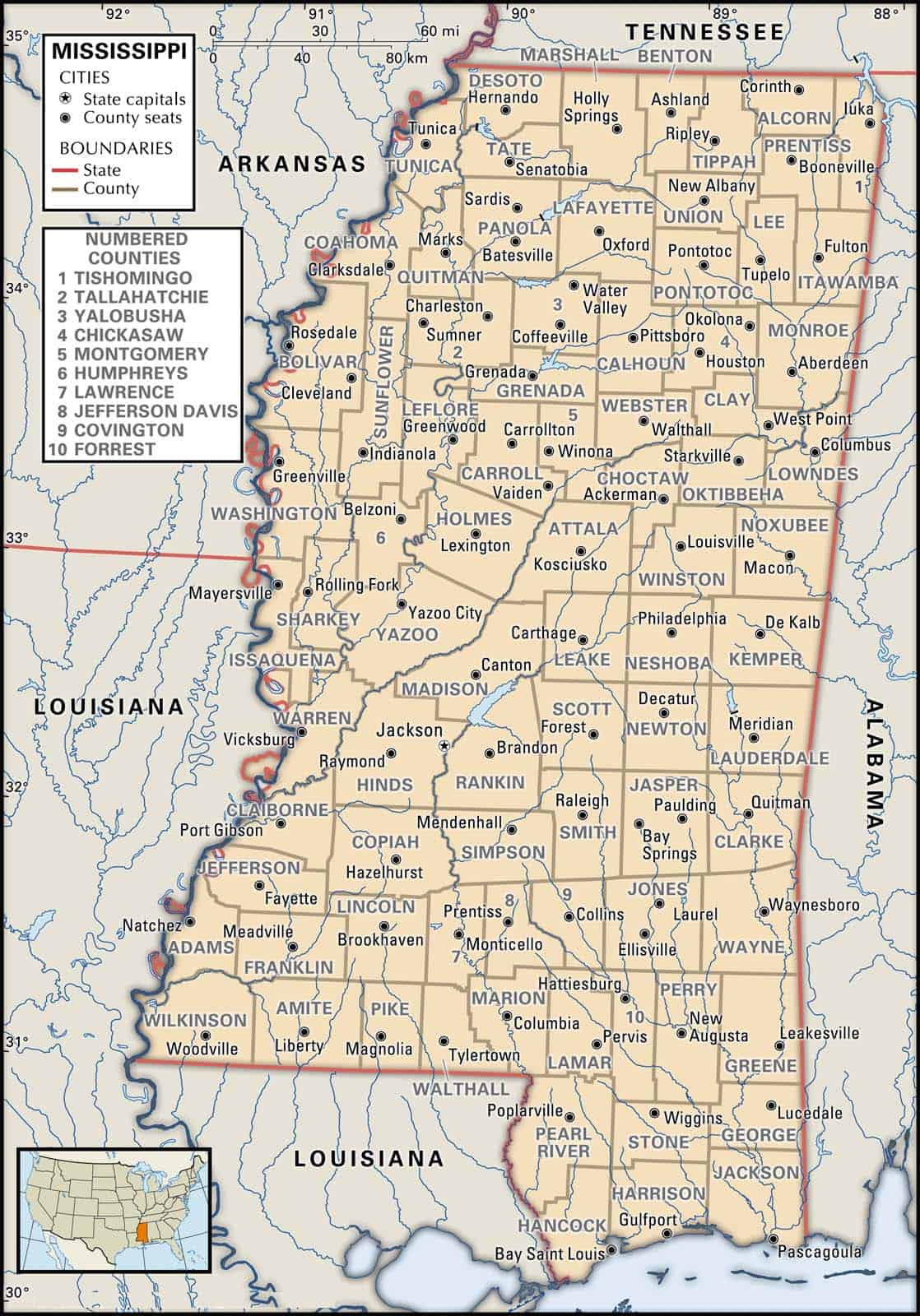
The states that border Mississippi are Alabama, Arkansas, Louisiana, and Tennessee. Mississippi’s 10 largest cities are Jackson, Gulfport, Hattiesburg, Southaven, Biloxi, Meridian, Tupelo, Greenville, Olive Branch, and Horn Lake.
Learn more historical facts about Mississippi counties here.
County highway maps, produced by the Mississippi Department of Transportation, Map Sales Office, P.O. Box 1850, Jackson, MS 39215-1850, are available for a nominal fee. These maps are useful when trying to locate cemeteries in the state.
Interactive Map of Mississippi County Formation History
AniMap Plus 3.0, with the permission of the Goldbug Company
Mississippi’s 82 Counties: What the Map Actually Shows You
Mississippi goes by MS for short, and if you’ve landed here looking for a county map of the state, you’re in the right place. The interactive map above lets you watch how those 82 counties took shape over time — which is a surprisingly useful thing to see, especially if you’re doing genealogy research or just trying to figure out why the Delta looks so different from the Gulf Coast on paper.
The state borders Alabama to the east, Arkansas and Louisiana to the west, Tennessee to the north, and Louisiana again (plus the Gulf of Mexico) to the south. That geography matters more than it might seem: the Mississippi River along the western edge shaped entire counties, flooded them, moved their boundaries, and made some of the richest farmland in the country. The hills in the northeast, the longleaf pine forests in the south, and the coastal strip along Harrison and Hancock counties are all distinct worlds that show up clearly once you start clicking through the county formation history.
Mississippi County Quick Facts
- Total counties: 82
- Oldest counties: Adams and Jefferson (both established 1799)
- Newest county: Humphreys (established 1918)
- Most populous county: Hinds (~230,000) — home to Jackson, the state capital
- Least populous county: Issaquena (~1,200) — one of the least populated counties in the entire United States
- Largest county by area: Yazoo County
Five Regions Worth Knowing Before You Zoom In
Mississippi doesn’t divide itself into official regions, but locals and road-trippers tend to think in these five geographic zones. Knowing which region a county sits in makes the map a lot easier to read.
| Region | General Location | Sample Counties | Cities You Might Recognize |
|---|---|---|---|
| The Delta | Northwest flatlands along the Mississippi River | Coahoma, Bolivar, Sunflower, Leflore, Washington, Humphreys, Issaquena | Clarksdale, Greenville, Greenwood, Belzoni |
| The Hills | Northeast corner, rolling terrain | Lee, Alcorn, Tishomingo, Lafayette, Pontotoc, Itawamba | Tupelo, Corinth, Oxford |
| Capital / Central | Middle of the state | Hinds, Rankin, Madison, Copiah, Simpson, Attala | Jackson, Ridgeland, Brandon, Kosciusko |
| Piney Woods | South-central, longleaf pine country | Jones, Forrest, Lamar, Perry, Wayne, Covington | Hattiesburg, Laurel, Petal |
| Gulf Coast | Southernmost strip along the Gulf of Mexico | Harrison, Hancock, Jackson | Gulfport, Biloxi, Bay St. Louis, Pascagoula, Ocean Springs |
How to Use the County Formation Map for Genealogy
If you’re tracking down an ancestor in Mississippi, the county formation history is genuinely important — not just interesting. County boundaries shifted constantly through the 1800s, which means a family that never moved could appear in two or three different counties across successive census records. An ancestor recorded in “Yazoo County” in 1840 might show up in a newly carved county by 1850, even if they stayed on the same land.
The interactive map above shows exactly how those boundaries evolved. Pair it with the historical facts about Mississippi counties at RAOGK and the David Rumsey Historical Map Collection for period maps that show what the landscape actually looked like when your ancestor was there.
For locating cemeteries specifically, the county highway maps produced by the Mississippi Department of Transportation are surprisingly useful — each county has a downloadable PDF linked in the county list below.
List of Every Mississippi County
All 82 counties are listed alphabetically below. Each entry links to the MDOT county highway map PDF — handy for navigating back roads, finding rural cemeteries, or just getting a detailed look at a specific county’s road network.
Adams County
Established in 1799, Adams County is one of Mississippi’s two original counties and sits at the southwestern corner of the state along the Mississippi River. The county seat is Natchez, which has one of the most intact collections of antebellum architecture in the South — the historic district along the bluffs above the river is worth a slow walk. Adams County is also the southern terminus of the Natchez Trace Parkway, making it a natural starting point for a drive north through the state. Population: approximately 30,000. Adams County highway map (PDF)
Alcorn County
Established in 1870, Alcorn County sits in the northeast corner of the state near the Tennessee border. The county seat is Corinth, a town with significant Civil War history — the Battle of Corinth in 1862 was a major engagement in the western theater. Tishomingo State Park is nearby and worth a stop for the rock formations, which are unusual for Mississippi’s generally flat terrain. Population: approximately 37,000. Alcorn County highway map (PDF)
Amite County
Established in 1809, Amite County occupies the southwestern corner of the state, bordering Louisiana. The county seat is Liberty. It’s quiet, heavily forested country — the kind of place where the road signs start to thin out and the pines take over. Population: approximately 12,000. Amite County highway map (PDF)
Attala County
Established in 1833, Attala County sits near the geographic center of the state. The county seat is Kosciusko, named after the Polish military engineer Tadeusz Kościuszko. The area has several lakes and is a reasonable base for fishing in central Mississippi. Population: approximately 18,000. Attala County highway map (PDF)
Benton County
Established in 1870, Benton County is one of Mississippi’s smaller and more rural counties, tucked into the far north along the Tennessee border. The county seat is Ashland. Population: approximately 8,000. Benton County highway map (PDF)
Bolivar County
Established in 1836, Bolivar County is deep Delta territory — flat, agricultural, and historically one of the most cotton-intensive counties in the state. The county seat is Cleveland, home to Delta State University. The blues music trail runs through this part of the Delta. Population: approximately 30,000. Bolivar County highway map (PDF)
Calhoun County
Established in 1852, Calhoun County sits in the north-central part of the state. The county seat is Pittsboro. It’s rolling hill country, less traveled than the counties along the Natchez Trace but worth a look on the map for its geography. Population: approximately 14,000. Calhoun County highway map (PDF)
Carroll County
Established in 1833, Carroll County straddles the line between the Delta and the Hills. The county seat is Carrollton, which has a well-preserved antebellum courthouse. The county saw action during the Civil War, and the landscape still carries that layered history. Population: approximately 10,000. Carroll County highway map (PDF)
Chickasaw County
Established in 1836, Chickasaw County takes its name from the Chickasaw Nation, whose territory covered much of northern Mississippi before removal in the 1830s. The county seat is Houston. The Natchez Trace Parkway passes through the western edge of the county. Population: approximately 17,000. Chickasaw County highway map (PDF)
Choctaw County
Established in 1833 and named for the Choctaw Nation, Choctaw County sits in the central part of the state. The county seat is Ackerman. It’s hunting and fishing country, with the Tombigbee National Forest covering a significant portion of the county. Population: approximately 8,000. Choctaw County highway map (PDF)
Claiborne County
Established in 1802, Claiborne County sits along the Mississippi River in the southwest. The county seat is Port Gibson, a town Ulysses S. Grant reportedly called “too beautiful to burn” during the Civil War — though historians debate the quote. The Windsor Ruins, the remains of a massive antebellum plantation house, are in the county and genuinely striking. Population: approximately 9,000. Claiborne County highway map (PDF)
Clarke County
Established in 1812, Clarke County is in the east-central part of the state near the Alabama border. The county seat is Quitman. The Chickasawhay River runs through the county, and it’s known for hunting and fishing. Population: approximately 16,000. Clarke County highway map (PDF)
Clay County
Established in 1871, Clay County is in the northeast part of the state. The county seat is West Point. The Tennessee-Tombigbee Waterway passes through the county, which changed the economic geography of the region significantly when it opened in 1985. Population: approximately 20,000. Clay County highway map (PDF)
Coahoma County
Established in 1836, Coahoma County is the heart of blues country. The county seat is Clarksdale, which has a legitimate claim to being the birthplace of the Delta blues — Muddy Waters, Son House, and Robert Johnson all have deep connections here. The Delta Blues Museum in Clarksdale is one of the better small museums in the state. Population: approximately 24,000. Coahoma County highway map (PDF)
Copiah County
Established in 1823, Copiah County is in the southwest-central part of the state. The county seat is Hazlehurst. The county has a mix of historic homes and agricultural land, and it sits along the I-55 corridor between Jackson and the Louisiana border. Population: approximately 29,000. Copiah County highway map (PDF)
Covington County
Established in 1819, Covington County is in the Piney Woods region of south-central Mississippi. The county seat is Collins. Timber and forestry have been the economic backbone here for generations. Population: approximately 19,000. Covington County highway map (PDF)
DeSoto County
Established in 1836, DeSoto County is Mississippi’s fastest-growing county and sits directly south of Memphis, Tennessee. The county seat is Hernando, but the county’s population is largely suburban — communities like Southaven, Horn Lake, and Olive Branch function as Memphis suburbs. With a population of approximately 173,000, it’s the third most populous county in the state. DeSoto County highway map (PDF)
Forrest County
Established in 1906, Forrest County is the anchor of the Piney Woods region. The county seat is Hattiesburg, home to the University of Southern Mississippi and Camp Shelby. Hattiesburg has a lively arts scene for a mid-sized Southern city, and the area around it — including the DeSoto National Forest — offers good hiking and camping. Population: approximately 76,000. Forrest County highway map (PDF)
Franklin County
Established in 1809, Franklin County is in the southwest corner of the state. The county seat is Meadville. The Homochitto National Forest covers a large portion of the county — it’s longleaf pine restoration country and one of the less-visited national forests in the region. Population: approximately 8,000. Franklin County highway map (PDF)
George County
Established in 1910, George County is in the south near the Alabama border. The county seat is Lucedale. It’s rural and quiet, with the Pascagoula River watershed running through it — one of the last free-flowing river systems in the lower 48. Population: approximately 25,000. George County highway map (PDF)
Greene County
Established in 1811, Greene County sits in the far south near the Alabama line. The county seat is Leakesville. The Leaf River runs through the county, and it’s popular with anglers and hunters. Population: approximately 13,000. Greene County highway map (PDF)
Grenada County
Established in 1870, Grenada County is in the north-central part of the state. The county seat is Grenada, which sits on Grenada Lake — a Corps of Engineers reservoir that’s one of the better fishing lakes in the state. Population: approximately 21,000. Grenada County highway map (PDF)
Hancock County
Established in 1812, Hancock County anchors the western end of Mississippi’s Gulf Coast. The county seat is Bay St. Louis, a small city with a strong arts community and a walkable downtown that rebuilt itself after Hurricane Katrina. The beaches here are less developed than Biloxi and worth the detour. Population: approximately 47,000. Hancock County highway map (PDF)
Harrison County
Established in 1841, Harrison County is Mississippi’s second most populous county (approximately 210,000) and the center of the Gulf Coast tourism economy. The county seat is Gulfport, and Biloxi — home to the casino strip, Beauvoir (Jefferson Davis’s last home), and the Biloxi Lighthouse — is also in the county. US-90 along the coast is one of the more scenic drives in the state. Harrison County highway map (PDF)
Hinds County
Established in 1821, Hinds County is Mississippi’s most populous county (approximately 230,000) and home to Jackson, the state capital. Jackson has the Mississippi Museum of Natural Science, the Mississippi Civil Rights Museum, and the Two Mississippi Museums complex — more worth-your-time stops than the city usually gets credit for. Raymond, the other county seat (Hinds has two), is a small town with a notable Civil War battlefield nearby. Hinds County highway map (PDF)
Holmes County
Established in 1833, Holmes County sits in the Delta transition zone — part flatland, part rolling hills. The county seat is Lexington. It’s one of the more rural counties in the state, with a strong agricultural history. Population: approximately 17,000. Holmes County highway map (PDF)
Humphreys County
Established in 1918, Humphreys County is one of Mississippi’s newest counties and sits squarely in the Delta. The county seat is Belzoni, which calls itself the Catfish Capital of the World — farmed catfish is a real industry here. Population: approximately 8,000. Humphreys County highway map (PDF)
Issaquena County
Established in 1844, Issaquena County is the least populous county in Mississippi and one of the least populous counties in the entire United States, with a population of roughly 1,200. The county seat is Mayersville. It’s deep Delta country — mostly bottomland hardwood forest and agricultural fields along the Mississippi River. If you’re looking for it on the map, it’s the narrow county wedged between Sharkey and the river. Issaquena County highway map (PDF)
Itawamba County
Established in 1836, Itawamba County is in the northeast corner of the state near the Alabama border. The county seat is Fulton. The Tennessee-Tombigbee Waterway forms part of the county’s eastern boundary. Population: approximately 23,000. Itawamba County highway map (PDF)
Jackson County
Established in 1812, Jackson County is the easternmost Gulf Coast county, bordering Alabama. The county seat is Pascagoula, which has a long history of shipbuilding — Ingalls Shipbuilding has been a major employer here for decades. Ocean Springs, also in the county, is one of the more charming small towns on the Gulf Coast, with a strong arts scene and good seafood. Population: approximately 155,000. Jackson County highway map (PDF)
Jasper County
Established in 1833, Jasper County is in the east-central part of the state. The county seat is Bay Springs, which sits on the Ross Barnett Reservoir’s eastern tributary system. Outdoor recreation — fishing, hunting, hiking — is the main draw. Population: approximately 16,000. Jasper County highway map (PDF)
Jefferson County
Established in 1799 alongside Adams County, Jefferson County is one of Mississippi’s two original counties. The county seat is Fayette. It’s a small, rural county along the Mississippi River corridor with a history that goes back to the earliest days of American settlement in the region. Population: approximately 7,000. Jefferson County highway map (PDF)
Jefferson Davis County
Established in 1906 and named for the Confederate president, Jefferson Davis County is in the south-central part of the state. The county seat is Prentiss. It’s quiet, rural Piney Woods country. Population: approximately 11,000. Jefferson Davis County highway map (PDF)
Jones County
Established in 1826, Jones County has an unusual Civil War history — it was so opposed to secession that it was sometimes called the “Free State of Jones,” a story that has been the subject of books and a film. The county seat is Laurel, which has a beautifully restored downtown and is home to the Mississippi School of the Arts. Population: approximately 68,000. Jones County highway map (PDF)
Kemper County
Established in 1833, Kemper County is in the east-central part of the state near the Alabama border. The county seat is De Kalb. It’s rural and lightly populated, with the Chunky River running through it. Population: approximately 9,000. Kemper County highway map (PDF)
Lafayette County
Established in 1836, Lafayette County is home to Oxford and the University of Mississippi (Ole Miss). Oxford has a well-known literary identity — William Faulkner lived here, and the Square is one of the more lively small-city downtowns in the state. If you’re driving through north Mississippi, Oxford is worth a stop. Population: approximately 55,000. Lafayette County highway map (PDF)
Lamar County
Established in 1904, Lamar County is directly west of Forrest County and part of the greater Hattiesburg metro area. The county seat is Purvis. It’s one of the fastest-growing counties in the state, driven by suburban expansion from Hattiesburg. Population: approximately 63,000. Lamar County highway map (PDF)
Lauderdale County
Established in 1833, Lauderdale County is in the east-central part of the state near the Alabama border. The county seat is Meridian, Mississippi’s fifth-largest city and a historic railroad hub. The Jimmie Rodgers Museum is here — Rodgers, the “Father of Country Music,” was born in Meridian. Population: approximately 74,000. Lauderdale County highway map (PDF)
Lawrence County
Established in 1814, Lawrence County is in the south-central part of the state. The county seat is Monticello. The Pearl River runs along the county’s eastern edge. Population: approximately 12,000. Lawrence County highway map (PDF)
Leake County
Established in 1833, Leake County is in the central part of the state. The county seat is Carthage. The Choctaw community at Pearl River — one of the largest Native American communities in the Southeast — is in neighboring Neshoba County but has economic ties throughout this region. Population: approximately 22,000. Leake County highway map (PDF)
Lee County
Established in 1866, Lee County is in the northeast and is home to Tupelo, Mississippi’s third-largest city. Tupelo is Elvis Presley’s birthplace — the Elvis Presley Birthplace and Museum is a genuine draw. The county also sits along the Natchez Trace Parkway, and the Tupelo National Battlefield marks a Civil War engagement fought here in 1864. Population: approximately 85,000. Lee County highway map (PDF)
Leflore County
Established in 1871, Leflore County is in the heart of the Delta. The county seat is Greenwood, which sits at the confluence of the Tallahatchie and Yalobusha rivers where they form the Yazoo River. Greenwood has a strong blues heritage and a surprising number of good restaurants for a Delta town. Population: approximately 28,000. Leflore County highway map (PDF)
Lincoln County
Established in 1870, Lincoln County is in the southwest-central part of the state. The county seat is Brookhaven, which sits on the I-55 corridor. It’s a quiet, mid-sized town with a historic downtown. Population: approximately 34,000. Lincoln County highway map (PDF)
Lowndes County
Established in 1830, Lowndes County is in the northeast near the Alabama border. The county seat is Columbus, home to Mississippi University for Women (the first state-supported college for women in the US) and Columbus Air Force Base. The Tennessee-Tombigbee Waterway passes through the county. Population: approximately 59,000. Lowndes County highway map (PDF)
Madison County
Established in 1828, Madison County is directly north of Jackson and part of the capital metro area. The county seat is Canton, which has a well-preserved antebellum courthouse square. The county has grown significantly as a Jackson suburb. Population: approximately 104,000. Madison County highway map (PDF)
Marion County
Established in 1811, Marion County is in the south-central part of the state. The county seat is Columbia. The Pearl River runs through the county, and it’s known for timber and agriculture. Population: approximately 25,000. Marion County highway map (PDF)
Marshall County
Established in 1836, Marshall County is in the far north, bordering Tennessee. The county seat is Holly Springs, which has a notable collection of antebellum homes and a strong Civil War history — the town changed hands dozens of times during the war. Population: approximately 35,000. Marshall County highway map (PDF)
Monroe County
Established in 1821, Monroe County is in the northeast near the Alabama border. The county seat is Aberdeen, which sits on the Tombigbee River and has a historic district with antebellum architecture. Population: approximately 35,000. Monroe County highway map (PDF)
Montgomery County
Established in 1871, Montgomery County is in the north-central part of the state. The county seat is Winona, which sits along I-55. It’s quiet, agricultural country in the transition zone between the Delta and the Hills. Population: approximately 10,000. Montgomery County highway map (PDF)
Neshoba County
Established in 1833, Neshoba County is in the east-central part of the state. The county seat is Philadelphia. The Mississippi Band of Choctaw Indians has its tribal headquarters here, and the Choctaw Indian Fair held each summer is one of the largest Native American cultural events in the Southeast. The county also has a significant and painful place in civil rights history — the murders of Chaney, Goodman, and Schwerner in 1964 occurred here. Population: approximately 29,000. Neshoba County highway map (PDF)
Newton County
Established in 1836, Newton County is in the east-central part of the state. The county seat is Decatur. The Chunky River runs through the county, and it’s rural, forested country. Population: approximately 21,000. Newton County highway map (PDF)
Noxubee County
Established in 1833, Noxubee County is in the east-central part of the state near the Alabama border. The county seat is Macon. The Noxubee National Wildlife Refuge is a significant draw for birders and wildlife watchers — it’s one of the better places in the state to see alligators and wood ducks. Population: approximately 10,000. Noxubee County highway map (PDF)
Oktibbeha County
Established in 1833, Oktibbeha County is in the northeast part of the state. The county seat is Starkville, home to Mississippi State University. Starkville is a college town with a lively downtown, and the campus itself is worth a walk. Population: approximately 49,000. Oktibbeha County highway map (PDF)
Panola County
Established in 1836, Panola County is in the northwest part of the state, east of the Delta. The county seat is Batesville. Sardis Lake, a large Corps of Engineers reservoir, is in the county and popular for fishing and camping. Population: approximately 34,000. Panola County highway map (PDF)
Pearl River County
Established in 1890, Pearl River County is in the south along the Louisiana border. The county seat is Poplarville. The Pearl River runs along the western edge of the county, and the area is popular for kayaking and canoeing. Population: approximately 55,000. Pearl River County highway map (PDF)
Perry County
Established in 1820, Perry County is in the south-central part of the state. The county seat is New Augusta. It’s Piney Woods country, heavily forested and lightly populated. Population: approximately 12,000. Perry County highway map (PDF)
Pike County
Established in 1815, Pike County is in the southwest part of the state near the Louisiana border. The county seat is Magnolia. McComb, the county’s largest city, is a railroad town with a history tied to the civil rights movement — it was one of the first places in Mississippi where voter registration drives were organized in the early 1960s. Population: approximately 40,000. Pike County highway map (PDF)
Pontotoc County
Established in 1836, Pontotoc County is in the northeast part of the state. The county seat is Pontotoc. The Natchez Trace Parkway passes through the county, and the area has significant Chickasaw history — Pontotoc was the site of the 1832 treaty that ceded Chickasaw lands to the US government. Population: approximately 32,000. Pontotoc County highway map (PDF)
Prentiss County
Established in 1870, Prentiss County is in the far northeast corner of the state. The county seat is Booneville. The Battle of Booneville (1862) was fought nearby. It’s rural hill country close to the Tennessee border. Population: approximately 25,000. Prentiss County highway map (PDF)
Quitman County
Established in 1877, Quitman County is in the northwest Delta. The county seat is Marks. It’s one of the most rural and economically challenged counties in the state, sitting in the flat alluvial plain near the Mississippi River. Population: approximately 7,000. Quitman County highway map (PDF)
Rankin County
Established in 1828, Rankin County is directly east of Jackson across the Pearl River and is part of the capital metro area. The county seat is Brandon. It’s one of the fastest-growing counties in the state, driven by suburban growth from Jackson. The Barnett Reservoir (Ross Barnett Reservoir) forms part of the county’s western boundary. Population: approximately 160,000. Rankin County highway map (PDF)
Scott County
Established in 1833, Scott County is in the central part of the state. The county seat is Forest. The county is known for its poultry industry and sits along the I-20 corridor east of Jackson. Population: approximately 28,000. Scott County highway map (PDF)
Sharkey County
Established in 1876, Sharkey County is in the Delta along the Mississippi River. The county seat is Rolling Fork. Blues musician Muddy Waters was born in Rolling Fork — there’s a marker and a festival in his honor. Population: approximately 4,500. Sharkey County highway map (PDF)
Simpson County
Established in 1824, Simpson County is in the south-central part of the state. The county seat is Mendenhall. The Strong River runs through the county, and it’s a mix of timber and agriculture. Population: approximately 27,000. Simpson County highway map (PDF)
Smith County
Established in 1833, Smith County is in the south-central part of the state. The county seat is Raleigh. It’s a quiet, forested country in the Piney Woods region. Population: approximately 16,000. Smith County highway map (PDF)
Stone County
Established in 1916, Stone County is in the south near the Gulf Coast. The county seat is Wiggins. The De Soto National Forest covers a large portion of the county, and it’s popular for hiking, camping, and off-road trails. Population: approximately 18,000. Stone County highway map (PDF)
Sunflower County
Established in 1844, Sunflower County is in the central Delta. The county seat is Indianola, which has a strong blues heritage — B.B. King was born nearby, and the B.B. King Museum and Delta Interpretive Center is in Indianola. Population: approximately 25,000. Sunflower County highway map (PDF)
Tallahatchie County
Established in 1833, Tallahatchie County straddles the Delta and the Hills. The county seat is Charleston (with a second seat at Sumner). The Tallahatchie River runs through the county, and the area has a significant and painful place in civil rights history — the trial of Emmett Till’s killers was held in Sumner in 1955. Population: approximately 13,000. Tallahatchie County highway map (PDF)
Tate County
Established in 1873, Tate County is in the northwest part of the state, south of DeSoto County. The county seat is Senatobia. Arkabutla Lake, a Corps of Engineers reservoir, is in the county and popular for fishing. Population: approximately 28,000. Tate County highway map (PDF)
Tippah County
Established in 1836, Tippah County is in the far north near the Tennessee border. The county seat is Ripley. The county has a literary connection — William Faulkner’s great-grandfather, Colonel William C. Falkner, is buried in Ripley and was himself a novelist. Population: approximately 22,000. Tippah County highway map (PDF)
Tishomingo County
Established in 1836, Tishomingo County is in the far northeast corner of the state — the only part of Mississippi with significant rocky terrain. The county seat is Iuka. Tishomingo State Park, with its unusual rock formations and swinging bridge, is one of the more distinctive state parks in Mississippi. The Tennessee River forms the county’s northern boundary. Population: approximately 19,000. Tishomingo County highway map (PDF)
Tunica County
Established in 1836, Tunica County is in the far northwest Delta, bordering Tennessee and Arkansas. The county seat is Tunica. Through the 1990s and 2000s, Tunica was one of the largest casino markets in the country — a cluster of casino resorts developed along the river south of Memphis. The casino industry has contracted since then, but it remains part of the county’s economy. Population: approximately 9,000. Tunica County highway map (PDF)
Union County
Established in 1870, Union County is in the northeast part of the state. The county seat is New Albany, the birthplace of William Faulkner. The Tallahatchie River runs through the county. Population: approximately 28,000.
Walthall County
Established in 1910, Walthall County is in the southwest part of the state near the Louisiana border. The county seat is Tylertown. It’s quiet, rural country in the longleaf pine belt. Population: approximately 14,000.
Warren County
Established in 1809, Warren County sits along the Mississippi River in the west-central part of the state. The county seat is Vicksburg, site of the 47-day siege that ended on July 4, 1863 — one of the decisive campaigns of the Civil War. The Vicksburg National Military Park is one of the most visited sites in Mississippi. Population: approximately 46,000.
Washington County
Established in 1827, Washington County is in the central Delta along the Mississippi River. The county seat is Greenville, the largest city in the Delta. The area has a strong literary tradition — Shelby Foote and Walker Percy both had connections to Greenville. Population: approximately 43,000.
Wayne County
Established in 1809, Wayne County is in the southeast part of the state near the Alabama border. The county seat is Waynesboro. The Chickasawhay River runs through the county, and it’s known for timber and outdoor recreation. Population: approximately 20,000.
Webster County
Established in 1874, Webster County is in the north-central part of the state. The county seat is Walthall. It’s a small, rural county in the transition zone between the Delta and the Hills. Population: approximately 10,000.
Wilkinson County
Established in 1802, Wilkinson County is in the far southwest corner of the state along the Louisiana border and the Mississippi River. The county seat is Woodville, which has a well-preserved historic district. Jefferson Davis, president of the Confederacy, grew up near Woodville. Population: approximately 8,000.
Winston County
Established in 1833, Winston County is in the east-central part of the state. The county seat is Louisville. The Nanih Waiya State Historic Site — considered the sacred mound and birthplace of the Choctaw Nation — is in the county. Population: approximately 18,000.
Yalobusha County
Established in 1833, Yalobusha County is in the north-central part of the state. The county seat is Water Valley, a small town that has developed a reputation for its food scene and arts community in recent years — worth a detour if you’re driving through north Mississippi. Population: approximately 12,000.
Yazoo County
Established in 1823, Yazoo County is one of the larger counties in the state by area and sits at the eastern edge of the Delta. The county seat is Yazoo City. The Yazoo River, which gives the county its name, runs through it before joining the Mississippi River to the west. Population: approximately 28,000.
More Mississippi Map Resources
If you’re doing genealogy research in Mississippi, a few resources are worth bookmarking alongside this county formation map:
- Mississippi county historical facts at RAOGK — county-by-county historical notes useful for tracking ancestor locations across boundary changes.
- David Rumsey Historical Map Collection — searchable archive of historical maps, including Mississippi territorial and early statehood maps.
- County highway maps from the Mississippi Department of Transportation are linked individually in each county entry above. Physical copies are available from the MDOT Map Sales Office, P.O. Box 1850, Jackson, MS 39215-1850 for a nominal fee — these are particularly useful for locating rural cemeteries.
The states that border Mississippi are Alabama, Arkansas, Louisiana, and Tennessee. If you’re tracing a family that moved across state lines, the county formation maps for those states follow the same format and are worth checking in parallel.