
Pahrump Valley Wilderness
California
Overview
The Pahrump Valley in the north, the Mesquite Valley in the southeast, and the California Valley in the west join forces in this desolate, seldom-visited Wilderness. Alluvial slopes in all three valleys ascend gradually southward into the northern Kingston Range, which also lies within the Wilderness.
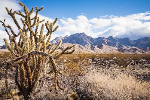

In the mountains, you’ll find a rugged piece of earth with many canyons, winding washes, and bajadas. Elevations range from 2,720 feet on a valley floor to 4,569 feet on a mountain summit. The three dry valleys are dotted with desert shrubs and yucca. Wild burros are protected here, and you’ll probably see a few of them, along with desert bighorn sheep, desert tortoises, and golden eagles.
An old four-wheel-drive track crosses the area from northwest to southeast, and a long waterless way it is. The northeastern border is the Nevada state line.
For more information about this wilderness, please visit Wilderness Connect.
Leave No Trace
How to follow the seven standard Leave No Trace principles differs in different parts of the country (desert vs. Rocky Mountains). For more information on any of the principles listed below, please visit Leave No Trace, Visit the Leave No Trace, Inc. website..
- Plan Ahead and Prepare
- Travel and Camp on Durable Surfaces
- Dispose of Waste Properly
- Leave What You Find
- Minimize Campfire Impacts
- Respect Wildlife
- Be Considerate of Other Visitors
Rules and Regulations
Motorized equipment and equipment used for mechanical transport are generally prohibited on all federal lands designated as wilderness. This includes the use of motor vehicles (including OHVs), motorboats, motorized equipment, bicycles, hang gliders, wagons, carts, portage wheels, and the landing of aircraft including helicopters, unless provided for in specific legislation. In a few areas some exceptions allowing the use of motorized equipment or mechanical transport are described in the special regulations in effect for a specific area. Contact the agency for more information about regulations.
Explore Nearby
- Bureau of Land Management Back Country Byway — Scenic Byway in New Mexico
- South Las Vegas Strip scenic route — Scenic Byway in Nevada
- Old Las Vegas Mormon Fort State Historic Park — State Park in Nevada
- Ice Age Fossils State Park — State Park in Nevada
- Death Valley National Park Dark Sky Park — Dark Sky Site in California
Nearby Discoveries
12 places to explore within 30 miles

Horse Thief Camp – Kingston Mountains, CA
5.5 miles away · 4.7 ★
Horsethief Springs/Cabin
5.5 miles away · 4.7 ★
Mesquite Wilderness
9.7 miles away · 5.0 ★
North Mesquite Mountains Wilderness
11.6 miles away · 2.0 ★
South Nopah Range Wilderness
14 miles away · 4.5 ★
Kingston Range Wilderness
14.9 miles away · 5.0 ★
Nopah Range Wilderness
15.8 miles away · 4.6 ★
This Special Recreation Management Area
23.9 miles away · 4.8 ★
Stateline Wilderness
25.7 miles away · 4.8 ★
Saddle Peak Hills Wilderness
27.9 miles away · 5.0 ★
Clark Mountain Camp
28 miles away · 5.0 ★
