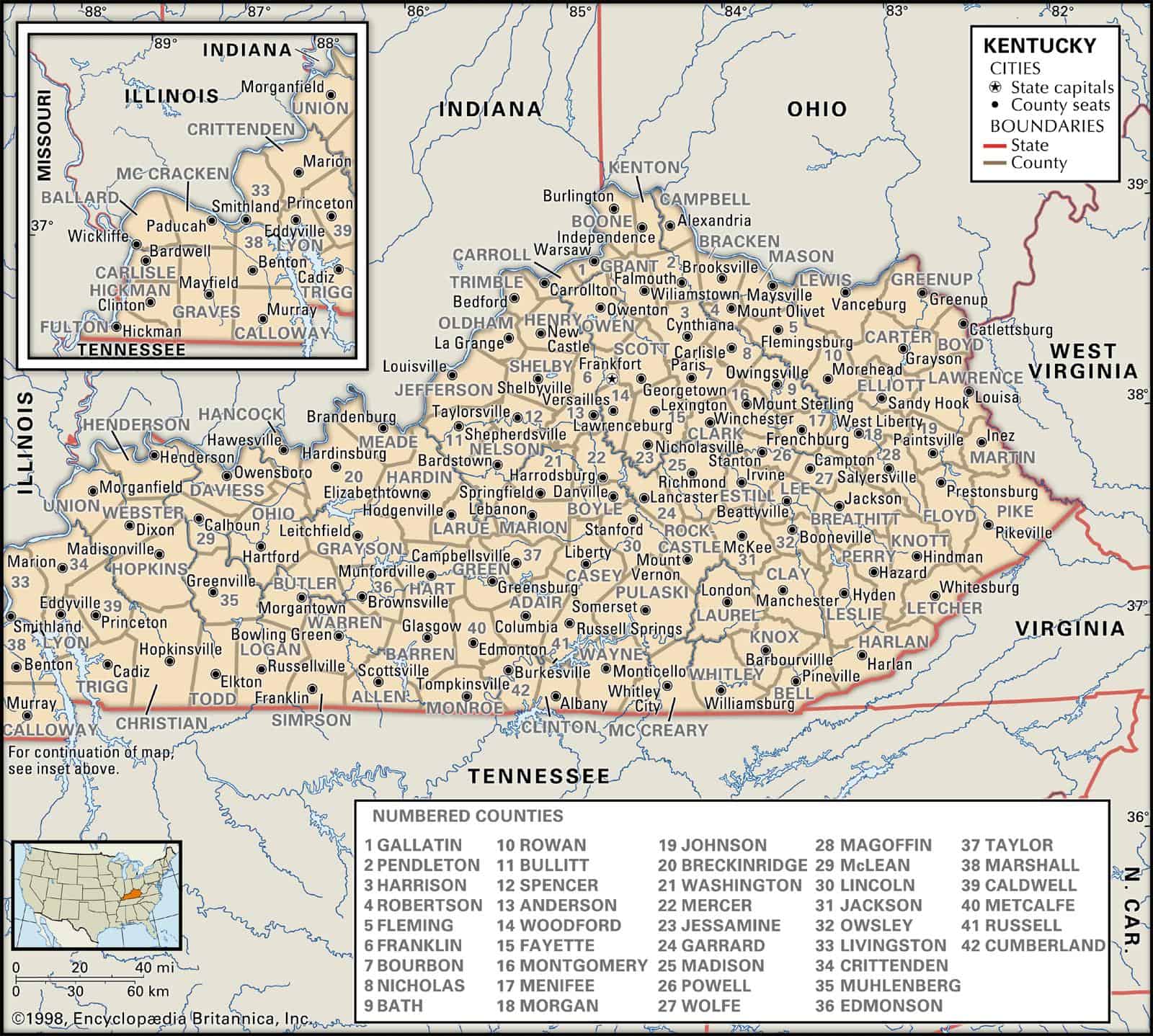
Maps of Kentucky are a vital element when it comes to genealogy and family tree research, particularly in the event that you live far from where your ancestors lived.
Given that Kentucky’s political borders have sometimes changed over the years, historic maps are essential in helping you find out the exact location of your ancestor’s home, what land they owned, just who their neighbors had been, and a lot more besides.
Maps of Kentucky are an excellent way of getting started with your research since they provide you with useful information and facts right away and then present them in a clear and easily understandable format.
Kentucky’s 10 largest cities are Louisville, Lexington-Fayette, Bowling Green, Owensboro, Covington, Hopkinsville, Richmond, Florence, Georgetown, and Henderson.
Learn more about Historical Facts of Kentucky Counties.
Interactive Map of Kentucky County Formation History
AniMap Plus 3.0, with the permission of the Goldbug Company
Kentucky Counties at a Glance
- Total counties: 120 — third-most of any U.S. state
- Oldest county: Lincoln County, established 1780
- Newest county: McCreary County, established 1912
- Largest by area: Pike County (~788 sq mi)
- Most populous: Jefferson County (Louisville metro)
- State capital county: Franklin County (Frankfort)
Why Does Kentucky Have So Many Counties?
One hundred and twenty counties is a lot — and it’s not an accident. When Kentucky was carving itself up in the late 1700s and early 1800s, the working rule was practical: a county had to be small enough that any citizen could ride to the county seat and back home in a single day on horseback. That standard, baked into early Kentucky law, meant the map kept splitting every time a new cluster of settlers pushed further into the mountains or down into the river bottoms. By the time McCreary County was formed in 1912 — the last one — Kentucky had 120 pieces on the board.
The result is a county map that reads almost like a timeline of westward and southward settlement. The oldest counties hug the Bluegrass and the Ohio River. The newest ones are tucked into the eastern coalfields, where Appalachian ridges made travel so difficult that communities needed their own local government just to function. Use the interactive formation map above to watch that process play out — it’s genuinely one of the better ways to understand how Kentucky grew.
If you’re here for genealogy research, that formation history matters more than you might expect. A deed recorded in one county in 1840 might fall inside a completely different county’s jurisdiction today. The Historical Facts of Kentucky Counties resource is worth bookmarking alongside the map.
Kentucky’s Five Geographic Regions — and Their Counties
Kentucky isn’t one landscape. The counties feel different depending on where you are, and grouping them by region helps make sense of the full list.
- Northern Kentucky / Bluegrass: Counties like Boone, Campbell, Kenton, and Grant sit across the Ohio River from Cincinnati and are part of a dense Northern Kentucky metro. Fayette County (Lexington) and the surrounding Bluegrass counties — Bourbon, Clark, Jessamine, Scott, Woodford — are horse-farm country in the most literal sense.
- Central Kentucky: Franklin (Frankfort), Anderson, Mercer, Boyle, and Lincoln counties form the historic core of the state. This is where Kentucky’s earliest political and legal institutions took root.
- Western Kentucky: The Purchase counties — Calloway, Graves, McCracken, Marshall, Carlisle, Hickman, Fulton, and Ballard — occupy the far western tip of the state between the Tennessee River and the Mississippi. Fulton County is so far west it’s actually west of most of Missouri.
- Southern Kentucky: Barren, Warren (Bowling Green), Allen, Simpson, Logan, and their neighbors stretch along the Tennessee border. Edmonson County is home to Mammoth Cave National Park.
- Eastern Kentucky: The Appalachian counties — Breathitt, Floyd, Knott, Leslie, Letcher, Harlan, Perry, Pike, and others — are mountain terrain with deep coal-mining history and some of the most dramatic landscapes in the state. Pike County is Kentucky’s largest county by area.
A Note on Dry, Wet, and Moist Counties
Kentucky uses a local-option system for alcohol sales, which means individual counties — and even individual cities within counties — vote on whether to allow alcohol sales. Counties are generally classified as wet (alcohol sold freely), dry (no retail alcohol sales), or moist (limited sales, often only in restaurants or specific zones). The mix shifts over time as communities hold new elections, so if you need current status for a specific county, check with the Kentucky Department of Alcoholic Beverage Control or the county clerk directly. One fun footnote: Bourbon County — yes, the county the whiskey is named after — has historically been a dry county.
Complete List of Kentucky Counties (Alphabetical)
All 120 counties are listed below in alphabetical order. Each county name links to the Kentucky Transportation Cabinet’s official county road map (PDF). Population figures are approximate, based on recent Census estimates.
| County | County Seat | Est. | Region | Road Map |
|---|---|---|---|---|
| Adair | Columbia | 1801 | South-Central | |
| Allen | Scottsville | 1815 | Southern | |
| Anderson | Lawrenceburg | 1827 | Central | |
| Ballard | Wickliffe | 1842 | Western (Purchase) | |
| Barren | Glasgow | 1798 | Southern | |
| Bath | Owingsville | 1811 | Northeastern | |
| Bell | Pineville | 1867 | Eastern | |
| Boone | Burlington | 1799 | Northern | |
| Bourbon | Paris | 1786 | Bluegrass | |
| Boyd | Catlettsburg | 1860 | Northeastern | |
| Boyle | Danville | 1842 | Central | |
| Bracken | Brooksville | 1796 | Northern | |
| Breathitt | Jackson | 1839 | Eastern | |
| Breckinridge | Hardinsburg | 1800 | Western | |
| Bullitt | Shepherdsville | 1796 | North-Central | |
| Butler | Morgantown | 1810 | Western | |
| Caldwell | Princeton | 1809 | Western | |
| Calloway | Murray | 1822 | Western (Purchase) | |
| Campbell | Alexandria | 1794 | Northern | |
| Carlisle | Bardwell | 1886 | Western (Purchase) | |
| Carroll | Carrollton | 1838 | Northern | |
| Carter | Grayson | 1838 | Northeastern | |
| Casey | Liberty | 1806 | South-Central | |
| Christian | Hopkinsville | 1797 | Western | |
| Clark | Winchester | 1792 | Bluegrass | |
| Clay | Manchester | 1807 | Eastern | |
| Clinton | Albany | 1835 | South-Central | |
| Crittenden | Marion | 1842 | Western | |
| Cumberland | Burkesville | 1798 | South-Central | |
| Daviess | Owensboro | 1815 | Western | |
| Edmonson | Brownsville | 1825 | South-Central | |
| Elliott | Sandy Hook | 1869 | Northeastern | |
| Estill | Irvine | 1808 | Eastern | |
| Fayette | Lexington | 1780 | Bluegrass | |
| Fleming | Flemingsburg | 1798 | Northeastern | |
| Floyd | Prestonsburg | 1800 | Eastern | |
| Franklin | Frankfort | 1795 | Central | |
| Fulton | Hickman | 1845 | Western (Purchase) | |
| Gallatin | Warsaw | 1798 | Northern | |
| Garrard | Lancaster | 1796 | Central | |
| Grant | Williamstown | 1820 | Northern | |
| Graves | Mayfield | 1824 | Western (Purchase) | |
| Grayson | Leitchfield | 1810 | Central | |
| Green | Greensburg | 1792 | South-Central | |
| Greenup | Greenup | 1803 | Northeastern | |
| Hancock | Hawesville | 1829 | Western | |
| Hardin | Elizabethtown | 1792 | Central | |
| Harlan | Harlan | 1819 | Eastern | |
| Harrison | Cynthiana | 1793 | Bluegrass | |
| Hart | Munfordville | 1819 | South-Central | |
| Henderson | Henderson | 1799 | Western | |
| Henry | New Castle | 1798 | Northern | |
| Hickman | Clinton | 1821 | Western (Purchase) | |
| Hopkins | Madisonville | 1806 | Western | |
| Jackson | McKee | 1858 | Eastern | |
| Jefferson | Louisville | 1780 | North-Central | |
| Jessamine | Nicholasville | 1798 | Bluegrass | |
| Johnson | Paintsville | 1843 | Eastern | |
| Kenton | Covington / Independence | 1840 | Northern | |
| Knott | Hindman | 1884 | Eastern | |
| Knox | Barbourville | 1799 | Eastern | |
| Larue | Hodgenville | 1843 | Central | |
| Laurel | London | 1825 | Eastern | |
| Lawrence | Louisa | 1821 | Eastern | |
| Lee | Beattyville | 1870 | Eastern | |
| Leslie | Hyden | 1878 | Eastern | |
| Letcher | Whitesburg | 1842 | Eastern | |
| Lewis | Vanceburg | 1806 | Northeastern | |
| Lincoln | Stanford | 1780 | Central | |
| Livingston | Smithland | 1798 | Western | |
| Logan | Russellville | 1792 | Southern | |
| Lyon | Eddyville | 1854 | Western | |
| Madison | Richmond | 1786 | Bluegrass | |
| Magoffin | Salyersville | 1860 | Eastern | |
| Marion | Lebanon | 1834 | Central | |
| Marshall | Benton | 1842 | Western (Purchase) | Marshall |
| Martin | Inez | 1870 | Eastern | Martin |
| Mason | Maysville | 1789 | Northeastern | Mason |
| McCracken | Paducah | 1824 | Western (Purchase) | McCracken |
| McCreary | Whitley City | 1912 | Eastern | McCreary |
| McLean | Calhoun | 1854 | Western | McLean |
| Meade | Brandenburg | 1823 | Western | Meade |
| Menifee | Frenchburg | 1869 | Eastern | Menifee |
| Mercer | Harrodsburg | 1786 | Central | Mercer |
| Metcalfe | Edmonton | 1860 | South-Central | Metcalfe |
| Monroe | Tompkinsville | 1820 | Southern | Monroe |
| Montgomery | Mount Sterling | 1796 | Bluegrass | Montgomery |
| Morgan | West Liberty | 1822 | Eastern | Morgan |
| Muhlenberg | Greenville | 1798 | Western | Muhlenberg |
| Nelson | Bardstown | 1784 | Central | Nelson |
| Nicholas | Carlisle | 1799 | Bluegrass | Nicholas |
| Ohio | Hartford | 1798 | Western | Ohio |
| Oldham | La Grange | 1823 | Northern | Oldham |
| Owen | Owenton | 1819 | Northern | Owen |
| Owsley | Booneville | 1843 | Eastern | Owsley |
| Pendleton | Falmouth | 1798 | Northern | Pendleton |
| Perry | Hazard | 1820 | Eastern | Perry |
| Pike | Pikeville | 1821 | Eastern | Pike |
| Powell | Stanton | 1852 | Eastern | Powell |
| Pulaski | Somerset | 1798 | South-Central | Pulaski |
| Robertson | Mount Olivet | 1867 | Northeastern | Robertson |
| Rockcastle | Mount Vernon | 1810 | Eastern | Rockcastle |
| Rowan | Morehead | 1856 | Northeastern | Rowan |
| Russell | Jamestown | 1825 | South-Central | Russell |
| Scott | Georgetown | 1792 | Bluegrass | Scott |
| Shelby | Shelbyville | 1792 | Central | Shelby |
| Simpson | Franklin | 1819 | Southern | Simpson |
| Spencer | Taylorsville | 1824 | Central | Spencer |
| Taylor | Campbellsville | 1848 | South-Central | Taylor |
| Todd | Elkton | 1820 | Southern | Todd |
| Trigg | Cadiz | 1820 | Western | Trigg |
| Trimble | Bedford | 1837 | Northern | Trimble |
| Union | Morganfield | 1811 | Western | Union |
| Warren | Bowling Green | 1796 | Southern | Warren |
| Washington | Springfield | 1792 | Central | Washington |
| Wayne | Monticello | 1800 | South-Central | Wayne |
| Webster | Dixon | 1860 | Western | Webster |
| Whitley | Williamsburg | 1818 | Eastern | Whitley |
| Wolfe | Campton | 1860 | Eastern | Wolfe |
| Woodford | Versailles | 1788 | Bluegrass | Woodford |
Road map PDFs link to the Kentucky Transportation Cabinet. Counties without a PDF link in this table (Marshall through Woodford) have road maps available through the Transportation Cabinet’s planning portal — search by county name at transportation.ky.gov.
County-by-County Notes
The table above gives you the quick-reference view. Below are a few regional highlights worth knowing before you dig into the individual county entries.
The Bluegrass Counties
Fayette (Lexington), Bourbon, Clark, Scott, Woodford, Jessamine, and their neighbors form the heart of the Inner Bluegrass — limestone-rich soil, horse farms, and distilleries. Bourbon County is the one that always gets a double-take: yes, the county the whiskey is named after, and yes, it has historically operated as a dry county. The name actually traces back to the French royal house, not the barrel. Woodford County, just west of Lexington, is home to Woodford Reserve’s distillery on Glenn’s Creek — one of the most-visited distillery sites in the state.
Northern Kentucky
Boone, Campbell, and Kenton counties sit directly across the Ohio River from Cincinnati and function as a single metro area in practical terms. Campbell County’s county seat is technically Alexandria, but Newport — right on the river — is the city most people associate with it. Kenton County has two county seats, Covington and Independence, which is unusual enough to be worth noting on a map page.
Eastern Kentucky
The Appalachian counties — Breathitt, Floyd, Harlan, Knott, Knox, Laurel, Lee, Leslie, Letcher, Magoffin, Martin, Morgan, Perry, Pike, Powell, Wolfe, and others — cover the eastern third of the state. Pike County is the largest in Kentucky by area and borders both Virginia and West Virginia. Harlan County has one of the most recognizable names in American labor history. Edmonson County, while technically south-central, is the gateway to Mammoth Cave National Park — the world’s longest known cave system.
Western Kentucky and the Jackson Purchase
The eight counties of the Jackson Purchase — Ballard, Calloway, Carlisle, Fulton, Graves, Hickman, Marshall, and McCracken — occupy the far western tip of the state, bounded by the Tennessee River to the east and the Mississippi to the west. Paducah (McCracken County) is the region’s main city. Fulton County is geographically interesting: it sits so far west that it’s actually west of most of Missouri, and part of it lies in a Mississippi River floodplain that’s physically separated from the rest of Kentucky by the river’s meanders.
Using the County Formation Map for Genealogy
If you’re tracing Kentucky ancestors, the formation animation above is more than a curiosity — it’s a practical research tool. Kentucky’s county boundaries shifted constantly between 1780 and 1912, which means a family that stayed in the same physical location might appear in records for two or three different counties across different decades. Before you search a county courthouse or deed book, it’s worth checking which county actually governed that land at the time your ancestor lived there.
The Historical Facts of Kentucky Counties resource pairs well with the map — it documents parent counties, formation dates, and name changes that can help you trace a records gap. The David Rumsey Historical Map Collection is another strong resource if you want to see what a specific county looked like on a printed map from a particular decade.
Individual County Entries
Each county entry below includes founding date, approximate population, and geographic location. These are organized alphabetically and link to the Kentucky Transportation Cabinet’s official road map PDF where available.
Adair County
Established in 1801 and named for Governor John Adair, Adair County sits in the south-central part of the state with Columbia as its county seat. Population is around 19,000. It’s quiet hill country, carved out of Green County when settlers in the area needed a closer courthouse. Adair County road map (PDF)
Allen County
Founded in 1815, Allen County borders Tennessee in the southern part of the state. Scottsville is the county seat. Population sits around 21,000. The county was named for Colonel John Allen, killed at the Battle of the River Raisin during the War of 1812. Allen County road map (PDF)
Anderson County
Anderson County was founded in 1827 with Lawrenceburg as its seat. Located in central Kentucky between Frankfort and Lexington, it has a population of around 22,000. The county is part of Kentucky’s bourbon trail corridor — Four Roses Distillery operates here along the Salt River. Anderson County road map (PDF)
Ballard County
Established in 1842, Ballard County is one of the eight Jackson Purchase counties in far western Kentucky. Wickliffe is the county seat. With a population of about 8,000, it’s one of the state’s smaller counties by population. The county sits at the confluence of the Ohio and Mississippi rivers — Wickliffe Mounds, a Mississippian-era archaeological site, is located here. Ballard County road map (PDF)
Barren County
Founded in 1798, Barren County takes its name from the barrens — open grasslands that early settlers found when they arrived, likely maintained by Native American burning practices. Glasgow is the county seat, and the population is around 45,000, making it one of the larger south-central counties. Barren County road map (PDF)
Bath County
Bath County was established in 1811, named for the mineral springs in the area that reminded settlers of Bath, England. Owingsville is the county seat. Located in northeastern Kentucky, it has a population of approximately 12,000. Bath County road map (PDF)
Bell County
Founded in 1867, Bell County is tucked into the southeastern corner of Kentucky along the Cumberland Mountains and the Virginia border. Pineville is the county seat. Population is around 26,000. Cumberland Gap National Historical Park sits at the tripoint of Kentucky, Virginia, and Tennessee — partly within Bell County’s reach. Bell County road map (PDF)
Boone County
Established in 1799 and named for Daniel Boone, Boone County is one of the fastest-growing counties in Kentucky. Burlington is the county seat, though the county is effectively part of the greater Cincinnati metro. Population is around 135,000. Boone County road map (PDF)
Bourbon County
Founded in 1786 and named for the French royal house (not the whiskey — though the whiskey is named for the county), Bourbon County sits in the heart of the Bluegrass with Paris as its county seat. Population is approximately 20,000. It’s historically a dry county, which remains one of Kentucky’s more ironic geographic footnotes. Bourbon County road map (PDF)
Boyd County
Boyd County was established in 1860 along the Ohio River in northeastern Kentucky, with Catlettsburg as the county seat. Population is about 46,000. Ashland, the county’s largest city, is a significant Ohio River industrial town. Boyd County road map (PDF)
Boyle County
Founded in 1842, Boyle County is in central Kentucky with Danville as its seat. Population is approximately 30,000. Danville is home to Centre College and was the site of Kentucky’s first constitutional convention in 1792. Boyle County road map (PDF)
Bracken County
Established in 1796, Bracken County sits in northeastern Kentucky along the Ohio River. Brooksville is the county seat. With a population of around 8,000, it’s one of the smaller counties in the state. Bracken County road map (PDF)
Breathitt County
Founded in 1839, Breathitt County is in the heart of eastern Kentucky’s mountains with Jackson as its seat. Population is about 12,000. The North Fork of the Kentucky River runs through the county, and the terrain here is as rugged as anywhere in the state. Breathitt County road map (PDF)
Breckinridge County
Established in 1800, Breckinridge County is in western Kentucky with Hardinsburg as its seat. Population is approximately 20,000. The county is named for Attorney General John Breckinridge, not the Confederate general. Breckinridge County road map (PDF)
Bullitt County
Founded in 1796, Bullitt County is immediately south of Louisville with Shepherdsville as its seat. Population is around 81,000 — it’s grown substantially as a Louisville suburb. Bernheim Arboretum and Research Forest, one of the largest privately owned nature preserves in the eastern U.S., is located here. Bullitt County road map (PDF)
Butler County
Established in 1810, Butler County is in western Kentucky with Morgantown as its seat. Population is about 13,000. The Green River runs through the county. Butler County road map (PDF)
Caldwell County
Founded in 1809, Caldwell County is in southwestern Kentucky with Princeton as its seat. Population is approximately 12,000. The county is part of the Western Coal Field region. Caldwell County road map (PDF)
Calloway County
Established in 1822, Calloway County is one of the Jackson Purchase counties in southwestern Kentucky. Murray is the county seat and home to Murray State University. Population is around 40,000. Kentucky Lake’s eastern shore runs along the county’s eastern edge. Calloway County road map (PDF)
Campbell County
Founded in 1794, Campbell County sits across the Ohio River from Cincinnati. Alexandria is the official county seat, but Newport is the county’s most recognizable city. Population is about 93,000. The county is part of the Northern Kentucky metro area. Campbell County road map (PDF)
Carlisle County
Established in 1886 — one of the later counties to be formed — Carlisle County is in the far western Jackson Purchase with Bardwell as its seat. Population is approximately 4,500, making it one of Kentucky’s smallest. Carlisle County road map (PDF)
Carroll County
Founded in 1838, Carroll County is in northern Kentucky along the Ohio River with Carrollton as its seat. Population is around 10,000. The confluence of the Kentucky River and the Ohio River is at Carrollton — a notable geographic landmark. Carroll County road map (PDF)
Carter County
Established in 1838, Carter County is in northeastern Kentucky with Grayson as its seat. Population is approximately 27,000. Carter Caves State Resort Park, with its network of accessible caverns, is a draw for visitors to this part of the state. Carter County road map (PDF)
Casey County
Founded in 1806, Casey County is in south-central Kentucky with Liberty as its seat. Population is about 16,000. The county sits in a transitional zone between the Bluegrass and the Cumberland Plateau. Casey County road map (PDF)
Christian County
Established in 1797, Christian County is in southwestern Kentucky with Hopkinsville as its seat. Population is around 80,000, making it one of the larger western Kentucky counties. Fort Campbell, which straddles the Kentucky-Tennessee border, is partly in Christian County. Christian County road map (PDF)
Clark County
Founded in 1792, Clark County is in the Bluegrass with Winchester as its seat. Population is approximately 36,000. The county is named for Revolutionary War general George Rogers Clark. Clark County road map (PDF)
Clay County
Established in 1807, Clay County is in southeastern Kentucky with Manchester as its seat. Population is about 19,000. The county sits in the Daniel Boone National Forest corridor. Clay County road map (PDF)
Clinton County
Founded in 1835, Clinton County is in south-central Kentucky with Albany as its seat. Population is approximately 10,000. Lake Cumberland’s southern arm reaches into the county. Clinton County road map (PDF)
Crittenden County
Established in 1842, Crittenden County is in southwestern Kentucky with Marion as its seat. Population is around 9,000. The county was named for Senator John J. Crittenden, known for the Crittenden Compromise proposed on the eve of the Civil War. Crittenden County road map (PDF)
Cumberland County
Founded in 1798, Cumberland County is in south-central Kentucky with Burkesville as its seat. Population is about 6,500. The Cumberland River originates in this region. Cumberland County road map (PDF)
Daviess County
Established in 1815, Daviess County is in western Kentucky with Owensboro as its seat. Population is approximately 102,000 — Owensboro is Kentucky’s fourth-largest city. The county sits along the Ohio River and is known for its barbecue tradition and the International Bluegrass Music Museum. Daviess County road map (PDF)
Edmonson County
Founded in 1825, Edmonson County is in south-central Kentucky with Brownsville as its seat. Population is around 12,000. Mammoth Cave National Park — the world’s longest known cave system — is located here, making Edmonson one of the most geologically significant counties in the state. Edmonson County road map (PDF)
Elliott County
Established in 1869, Elliott County is in northeastern Kentucky with Sandy Hook as its seat. Population is approximately 7,500. It’s one of the more rural and isolated counties in the state, tucked into the hills east of Morehead. Elliott County road map (PDF)
Estill County
Founded in 1808, Estill County is in eastern Kentucky with Irvine as its seat. Population is about 14,000. The Red River Gorge is nearby in neighboring Powell and Menifee counties, and Estill County sits at the western edge of the Daniel Boone National Forest. Estill County road map (PDF)
Fayette County
Established in 1780, Fayette County is one of Kentucky’s oldest and most populous, with Lexington as both the county seat and a consolidated city-county government. Population is around 336,000. The county is the center of the Thoroughbred horse industry, home to Keeneland Race Course and dozens of working horse farms on the Inner Bluegrass limestone. Fayette County road map (PDF)
Fleming County
Founded in 1798, Fleming County is in northeastern Kentucky with Flemingsburg as its seat. Population is approximately 14,500. The county is largely agricultural, sitting between the Bluegrass and the Ohio River hills. Fleming County road map (PDF)
Floyd County
Established in 1800, Floyd County is in southeastern Kentucky with Prestonsburg as its seat. Population is about 36,000. The Big Sandy River forms the county’s eastern border with West Virginia. Prestonsburg is the site of the Jenny Wiley State Resort Park. Floyd County road map (PDF)
Franklin County
Founded in 1795, Franklin County is in north-central Kentucky and includes Frankfort, the state capital. Population is around 50,000. The Kentucky State Capitol building and the Kentucky History Center are both in Frankfort, making this county a natural starting point for anyone researching state records. Franklin County road map (PDF)
Fulton County
Established in 1845, Fulton County is Kentucky’s westernmost county, with Hickman as its seat. Population is approximately 6,500. The county is geographically unusual — part of it sits in a Mississippi River floodplain physically separated from the rest of Kentucky by the river’s meanders, making it technically an exclave. It’s one of the more interesting boundary quirks on the Kentucky map. Fulton County road map (PDF)
Gallatin County
Founded in 1798, Gallatin County is in northern Kentucky along the Ohio River with Warsaw as its seat. Population is around 9,000. The county is named for Albert Gallatin, Secretary of the Treasury under Presidents Jefferson and Madison. Gallatin County road map (PDF)
Garrard County
Established in 1796, Garrard County is in central Kentucky with Lancaster as its seat. Population is about 18,500. The county is named for James Garrard, Kentucky’s second governor. Garrard County road map (PDF)
Grant County
Founded in 1820, Grant County is in northern Kentucky with Williamstown as its seat. Population is approximately 25,000. The Ark Encounter attraction in Williamstown draws significant visitor traffic to the county. Grant County road map (PDF)
Graves County
Established in 1824, Graves County is in the Jackson Purchase with Mayfield as its seat. Population is around 36,000. The county is one of the larger Purchase counties and an agricultural hub for western Kentucky. Graves County road map (PDF)
Grayson County
Founded in 1810, Grayson County is in central Kentucky with Leitchfield as its seat. Population is about 27,000. Rough River Lake, a U.S. Army Corps of Engineers reservoir, is a recreational draw in the county. Grayson County road map (PDF)
Green County
Established in 1792, Green County is in south-central Kentucky with Greensburg as its seat. Population is approximately 11,000. The Green River, which flows through Mammoth Cave National Park downstream, originates in this region. Green County road map (PDF)
Greenup County
Founded in 1803, Greenup County is in northeastern Kentucky along the Ohio River with Greenup as its seat. Population is around 35,000. Ashland (in adjacent Boyd County) is the regional center, but Greenup County has its own Ohio River frontage and industrial history. Greenup County road map (PDF)
Hancock County
Established in 1829, Hancock County is in western Kentucky along the Ohio River with Hawesville as its seat. Population is approximately 8,500. It’s one of the smaller Ohio River counties, sandwiched between Daviess and Breckinridge. Hancock County road map (PDF)
Hardin County
Founded in 1792, Hardin County is in north-central Kentucky with Elizabethtown as its seat. Population is about 110,000. Fort Knox — home to the U.S. Bullion Depository — is in Hardin County. Abraham Lincoln’s birthplace at Sinking Spring Farm is in neighboring Larue County, but the Lincoln heritage corridor runs through this area. Hardin County road map (PDF)
Harlan County
Established in 1819, Harlan County is in southeastern Kentucky with Harlan as its seat. Population is around 26,000. The county has one of the most documented histories of any in Appalachia, tied closely to coal mining and labor organizing in the 20th century. Black Mountain, the highest point in Kentucky at 4,145 feet, is in Harlan County. Harlan County road map (PDF)
Harrison County
Founded in 1793, Harrison County is in northern Kentucky with Cynthiana as its seat. Population is approximately 19,000. The county saw Civil War action at the Battle of Cynthiana in 1864. Harrison County road map (PDF)
Hart County
Established in 1819, Hart County is in south-central Kentucky with Munfordville as its seat. Population is around 19,000. Munfordville was the site of a significant Civil War engagement in 1862 when Confederate forces under Braxton Bragg captured the Union garrison there. Hart County road map (PDF)
Henderson County
Founded in 1799, Henderson County is in western Kentucky along the Ohio River with Henderson as its seat. Population is approximately 46,000. John James Audubon lived in Henderson for several years and did much of his bird observation work here — the John James Audubon State Park preserves that history. Henderson County road map (PDF)
Henry County
Established in 1798, Henry County is in northern Kentucky with New Castle as its seat. Population is around 16,000. The county is named for Patrick Henry. Henry County road map (PDF)
Hickman County
Founded in 1821, Hickman County is one of the Jackson Purchase counties in far western Kentucky with Clinton as its seat. Population is approximately 4,700, making it one of the state’s least populous counties. The Mississippi River forms its western border. Hickman County road map (PDF)
Hopkins County
Established in 1806, Hopkins County is in western Kentucky with Madisonville as its seat. Population is around 45,000. The county was historically a coal-producing center in the Western Coal Field. Hopkins County road map (PDF)
Jackson County
Founded in 1858, Jackson County is in eastern Kentucky with McKee as its seat. Population is about 13,000. The county is part of the Daniel Boone National Forest territory. Jackson County road map (PDF)
Jefferson County
Established in 1780, Jefferson County is one of Kentucky’s original counties and its most populous. Louisville is both the county seat and a consolidated city-county government (Louisville Metro). Population is over 780,000. The county anchors the Louisville metro area on the Ohio River and is home to Churchill Downs, the Louisville Slugger Museum, and the Muhammad Ali Center. Jefferson County road map (PDF)
Jessamine County
Founded in 1798, Jessamine County is in the Bluegrass with Nicholasville as its seat. Population is approximately 54,000. The county is immediately south of Lexington and has grown significantly as part of the Lexington metro. The Palisades of the Kentucky River — dramatic limestone cliffs along the river gorge — run along the county’s northern edge. Jessamine County road map (PDF)
Johnson County
Established in 1843, Johnson County is in eastern Kentucky with Paintsville as its seat. Population is about 22,000. The county is in the Big Sandy River valley and has a strong coal and country music heritage — Loretta Lynn was born in neighboring Johnson County territory. Johnson County road map (PDF)
Kenton County
Founded in 1840, Kenton County is in northern Kentucky across from Cincinnati with two county seats — Covington (the historic seat) and Independence (the current administrative center). Population is approximately 170,000, making it one of the state’s most populous. Covington’s MainStrasse Village and the Roebling Suspension Bridge (a prototype for the Brooklyn Bridge) are landmarks here. Kenton County road map (PDF)
Knott County
Established in 1884, Knott County is in eastern Kentucky with Hindman as its seat. Population is around 15,000. Hindman Settlement School, founded in 1902, is one of the oldest settlement schools in Appalachia and remains active. Knott County road map (PDF)
Knox County
Founded in 1799, Knox County is in southeastern Kentucky with Barbourville as its seat. Population is approximately 31,000. The county is named for General Henry Knox, first U.S. Secretary of War. Knox County road map (PDF)
LaRue County
Established in 1843, LaRue County is in central Kentucky with Hodgenville as its seat. Population is about 14,000. Abraham Lincoln was born at Sinking Spring Farm in LaRue County — the Abraham Lincoln Birthplace National Historical Park is here. LaRue County road map (PDF)
Laurel County
Founded in 1825, Laurel County is in eastern Kentucky with London as its seat. Population is approximately 62,000, making it one of the larger eastern Kentucky counties. Interstate 75 runs through the county, and London is a significant commercial hub for the region. Laurel County road map (PDF)
Lawrence County
Established in 1821, Lawrence County is in eastern Kentucky along the West Virginia border with Louisa as its seat. Population is about 15,000. The Tug Fork of the Big Sandy River forms the border with West Virginia. Lawrence County road map (PDF)
Lee County
Founded in 1870, Lee County is in eastern Kentucky with Beattyville as its seat. Population is approximately 7,000. The Three Forks of the Kentucky River — the North, Middle, and South forks — converge near Beattyville, making it a notable geographic landmark. Lee County road map (PDF)
Leslie County
Established in 1878, Leslie County is in eastern Kentucky with Hyden as its seat. Population is around 10,000. The county is deep in the Cumberland Mountains and is one of the more remote counties in the state. Leslie County road map (PDF)
Letcher County
Founded in 1842, Letcher County is in southeastern Kentucky with Whitesburg as its seat. Population is approximately 22,000. Whitesburg is home to Appalshop, a nationally recognized arts and media center documenting Appalachian culture. Letcher County road map (PDF)
Lewis County
Established in 1806, Lewis County is in northeastern Kentucky along the Ohio River with Vanceburg as its seat. Population is about 13,000. The county is named for Meriwether Lewis of the Lewis and Clark Expedition. Lewis County road map (PDF)
Lincoln County
Founded in 1780, Lincoln County is Kentucky’s oldest county, established the same year as Jefferson and Fayette. Stanford is the county seat. Population is approximately 24,000. The county is in central Kentucky and was named for General Benjamin Lincoln of the Revolutionary War — not Abraham Lincoln, who wasn’t born until 1809. Lincoln County road map (PDF)
Livingston County
Established in 1798, Livingston County is in western Kentucky at the confluence of the Cumberland and Tennessee rivers with Smithland as its seat. Population is around 9,000. The county sits at a strategically significant river junction that was contested during the Civil War. Livingston County road map (PDF)
Logan County
Founded in 1792, Logan County is in southern Kentucky with Russellville as its seat. Population is approximately 27,000. The county was an early frontier settlement area and was known as “Rogues’ Harbor” in its earliest days due to its lawless reputation. Logan County road map (PDF)
Lyon County
Established in 1854, Lyon County is in western Kentucky with Eddyville as its seat. Population is about 8,000. Lake Barkley and Kentucky Lake nearly surround the county, making it a peninsula of sorts — a geographic quirk that makes Lyon County one of the more visually striking on the map. Lyon County road map (PDF)
Madison County
Founded in 1786, Madison County is in the Bluegrass with Richmond as its seat. Population is approximately 93,000. Eastern Kentucky University is in Richmond. The county is one of the older Bluegrass counties and was a significant settlement hub in the late 1700s. Madison County road map (PDF)
Magoffin County
Established in 1860, Magoffin County is in eastern Kentucky with Salyersville as its seat. Population is around 12,000. The county is in the Licking River headwaters area, deep in the eastern mountains. Magoffin County road map (PDF)
Marion County
Founded in 1834, Marion County is in central Kentucky with Lebanon as its seat. Population is approximately 20,000. The county is part of the Kentucky Bourbon Trail — Maker’s Mark Distillery is in neighboring Washington County, and several distilleries operate in the region. Marion County road map (PDF)
Further Research
If you’re digging into Kentucky county history for genealogy or just geographic curiosity, a few resources are worth bookmarking:
- Historical Facts of Kentucky Counties — formation dates, parent counties, and name changes organized by county
- David Rumsey Historical Map Collection — searchable archive of historical Kentucky maps by decade
- Goldbug Company — makers of AniMap Plus, the software behind the county formation animation on this page
For printable county road maps, the Kentucky Transportation Cabinet’s planning portal has PDFs for all 120 counties — linked individually in the table above where available.