Salt air hits your face as you pull onto the Pacific Coast Highway, the ocean unfurling on your right and cliffside turns on your left. The drive from San Francisco to Santa Barbara slices through surf towns, state parks, and viewpoints that make you want to stop every few miles.
This guide gives you a practical, five-day driving itinerary with specific stops, timing, parking notes, and what to skip so you waste less time and see more coast. You’ll get short daily plans that focus on what to do, how long to hang, and the small details that make a road day smooth.
1) Day 1: San Francisco to Half Moon Bay — Devil’s Slide and Pillar Point for seals
Salt air hits you first, sharp with kelp and diesel from the highway. Walk the Devil’s Slide Trail and you see waves crashing on black rocks below and old concrete bunkers half buried in grass.
Spend 45–75 minutes here. Walk a mile or two north from the trailhead for better views. Parking fills early on weekends; arrive before 10 a.m. to find a spot and avoid cellphone photos that block the railing.
Pillar Point feels louder — boat horns, gulls, and the smell of wet fish near the marina. Check the seal colony on the rocks by the jetty; binoculars help. Eat a sandwich on the harbor wall or grab coffee from the nearby café.
Skip the souvenir shops if you want to keep moving. If you have time, watch a sunset from the bluff; the light changes fast and the seals get active at dusk.
2) Day 2: Half Moon Bay to Santa Cruz — Davenport and Natural Bridges State Park
Salt air hits first, with gull calls and the hiss of surf as you pull off Highway 1 near Davenport. Walk on the bluff trail to see layered cliffs and a small harbor; spend 30–45 minutes here. Parking is limited at the pullouts, so arrive midmorning or late afternoon to avoid crowds.
At Natural Bridges State Park you smell the wet sand and see the tidal pool life up close. Plan 1–2 hours for the beach, the monarch grove (seasonal), and the short trails to the bridge rock. There’s a small day-use fee and a modest parking lot; sunset brings the best light and more people.
If you like tide pools, bring low shoes and a tide chart. Skip the overpriced snacks nearby and pack water and lunch from town. Park legally—tickets matter—and expect locals on bikes and families with kids at the bridge. My vote: time your visit for low tide and sunset if you can.
3) Day 3: Santa Cruz to Monterey — Capitola Village and the Santa Cruz Surfing Museum
Salt air hits you first, with gull calls and the slap of small waves on the esplanade. Walk the Capitola beachfront for 30–60 minutes to see colorful houses and people paddleboarding. Park on the street early; spaces fill by late morning on weekends.
Visit the Santa Cruz Surfing Museum for 30–45 minutes to read old surfboards and see the lighthouse view. The museum is free, but parking is metered nearby; mornings are quieter and sunnier for photos. Skip long guided tours unless you like deep local lore.
Stroll the Capitola Village shops and grab a bite at a clam chowder window. This stretch moves slow; plan for 2–3 hours total if you want a relaxed lunch and a museum stop. Bring a light jacket—coastal wind picks up in the afternoon.
4) Day 4: Monterey to Big Sur — 17-Mile Drive and Point Lobos State Natural Reserve
Salt air and sea lions bark greet you before the road curves; you’ll smell kelp and hear surf on the rocks. Drive the 17-Mile Drive slowly and stop at Pebble Beach and the Lone Cypress viewpoint for short walks and easy overlooks. Expect tolls and parking fees; plan 1–2 hours if you only want the highlights.
At Point Lobos, walk the Cypress Grove and South Shore trails to see tidepools and coastal scrub. Spend 2–3 hours to explore trails and photograph the coves; parking fills early, so arrive at opening for easier spots. Carry water, wear sturdy shoes, and avoid cliff edges.
Skip long beach swims here—the water is cold and currents are strong. If you value quiet hikes and close-up marine life, leave time for both the drive and the reserve; start early to beat the crowds.
5) Day 5: Big Sur highlights — Bixby Creek Bridge, Pfeiffer Beach, and McWay Falls
Salt spray and surf hit your face as you park near Bixby Creek Bridge and step onto the turnout. Walk the short shoulder for different angles and take 15–30 minutes. Parking is limited; arrive early or late afternoon and avoid weekend mid-day.
At Pfeiffer Beach you hear waves crash through the arch and smell damp sand. Expect a rough, narrow access road and a $12 parking fee at the gate. Spend 30–45 minutes walking the sand, but skip the rocks at high tide — they’re slippery.
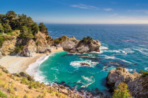
McWay Falls delivers the sound of the fall and cedar-smoke air from nearby trees. The paved overlook trail takes 10–20 minutes round-trip and has no beach access, so plan for photos from above. Park at Julia Pfeiffer Burns State Park and pay the day use fee.
Bring layers, sturdy shoes, and patience for parking; Big Sur moves at its own pace.
6) Day 6: Big Sur to Cambria — Ragged Point and the Elephant Seal Vista Point
Salt air and surf hit you first when you step out at Ragged Point; you’ll hear gulls and the distant roar of waves far below. Walk the short cliff trail for 15–30 minutes to see the coastal drop and wildflowers in season. Parking fills fast on sunny mornings; arrive early or late afternoon to avoid crowds and the small day-use fee.
At Elephant Seal Vista Point you’ll smell the seals before you see them — that tells you you’re close. Spend 20–40 minutes watching males bellow and females haul out on the sand; the viewing area is fenced and easy to use. There’s no charge, but the boardwalk can be slippery after rain, so wear grippy shoes.
If you have time, drive slowly down the coast road toward Cambria and stop at viewpoints along the way. Bring binoculars and water, and leave room in your schedule for slow driving and photo stops.
7) Day 7: Cambria to San Simeon to Morro Bay — Hearst Castle view stop and Morro Rock
Salt air and gull calls hit you before you see anything, especially near San Simeon where the cliffs drop into foam. Park at the overlook for a quick view of Hearst Castle across the valley—no tour required to enjoy the architecture from below. Spend 15–30 minutes here; parking is limited on busy mornings.
Walk a short trail down to the beach if you want closer surf sounds and whale-watch silence in season. Guided tours of Hearst Castle take several hours and cost extra, so skip them if you’re on a tight schedule.
Pull into Morro Bay and smell kelp and diesel near the harbor. Walk the Embarcadero for 30–60 minutes and circle Morro Rock for good tidepool views; parking is meter-based and fills by noon. If you only have time for one stop, choose the harbor walk over a long castle tour.
8) Day 8: Morro Bay to Pismo Beach — Oceano Dunes and the Pismo Pier clam chowder spot
Salt air hits first, with gulls calling and dune grass rubbing when you step out of the car. Drive the short stretch to Oceano Dunes to hear the engines and smell warm sand; you can ride an ATV if you booked in advance or walk the hard-packed beach for about 1–2 hours.
At Pismo Pier you’ll smell clam chowder before you see the line. Eat at a counter-service place under the pier for a hot bowl; plan 30–45 minutes for food and a quick walk on the pier. Parking is metered and fills up midday, so go early or late afternoon.
If you prefer quieter sand, skip the ATV staging areas and walk south along the shore. Watch for shifting dunes and obey signage; permits are needed for vehicles. Try the chowder at the pier spot if you want a classic, seaside bowl.
9) Day 9: Pismo to Solvang — Avila Hot Springs detour and Solvang Danish bakeries
You smell sulfur and sea salt as you pull into Avila Hot Springs; steam rises from small pools near the parking area. Soak for 45–90 minutes to loosen up after several days on the road. Note: there’s a small fee and limited parking, arrive midmorning to avoid crowds.
Drive the short coastal backroads into Solvang, where oven heat and buttered pastry scents hit you on foot. Spend 1–2 hours walking the main street, sampling aebleskiver and kringle at two bakeries. Park at a municipal lot; meters run until evening and some bakeries take cash only.
Skip long museum tours and stick to tasting and people-watching in the town square. Try one savory pastry and one sweet; split portions so you can try more. My advice: bring a small cooler for leftovers and buy fewer souvenirs than you think.
10) Day 10: Solvang to Santa Barbara — Mission Santa Barbara and Butterfly Beach sunset
You step out and smell salt and eucalyptus as you walk the Mission’s courtyard. Spend 45–60 minutes touring the grounds, museum, and church to see old tiles and carved wood. Park in the lot across the street; there’s a small entry fee for the museum but the church is free.
After the mission, drive down to Butterfly Beach for sunset. Arrive an hour before sunset to find a spot and walk the bluff trail; plan 30–60 minutes. Street parking fills fast on weekends, so aim for late afternoon on weekdays if you want a calmer scene.
If you like coffee, stop at a nearby café on State Street before heading west. Watch the sun drop behind the islands and keep an eye on strong rip currents if you wade — the swim looks easy but can turn rough quickly.
11) Day 11: Santa Barbara to Ventura — Carpinteria Bluffs and local surf breaks
Salt air hits first, sharp with kelp and motor oil from the pier. Walk the Carpinteria Bluffs Trail and you’ll see pelicans, low cliffs, and houses set back from the edge. Spend 45–90 minutes for the bluff path and tidepools if the tide’s low.
Park at Carpinteria State Beach lot; it fills by late morning and has meters. Check tide charts before you get out of the car — low tide opens the rock pools and makes the surf breaks more interesting to watch.
Watch local surfers at Rincon or Carpinteria City Beach if conditions suit; they paddle early and late to avoid crowds. Bring a light jacket; the afternoon sea breeze cools fast. Plan to skip the crowded main beach on summer weekends unless you want people-watching.
If you surf, scope the breaks from the bluff first and don’t paddle out into unfamiliar rip currents.
12) Day 12: Ventura to Malibu — Channel Islands boat option and Point Mugu State Park
Salt air hits you first when the Ventura marina comes into view, with gull calls and the hum of diesel. Catch the Ventura Harbor commuter boat to Santa Cruz Island if you want a half- to full-day escape; plan 4–8 hours, book in advance, and bring water and a windbreaker because shade is scarce. Tickets and parking fill fast on weekends, and the island trails can be rocky so wear sturdy shoes.
If you skip the boat, drive the PCH toward Point Mugu State Park and smell the sage as you drop down to the beach. Walk the short Mugu Rock trail or the gentle La Jolla Canyon loop for 1–2 hours; parking is small, arrive early to snag a spot. Swimming is cold and rips are common; stick to shore walks and tidepooling.
If you want a quick lunch, stop at Ventura’s main strip before heading west; parking is easier there than near the park. Bring cash or a card for park day-use fees and expect strong sun even on cool days. Pack layers and leave extra time for coastal traffic; it moves slow but shows you the best views.
13) Day 13: Malibu to Santa Monica — Zuma Beach then the Getty Villa detour
Salt air hits first, then the steady roar of waves as you step onto Zuma Beach. Walk the wide sand for 30–60 minutes, swim if the rip currents aren’t strong, and watch surfers near the lifeguard towers. Parking fills fast on weekends; arrive before 9 a.m. or use one of the paid lots along Pacific Coast Highway.
From Zuma, drive the scenic spine toward the Getty Villa; you’ll see olive trees and villas through the windows. Reserve Getty Villa tickets in advance and plan 90–120 minutes to stroll the Roman-style gardens and galleries. Note: parking at the Villa is metered and they enforce entry times, so don’t be late.
If you’re short on time skip the full museum tour and sit on the bluff for views of the coastline instead. Expect light traffic as you approach Santa Monica in the afternoon; time the jump onto the 1 to avoid the evening crawl.
Visit the bluff for a final ocean view before heading into Santa Monica.
14) Day 14: Santa Monica to Long Beach — Venice Boardwalk early-morning stroll and Shoreline Village
Salt air and skateboard wheels click on planks as you arrive at Venice Boardwalk before most vendors set up. Walk the boardwalk for 30–60 minutes to catch murals, street performers warming up, and the Muscle Beach rings without the crowds. Park on side streets early; meters start mid-morning and lots fill fast.
Drive down to Long Beach for Shoreline Village next, a 45–90 minute stop to stretch legs and grab coffee. Walk the pier, scan the harbor for boats, and skip the pricey tourist shops if you want real food — head for the small seafood windows. Parking is paid but plentiful; go midweek or early morning for easier spots.
If you have time, add a quick stop at the nearby Aquarium of the Pacific, but budget an extra two hours. Arrive early and buy tickets online to save waiting in line. My honest tip: Venice before sunrise, Shoreline before noon.
15) Day 15: Long Beach to Laguna Beach — Catalina Island ferry option and Heisler Park
Salt air mixes with boat diesel as you dock in Long Beach; gulls cry overhead and you smell frying fish from nearby stands. Walk the waterfront for 30–60 minutes, checking ferry schedules at the terminal if you want a half-day on Catalina Island. Ferries run from Long Beach to Avalon in about an hour; expect ticket lines and parking fees near the terminal.
If you skip Catalina, drive south to Laguna Beach and park near Heisler Park. Spend 45–90 minutes walking the bluff paths, watching tide pools, and snapping views of coves. Metered street parking fills fast on weekends; early morning or late afternoon is best for light and fewer people.
Bring water, layers for coastal wind, and comfortable shoes for rocks and stairs. If you plan Catalina, reserve ferry tickets and Avalon transport in advance. Pick Heisler Park for a short, reliable seaside stop if you want a clean walk and real ocean views.
16) Day 16: Laguna Beach to Dana Point — Salt Creek Beach and the Lantern District
Salt air and sun hit your face as you step onto Salt Creek Beach; you’ll hear steady surf and distant kids playing. Walk the packed sand for 30–60 minutes to see tide pools and surfers near the reef. Bring layers—the ocean breeze chills faster than the parking lot feels.
Drive five minutes south to the Lantern District in Dana Point for coffee, casual seafood, and window shopping. Plan 1–2 hours if you want a short meal and to browse the small shops. Street parking is limited; use the municipal lot near the harbor or arrive before noon.
If you like quieter beaches, pick Salt Creek early morning; the afternoon fills with locals and surfers. Skip the big weekend events unless you want crowds and tight parking. Park legally or you’ll pay a steep ticket.
17) Day 17: Dana Point to San Clemente — San Clemente Pier and Trestles surf check
Salt air hits first, with gull calls and the thump of surf on pilings as you step onto the pier. Walk out for five minutes to see the reef line where surfers paddle and judge conditions.
Scan Trestles from the pier or lower your car window at the beach access lot to hear the surf and watch board traffic. Spend 30–60 minutes if you want a good look; longer if you plan to surf. Parking fills fast on weekends; use the paid lots near Avenida Pico or park in town and walk down.
No organized facilities on the sand except portable restrooms and a single lifeguard tower in season, so bring water and shade. Early morning gives cleaner lines and fewer surfers; midafternoon shifts wind onshore. If you plan to surf, check local surf reports and respect the lineup — crowded peaks get tense fast.
Wayfinding Along the Coast
Salt air, gull calls, and the subtle tilt of cliffs set the pace. You’ll need simple rules: follow major signs, plan for slow traffic, and pick a few real stops so you’re not chasing every view.
How to Navigate the Route Without Losing Your Mind
You’ll hear waves and tire noise as you pull onto the PCH. Pick a primary navigation app (Google Maps or Waze) and download offline maps for the stretch from Malibu to Monterey. Set the route to avoid freeways when you want the coast; switch to fastest route if time’s tight.
Plan one main stop every 45–90 minutes. That keeps you moving and lets you enjoy each place. Watch for narrow shoulders and slow RVs—give yourself extra time in Big Sur and around beach towns during weekends. Parking can be limited: look for designated lots, and expect to pay in popular areas like Santa Monica and Carmel. If a turnoff has a small dirt lot, check for signs about closures before you park.
Bring a paper map as backup and note mile markers for key exits. If you get stuck behind slower cars, use pullouts to pass safely when the road allows. Stick to these habits and you’ll spend less time rerouting and more time on the coast.
Scenic Pullouts Versus Old-School Detours
When you smell diesel or see a cluster of cars, that’s usually a proper pullout. Use pullouts for quick photos (5–15 minutes) and short walks. Good pullouts often sit at obvious viewpoints—watch for signs that say “Scenic View” or show an overlook symbol. Park fully in marked spots; some have limited space and towing is real.
Old-school detours—small state parks, pier towns, and river mouths—need more time. Plan 45–90 minutes for places like Point Lobos or Pismo Beach Pier. These stops give trails, picnic spots, and small-town food. Check hours and parking fees ahead. Town detours can add 30–60 minutes of driving through slower streets.
Choose pullouts when you’re on a tight schedule; pick detours when you want a proper break.
Packing and Practicalities for Five Days
You will face fog, sun, wind, and drizzle in the same afternoon. Plan clothing, gear, and bookings so you can stop when a view shows up and move on when it rains.
What to Bring for Weather That Changes Hourly
You smell salt and see the fog roll in from the ocean when you park. Pack layers: a lightweight fleece, a windproof shell, and a thin waterproof jacket you can fold into a daypack. Bring a wide-brim hat and a knit beanie — sun then stiff wind can both happen in thirty minutes.
Footwear matters. Wear trail shoes or waterproof sneakers for short hikes and rocky beaches. Toss in a pair of flip-flops for motels and quicker stops. Carry a small umbrella but rely more on the shell and hat when wind picks up.
Protect electronics. Use a dry bag for cameras, phone, and maps. Bring an external battery and a car charger. Pack sunscreen and SPF lip balm even on cloudy days; sun reflects off wet sand and water.
Booking Motels Versus Playing It by Ear
You hear late-night surf through thin motel walls and know the draw of a spontaneous stop. Book a few key nights ahead in Monterey or Pismo Beach if you want a guaranteed room and a safe place to leave gear. Use motel apps to snag last-minute deals for smaller towns.
For the middle nights, you can play it by ear if you’re traveling in low season or on weekdays. Arrive before 6 p.m. to avoid sold-out lists. Have a backup plan: a campground or a chain hotel that accepts late check-ins. Always keep a photo of your confirmation and the motel phone number offline.
If you have one must-stop town on your route, reserve that night. Otherwise, stay flexible where motels are plentiful and firm up stands where demand spikes on weekends.