Wisconsin has 66 state parks, forests, and recreation areas managed by the DNR — and if you’re trying to figure out which ones are actually worth your time, a raw alphabetical list doesn’t help much. This guide pairs an interactive map with honest, specific notes on the parks that get the most visitors, the ones that are genuinely underrated, and the practical stuff you need to know before you go (like which parks book out months in advance).
Printable Wisconsin State Parks Map
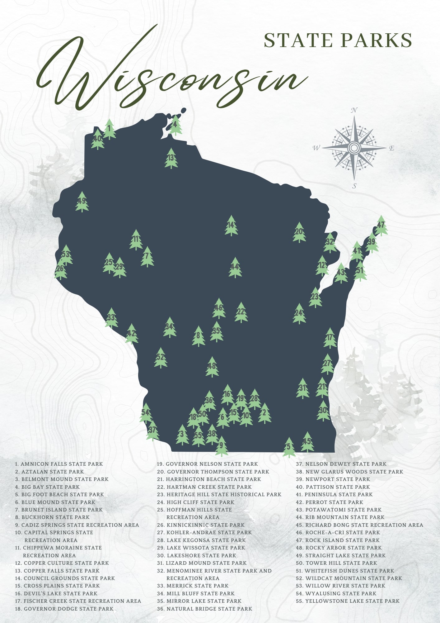
The map above shows the full spread of state parks across Wisconsin. One thing that jumps out: the parks cluster heavily in three zones — the Driftless Area in the southwest, the Door Peninsula in the northeast, and the Lake Superior shoreline up north. If you’re planning a road trip, it’s worth building your route around one of those corridors rather than trying to hit parks scattered across the whole state.
Wisconsin State Parks Vehicle Admission Pass
To enter any Wisconsin state park, you need either a daily vehicle sticker or an annual state parks pass. The annual pass covers unlimited day-use entries for one vehicle and is typically the better deal if you’re visiting more than two or three parks in a year. Camping fees are separate and paid at the time of reservation. For current pricing and to purchase a pass, check the Wisconsin DNR website directly — prices are updated periodically.
Planning to Camp? Start Here
Camping in Wisconsin state parks runs the range from full-hookup sites at busy lakefront parks to primitive backpack sites at Newport State Park where you won’t hear another tent zipper all night. A few things worth knowing before you book:
- Reservations go fast at the popular parks. Devil’s Lake, Peninsula, and Mirror Lake fill up weeks — sometimes months — ahead for summer weekends. If you’re flexible on dates, weeknights in June or September are much easier to book.
- Book through Wisconsin’s reservation system at wisconsin.goingtocamp.com. You can filter by park, site type, and amenities.
- Some parks have walk-in or canoe-in sites that get overlooked in the online search. Buckhorn and Newport both have options worth checking if the main campground is full.
- Year-round camping is available at several parks, including Devil’s Lake and Governor Dodge — useful if you’re into winter camping or shoulder-season hiking.
Wisconsin State Parks at a Glance
Here’s a quick-reference overview of some of the most notable state parks in Wisconsin, organized roughly by region. This isn’t every park — the full list runs to 66 properties — but it covers the ones most visitors are actually choosing between.
| Park | Region | Camping | Best For | Plan Ahead? |
|---|---|---|---|---|
| Devil’s Lake | South-Central | Yes | Hiking, swimming, rock climbing | ⚠️ Book months ahead |
| Peninsula | Door County | Yes | Scenic drives, kayaking, fall color | ⚠️ Book months ahead |
| Mirror Lake | South-Central | Yes | Canoeing, sandstone cliffs, family camping | ⚠️ Book early for summer |
| Newport | Door County | Backpack/canoe-in only | Dark skies, solitude, Lake Michigan shore | Moderate demand |
| Governor Dodge | Southwest | Yes | Horseback riding, hiking, winter snowmobiling | Moderate demand |
| Copper Falls | North | Yes | Waterfalls, gorge hiking | Lower demand |
| Big Bay | Madeline Island / North | Yes | Lake Superior beach, old-growth forest | Ferry required to island |
| Amnicon Falls | North | Yes | Waterfalls, covered bridge, short hikes | Lower demand |
| Kohler-Andrae | East / Lake Michigan | Yes | Lake Michigan dunes, beach camping | Book early for summer |
| High Cliff | East | Yes | Lake Winnebago views, effigy mounds | Moderate demand |
| Aztalan | Southeast | No (day use) | Mississippian earthwork mounds, history | No reservation needed |
| Buckhorn | Central | Yes | Boating, fishing, Castle Rock Lake | Lower demand |
| Blue Mound | Southwest | Yes | Hilltop views, swimming pool, biking trails | Moderate demand |
| Kinnickinnic | Northwest | No (day use) | Trout stream, river delta, swimming | No reservation needed |
The Parks Worth Knowing Best
Devil’s Lake State Park
If there’s one Wisconsin state park that earns its reputation, it’s Devil’s Lake. The 500-foot quartzite bluffs rising above a glacially formed lake in the Baraboo Range make for one of the most striking landscapes in the Midwest — and the hiking here is legitimately challenging in a way that surprises people who show up expecting a casual stroll. The East Bluff Trail and the Tumbled Rocks Trail along the lakeshore are the two most popular routes, but the park has over 29 miles of trails total.
The tradeoff: this is Wisconsin’s most-visited state park, and it shows on summer weekends. Parking lots fill by mid-morning, and the campground — which has three separate areas with nearly 500 sites — books out far in advance. If you’re planning a summer weekend trip, check availability early. Shoulder season (late September through October) is genuinely excellent here: the bluff colors are good, the crowds thin out, and you can actually hear the lake.

Peninsula State Park
Peninsula is the other park that comes up in almost every Wisconsin road trip conversation, and for good reason. It sits on a peninsula jutting into Green Bay in Door County, which means you get water views on multiple sides, a lighthouse (Eagle Bluff), and 8 miles of Lake Michigan shoreline. The park has a golf course, a summer outdoor theater (American Folklore Theatre), and one of the best networks of paved bike trails in the state system.
It’s also the most-visited state park in Wisconsin by attendance, so the same booking-ahead advice applies. The campground has over 460 sites across several loops — the sites in the Nicolet Bay area tend to be the most sought-after for their proximity to the beach.
Newport State Park — Wisconsin’s Dark Sky Park
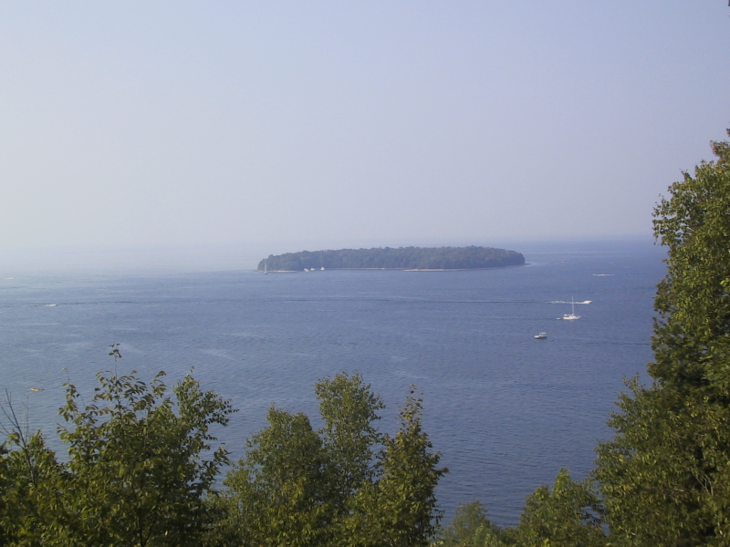
Newport is the outlier on this list in the best way. It’s Wisconsin’s only designated Dark Sky Park, which means light pollution is actively managed and the night sky here is genuinely impressive. The park is also one of the few in the state system with no drive-in camping — all sites are backpack-in or canoe-in, which keeps the crowds down considerably. It sits on the tip of the Door Peninsula with Lake Michigan on three sides, and the hiking trails along the shoreline are some of the quietest in Door County. If you’re looking for a state park experience that feels nothing like Devil’s Lake on a Saturday in July, Newport is the answer.
Complete Wisconsin State Parks List
Below are detailed notes on the full range of parks covered on this page. These run roughly alphabetically — use the quick-reference table above if you’re trying to compare parks side by side.
Amnicon Falls State Park
Amnicon Falls sits in the far northwestern corner of Wisconsin, not far from Superior, and it’s the kind of park that rewards the detour. The Amnicon River drops through a series of waterfalls — Upper, Lower, Snake Pit, and Now and Then Falls — over a short stretch, and a historic covered bridge crosses the river between two of them. The trail system is only about 1.8 miles total, so this isn’t a full-day hiking destination, but it’s an excellent stop if you’re driving the Lake Superior corridor. The 36-site campground is a solid base for exploring the area. The covered bridge alone is worth a photo stop.
Aztalan State Park
Aztalan is one of the more unusual stops in the Wisconsin state park system — it’s less about outdoor recreation and more about standing in a place where something genuinely significant happened. The site preserves the remains of a Mississippian culture settlement that thrived here between roughly 900 and 1200 CE. The earthwork mounds are still visible, and the interpretive signage does a decent job of explaining what archaeologists have pieced together about the community that built them. It was designated a National Historic Landmark in 1964. There’s no camping here, but it’s an easy day trip from Madison or Milwaukee and pairs well with a stop in nearby Lake Mills.
Belmont Mound State Park
Belmont Mound is a small, day-use-only park in Lafayette County that most people drive past without stopping. The 400-foot mound offers decent views of the surrounding Driftless landscape, and the park includes the First Capitol Historic Site — the building where Wisconsin’s first territorial legislature met in 1836. The observation tower has been closed for structural reasons; check the current DNR status before making it a primary destination. Good for a picnic and a history detour, not a full day out.
Big Bay State Park
Getting to Big Bay requires a ferry ride to Madeline Island, which is either a dealbreaker or half the fun depending on your travel style. The island is the only one of the 22 Apostle Islands that’s permanently inhabited, and Big Bay State Park takes up a good chunk of its eastern shore. The park has 1.5 miles of sandy Lake Superior beach, sandstone bluffs, a sphagnum bog, and old-growth forest — a lot of habitat variety for a relatively compact park. Bald eagles nest here annually. The campground has 60 sites. Plan the ferry crossing into your timing.
Big Foot Beach State Park
Big Foot Beach sits on the north shore of Geneva Lake in Walworth County, about 90 minutes from Chicago — which explains why it gets busy. The park is named for Ma-ka-tai-me-she-kia-kiak (Black Hawk), a Sauk leader also known as Big Foot, who was an early Potawatomi leader in the region. Geneva Lake itself is one of the clearest lakes in Wisconsin, and the swimming here is good. The campground has 100 sites. It’s a solid choice for a weekend trip from the Chicago or Milwaukee area, though summer weekends get crowded.
Blue Mound State Park
Blue Mound sits on the highest point in southern Wisconsin — about 1,716 feet — near the village of Blue Mounds in Dane County. On a clear day from the observation towers, you can see the Baraboo Range to the north and Madison to the east. The park has a swimming pool (open summers), a nature center with natural history exhibits, and a trail network that connects to the Military Ridge State Trail for longer bike rides. It’s a good base for exploring the Driftless Area and pairs naturally with a stop at nearby Cave of the Mounds.
Brunet Island State Park
Brunet Island occupies a 169-acre island in the Chippewa River near Cornell in Chippewa County, with additional acreage on the east bank. The park is known for its eastern hemlock trees — some of the largest in Wisconsin — and for reliable white-tailed deer sightings. The Old Abe State Trail starts here and runs south to Chippewa Falls, connecting to Lake Wissota State Park along the way. Good choice if you’re biking the trail system or looking for a quieter northern Wisconsin campground.
Buckhorn State Park
Buckhorn sits on a peninsula on Castle Rock Lake — a reservoir formed where the Wisconsin and Yellow Rivers meet — southeast of Necedah. At nearly 7,000 acres, it’s a substantial park with a lot of water access: boating, fishing, and swimming are the main draws. There are also hiking trails through the oak barrens and pine plantations that make up much of the park’s interior. Walk-in campsites are available and worth checking if the main campground is full. The area around Castle Rock Lake is good for spotting sandhill cranes in the fall.
Cadiz Springs State Recreation Area
Cadiz Springs is tucked into the Driftless Area of Green County, near Browntown, and it’s genuinely off the radar for most Wisconsin visitors. The recreation area centers on two spring-fed reservoirs — Beckman and Zander Lakes — totaling about 95 acres of surface water. Fishing, swimming, and non-motorized boating are the main activities. The surrounding land was combined with the Browntown Wildlife Area in 1980, so the whole property has a wilder, less-manicured feel than some of the more developed state parks. Worth knowing about if you’re exploring the Driftless and want to avoid the crowds at Governor Dodge.
Capital Springs State Recreation Area
Capital Springs sits on the southeast edge of Madison, straddling Lake Farm Road near Lake Waubesa. It’s primarily a local recreation area — paved trails, fishing access, and a disc golf course — rather than a destination park. That said, it’s a useful stop if you’re in Madison and want a quick outdoor break. The wetland areas along the lake edge are good for birding, particularly in spring migration.
Chippewa Moraine State Recreation Area
The Chippewa Moraine is one of the better places in Wisconsin to understand what the last glaciation actually looked like on the ground. The landscape here — kettles, kames, and moraines left by the retreating ice sheet — is unusually well-preserved, and the Ice Age National Scenic Trail runs through the property. The interpretive center does a good job explaining the geology. Hiking and cross-country skiing are the main activities. It’s part of the broader Ice Age National Scientific Reserve, which connects several Wisconsin sites along the terminal moraine.
Copper Culture State Park
Copper Culture is a small, day-use park in Oconto County that preserves the site of a burial ground used by Old Copper Complex people roughly 4,000 to 7,000 years ago — one of the oldest known copper-using cultures in North America. The park itself is modest, but the historical significance is real. It’s worth a stop if you’re in the Green Bay area and interested in pre-contact Wisconsin history.
Copper Falls State Park
Copper Falls is one of the best waterfall parks in Wisconsin and doesn’t get nearly the attention it deserves. The Bad River and Tyler Forks River have carved a deep gorge through ancient lava flows, creating a series of dramatic falls — Copper Falls, Brownstone Falls, and others — that you can view from a well-maintained trail loop of about 2 miles. The gorge walls are genuinely impressive. The campground has 55 sites. It’s in Ashland County, which puts it in the northern tier — a good anchor stop for a Lake Superior road trip.
Council Grounds State Park
Council Grounds is on the Wisconsin River near Merrill in Lincoln County. The park takes its name from the council grounds where Ojibwe and other nations met historically. Today it’s primarily a camping and water recreation park — the Wisconsin River frontage is the main draw, with good fishing and canoe access. The campground has over 50 sites. It’s a solid northern Wisconsin base camp without the crowds of the more famous parks.
Cross Plains State Park
Cross Plains is a small, undeveloped property in Dane County that most people don’t know exists. It’s essentially a natural area — oak savanna and prairie remnants — with limited facilities. The Ice Age Trail passes through. Good for a quiet walk, not a destination trip.
Devil’s Lake State Park
See the featured section above for full detail. Devil’s Lake is Wisconsin’s most-visited state park and the anchor of any Baraboo-area trip. The quartzite bluffs, the glacial lake, and the trail network make it genuinely worth the hype — just plan ahead for camping and expect company on summer weekends.
Fischer Creek State Recreation Area
Fischer Creek is a small Lake Michigan shoreline property in Manitowoc County. It’s primarily a natural area with beach access and some trail walking — not a full-featured park. Worth a stop if you’re driving the Lake Michigan coast, but not a standalone destination.
Governor Dodge State Park
Governor Dodge is the largest state park in southern Wisconsin at about 5,000 acres, and it earns that size. The park has two lakes, over 40 miles of trails for hiking and mountain biking, a horse trail system, and a campground with more than 260 sites. In winter, the trails convert to snowmobile and cross-country ski use. It’s in Iowa County near Dodgeville, which puts it in the heart of the Driftless Area — the surrounding landscape of ridges and coulees is part of the appeal. A genuinely versatile park for multiple seasons.
Governor Nelson State Park
Governor Nelson sits on the north shore of Lake Mendota, just outside Madison. It’s primarily a day-use park — swimming, fishing, and a boat launch — with some hiking trails through oak savanna. The effigy mounds on the property are worth seeking out. Good for a Madison-area afternoon, not a destination camping trip.
Governor Thompson State Park
Governor Thompson is in Marinette County in the northeast, centered on Caldron Falls Reservoir on the Peshtigo River. The park has good fishing and boating access, a campground, and trails through northern hardwood forest. It’s one of the less-visited parks in the system, which means easier reservations. The Peshtigo River corridor is worth exploring if you’re in the area — the river has significant whitewater sections downstream.
Harrington Beach State Park
Harrington Beach is on Lake Michigan in Ozaukee County, about 30 miles north of Milwaukee. The park has a mile of Lake Michigan shoreline, a small inland lake (Quarry Lake, a former limestone quarry), and trails through second-growth forest. It’s a popular day trip from Milwaukee and the northern suburbs. The quarry lake is a distinctive feature — clear water, good for swimming on hot days.
Hartman Creek State Park
Hartman Creek is in Waupaca County, in the chain o’ lakes region of central Wisconsin. The park has four lakes with swimming, fishing, and canoe access, plus a trail network that connects to the Ice Age Trail. The campground has about 100 sites. It’s a good central Wisconsin base camp — quieter than the Dells-area parks but with solid water access.
Heritage Hill State Historical Park
Heritage Hill in Green Bay is a living history museum rather than a natural area — it preserves and interprets historic buildings from Wisconsin’s past, including a fur trade era building, a Belgian farm, and a small-town main street. It’s run as a state historical park and charges separate admission. Worth visiting if you’re in Green Bay with kids or an interest in Wisconsin history, but it’s a different experience from the natural-area parks on this list.
High Cliff State Park
High Cliff sits on the eastern shore of Lake Winnebago — the largest inland lake in Wisconsin — in Calumet County. The park takes its name from the Niagara Escarpment, the same limestone ridge that creates Niagara Falls in New York. The views over Lake Winnebago from the bluff trail are legitimately good. The park also has effigy mounds, a marina, and a campground with about 100 sites. It’s a solid choice for eastern Wisconsin and often overlooked in favor of the Dells-area parks.
Hoffman Hills State Recreation Area
Hoffman Hills is a quiet, hilly property in Dunn County near Colfax. The observation tower here offers views over the surrounding morainic landscape — rolling hills, wetlands, and forest. It’s primarily a hiking and cross-country skiing area with no camping. A good stop if you’re in the Eau Claire area and want a short hike with a payoff view.
Kinnickinnic State Park
Kinnickinnic is where the Kinnickinnic River meets the St. Croix River in Pierce County, and the river delta here is one of the more unusual natural features in the state park system. The Kinnickinnic is a cold, spring-fed trout stream — one of the best in Wisconsin — and the delta it forms at the St. Croix is a rare geological feature. Day use only, no camping. The swimming area at the river mouth is popular on summer weekends. If you’re a trout angler, the stretch of the Kinni above the park is worth knowing about.
Kohler-Andrae State Park
Kohler-Andrae is on Lake Michigan in Sheboygan County, and it’s one of the better Lake Michigan shoreline parks in the state system. The park has about 2.5 miles of Lake Michigan beach, a dune cordwalk trail through the foredune, and a nature center. The campground has nearly 100 sites, some with good dune and lake views. It’s close to the village of Kohler and the American Club resort area if you want to mix state park camping with a nicer dinner. Book early for summer weekends — this one fills up.
Lake Kegonsa State Park
Lake Kegonsa is on the southernmost of Madison’s chain of lakes, in Dane County. It’s primarily a local recreation park — swimming, fishing, and camping — rather than a scenic destination. The campground has about 80 sites. Good for a Madison-area camping trip without driving far, but the park itself is fairly flat and unremarkable compared to the Driftless parks to the west.
Lake Wissota State Park
Lake Wissota is a reservoir park in Chippewa County, near Chippewa Falls. The park has good fishing and boating access on the reservoir, a campground with about 80 sites, and trails through mixed forest. It connects to the Old Abe State Trail, which runs north to Brunet Island State Park. A solid northern Wisconsin camping option, especially if you’re also planning to visit Chippewa Falls or Eau Claire.
Lakeshore State Park
Lakeshore State Park is in Milwaukee, on a man-made peninsula in Lake Michigan adjacent to the Henry Maier Festival Park (Summerfest grounds). It’s an urban park — paved trails, lake views, and a boat launch — rather than a wilderness experience. Worth a walk if you’re in Milwaukee, particularly for the skyline views back toward the city.
Lizard Mound State Park
Lizard Mound is a small, day-use park in Washington County that preserves a remarkable collection of effigy mounds — animal-shaped earthworks built by Late Woodland people between roughly 700 and 1100 CE. The mounds include lizard, panther, bird, and linear forms. A short loop trail winds through the mound group with interpretive signs. It’s a genuinely interesting stop if you’re interested in Wisconsin’s pre-contact history, and it’s easy to combine with a visit to nearby Kettle Moraine State Forest.
Menominee River State Park and Recreation Area
The Menominee River forms the border between Wisconsin and Michigan’s Upper Peninsula, and this park and recreation area runs along a stretch of the river in Marinette County. The river has significant whitewater sections, and the park provides access for fishing, kayaking, and hiking along the gorge. It’s a less-developed property — more of a natural corridor than a full-service park — but the river scenery is worth it if you’re in the area.
Merrick State Park
Merrick is on the Mississippi River in Buffalo County, near Fountain City. The park sits on a backwater area of the river — good for fishing, wildlife watching, and boating. The Mississippi River bluffs in this stretch are dramatic, and the park is a good base for exploring the Great River Road. The campground has about 60 sites. Bald eagles are common along this stretch of the river, especially in winter.
Mill Bluff State Park
Mill Bluff is one of the more visually striking parks in central Wisconsin. The park preserves a series of isolated sandstone mesas — remnants of islands that stood above Glacial Lake Wisconsin when the region was flooded by meltwater. The bluffs rise sharply from the surrounding flat plain, and a staircase trail climbs to the top of the main bluff for views over the landscape. It’s a day-use park with a swimming area. Easy to combine with a stop at nearby Necedah National Wildlife Refuge.
Mirror Lake State Park
Mirror Lake is in Sauk County, just a few miles from Wisconsin Dells, and it’s a genuinely good park that often gets overlooked because of its proximity to the Dells waterpark scene. The lake is calm and reflective — the name is accurate — and the sandstone bluffs around it are photogenic. Canoeing and kayaking are the best ways to see the park. The campground has about 150 sites across several loops. It’s a good alternative base if Devil’s Lake is fully booked — similar Baraboo-area geology, fewer crowds.
Natural Bridge State Park
Natural Bridge is a tiny park in Sauk County that exists essentially to protect one thing: a natural sandstone arch that’s the largest natural arch in Wisconsin, with a span of about 35 feet and a clearance of 25 feet. The hike to the arch is short — under a mile round trip. It’s a day-use-only park with no camping. Worth a stop if you’re already in the Baraboo/Dells area, but not worth a long detour on its own.
Nelson Dewey State Park
Nelson Dewey is in Grant County on the Mississippi River bluffs near Cassville — the southwestern corner of Wisconsin. The park is named for Wisconsin’s first governor, and the adjacent Stonefield historic site (operated separately) preserves his estate. The bluff views over the Mississippi are excellent, and the park has a campground with about 40 sites. It’s a good anchor for a Great River Road trip through southwestern Wisconsin.
New Glarus Woods State Park
New Glarus Woods is a small, wooded park just outside the village of New Glarus in Green County — the self-described “Little Switzerland of America.” The park has a campground with about 30 sites and a trail network through second-growth forest. It’s primarily useful as a base for visiting New Glarus itself — the village has good Swiss-themed restaurants, a well-regarded brewery (New Glarus Brewing), and some genuinely charming architecture. The park is quiet and unhurried, which fits the town’s pace.
Newport State Park
See the featured section above for full detail. Newport is Wisconsin’s only Dark Sky Park and one of the few state parks in the system with exclusively backpack-in and canoe-in camping. It’s on the tip of the Door Peninsula with Lake Michigan on three sides. If you want solitude and stars, this is the park.
More Wisconsin State Parks
The parks above cover the most-visited and most-searched properties in the Wisconsin state park system, but the DNR manages 66 parks, forests, and recreation areas in total. Some worth knowing about that aren’t covered in detail here:
- Pattison State Park (Douglas County) — home to Big Manitou Falls, the highest waterfall in Wisconsin at 165 feet
- Rib Mountain State Park (Marathon County) — one of the oldest rock formations in the world, good hiking and skiing near Wausau
- Interstate State Park (Polk County) — dramatic St. Croix River potholes and gorge, shared with Minnesota
- Wyalusing State Park (Grant County) — confluence of the Wisconsin and Mississippi Rivers, outstanding bluff views
- Peninsula State Park — see the featured section above
For the complete list of all Wisconsin state parks and recreation areas, the Wisconsin DNR’s Find a Park tool lets you filter by activity, region, and amenities.
Wisconsin State Parks: Frequently Asked Questions
Do you need a reservation to camp in Wisconsin state parks?
Most campgrounds in Wisconsin state parks require reservations, especially for summer weekends. You can book through wisconsin.goingtocamp.com. Some parks have a small number of first-come, first-served sites, but don’t count on them at popular parks like Devil’s Lake or Peninsula. Reservations typically open up to 11 months in advance.
What is the Wisconsin State Parks annual pass?
The annual vehicle admission sticker covers day-use entry to all Wisconsin state parks for one vehicle for a full year. It’s available for purchase at park offices or through the DNR website. Camping fees are separate and paid when you make your reservation. Check the DNR website for current pricing — it’s updated periodically.
Which Wisconsin state parks are best for families with kids?
Governor Dodge, Mirror Lake, Hartman Creek, and Kohler-Andrae are all consistently good choices for families — they have swimming, manageable hiking, and well-maintained campgrounds. Devil’s Lake is great for older kids who can handle the bluff trails, but the crowds on summer weekends can be a lot. Newport State Park is worth considering for families who want a quieter, more adventurous experience.
Can you hike in Wisconsin state parks year-round?
Yes. Most Wisconsin state parks are open year-round, and many have groomed cross-country ski and snowshoe trails in winter. Governor Dodge, Devil’s Lake, and Blue Mound are among the parks with the best winter trail systems. Some facilities (nature centers, swimming areas) are seasonal.