Minnesota State Parks: Map, List, and What’s Worth the Drive
Minnesota has 75 state parks and recreation areas spread across a landscape that shifts from tallgrass prairie in the southwest to boreal forest along the Canadian border. That’s a lot of ground to cover — and a lot of decisions to make before you load up the car. This page gives you a map of Minnesota state parks, a full list organized for easy scanning, and enough detail on the standout parks to help you figure out where to actually go.
Whether you’re planning a weekend camping trip, looking to knock parks off a checklist, or just trying to figure out which parks are worth a detour on a longer drive, here’s what you need to know.
Quick Answers: Minnesota State Parks FAQs
- How many state parks does Minnesota have?
- Minnesota has 75 state parks and recreation areas managed by the Minnesota DNR. Itasca State Park, established in 1891, is the oldest — and still one of the most visited.
- What is the most beautiful state park in Minnesota?
- That’s a subjective call, but Gooseberry Falls, Cascade River, and Itasca State Park come up most consistently when people ask. For something more dramatic and less crowded, Judge C.R. Magney State Park on the North Shore is hard to beat — it’s where the Devil’s Kettle waterfall swallows half a river and nobody’s quite sure where it goes.
- Can seniors get into Minnesota state parks for free?
- Minnesota residents aged 65 and older can purchase a Senior Citizen Lifetime Vehicle Permit at a significantly reduced one-time fee (check the current rate at the Minnesota DNR website, as fees are updated periodically). It covers the vehicle permit fee for all state parks — a solid deal if you plan to visit more than once or twice a year.
- How do I make camping reservations at Minnesota state parks?
- Reservations are made through the Minnesota state parks reservation system at reservemn.usedirect.com. Fair warning: popular parks like Gooseberry Falls, Itasca, and Split Rock Lighthouse book up fast — sometimes within minutes of the reservation window opening for summer weekends. If you’re flexible on dates or willing to try weekdays, you’ll have much better luck.
- Does Minnesota have any national parks?
- Yes — Voyageurs National Park in northern Minnesota is the state’s only national park, covering over 218,000 acres of lakes and boreal forest near International Falls. It’s a water-based park, meaning most of it is only accessible by boat. The state parks listed here are separate from Voyageurs and are managed by the Minnesota DNR.
Printable Minnesota State Parks Map
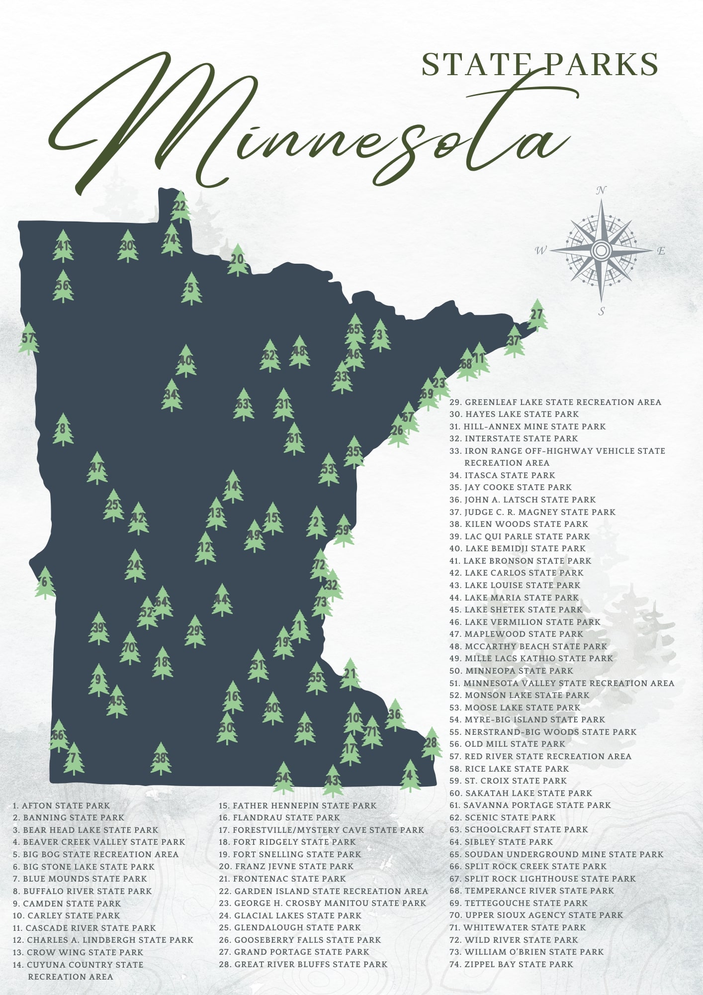
Full List of Minnesota State Parks and Recreation Areas
Minnesota’s 75 parks cover a lot of different terrain and a lot of different experiences. Here’s the full list organized alphabetically, with the region and one thing each park is particularly known for. Use it as a planning reference or a checklist — either works.
| Park / Recreation Area | Region | Known For |
|---|---|---|
| Afton State Park | Metro / St. Croix Valley | St. Croix River bluffs, backpack-in camping, no car access to beach |
| Banning State Park | East Central | Kettle River rapids (up to Class IV), sandstone potholes, state-record sturgeon water |
| Bear Head Lake State Park | Northeast / Iron Range | Four fishing lakes, Boundary Waters-adjacent feel, black bear sightings |
| Beaver Creek Valley State Park | Southeast / Driftless Area | Native brook trout stream, 250-foot forested valley, WPA-era development |
| Big Bog State Recreation Area | Northwest | Nearly 10,000 acres of bog and upland, rare bird habitat, boardwalk into the bog |
| Big Stone Lake State Park | Southwest | Headwaters of the Minnesota River, wildlife viewing, two separate park units |
| Blue Mounds State Park | Southwest | American bison herd, Sioux Quartzite cliffs, prairie remnant, rock climbing |
| Buffalo River State Park | Northwest / Red River Valley | One of Minnesota’s largest high-quality prairie remnants, river swimming |
| Camden State Park | Southwest | Redwood River valley, wooded ravines in open prairie country |
| Carley State Park | Southeast | Wild trout stream, spring wildflowers, small and quiet |
| Cascade River State Park | North Shore | Dramatic river cascades dropping to Lake Superior, Superior Hiking Trail access |
| Charles A. Lindbergh State Park | Central | Boyhood home of Charles Lindbergh, Pike Creek, Little Falls location |
| Crow Wing State Park | Central | Historic Crow Wing village site, Mississippi and Crow Wing river confluence |
| Cuyuna Country State Recreation Area | Central / Iron Range | World-class mountain biking on former iron ore mine terrain, crystal-clear mine pit lakes |
| Father Hennepin State Park | Central | Mille Lacs Lake access, swimming, fishing for walleye |
| Flandrau State Park | South Central | Sand-bottomed swimming pond, New Ulm location, Cottonwood River |
| Forestville/Mystery Cave State Park | Southeast / Driftless Area | Minnesota’s longest cave system, historic Forestville townsite, trout streams |
| Fort Ridgely State Park | South Central | Dakota War of 1862 history, golf course, Renville County |
| Fort Snelling State Park | Metro | Mississippi and Minnesota river confluence, Pike Island, urban access |
| Franz Jevne State Park | North / Rainy River | Small and remote, Rainy River frontage, one of the least-visited parks in the system |
| Frontenac State Park | Southeast / Mississippi River | Mississippi River bluffs, exceptional birding (over 260 species recorded) |
| Garden Island State Recreation Area | Northwest / Lake of the Woods | Boat-access only island in Lake of the Woods, primitive camping |
| George H. Crosby Manitou State Park | North Shore | Backcountry-only camping, rugged Manitou River gorge, no drive-in sites |
| Glacial Lakes State Park | West Central | Rolling glacial terrain, prairie and oak savanna, horse camping |
| Glendalough State Park | West Central | Heritage fishing (special regulations), quiet lakes, former private retreat |
| Gooseberry Falls State Park | North Shore | Five waterfalls, Lake Superior access, one of the most visited parks in MN |
| Grand Portage State Park | North Shore / Canadian Border | Minnesota’s highest waterfall (High Falls of the Pigeon River), tribal partnership |
| Great River Bluffs State Park | Southeast / Mississippi River | Dramatic bluff-top views of the Mississippi, goat prairies, Winona County |
| Greenleaf Lake State Recreation Area | Central | Small, quiet, good for fishing and paddling |
| Hayes Lake State Park | Northwest | Bog boardwalk, northern forest feel, Roseau County |
| Hill-Annex Mine State Park | Northeast / Iron Range | Open-pit iron ore mine tours, fossil hunting, Calumet |
| Interstate State Park | East / St. Croix River | Glacial potholes, St. Croix River, rock climbing, Taylor’s Falls |
| Iron Range Off-Highway Vehicle State Recreation Area | Northeast / Iron Range | OHV trails on reclaimed mine land near Gilbert |
| Itasca State Park | Northwest / Headwaters | Mississippi River headwaters, Minnesota’s oldest park (1891), old-growth forest |
| Jay Cooke State Park | Northeast / Duluth Area | Swinging bridge over the St. Louis River, Superior Hiking Trail, rugged terrain |
| John A. Latsch State Park | Southeast / Mississippi River | Three bluffs with river views, day-use only, Winona County |
| Judge C.R. Magney State Park | North Shore | Devil’s Kettle waterfall (half the river disappears underground), remote feel |
| Kilen Woods State Park | Southwest | Des Moines River valley, wooded ravines in prairie country |
| Lac qui Parle State Park | Southwest | Waterfowl migration, Lac qui Parle Wildlife Management Area adjacency |
| Lake Bemidji State Park | North Central | Bog boardwalk, lake swimming, old-growth forest near Bemidji |
| Lake Bronson State Park | Northwest | Swimming lake, observation tower, one of the northwesternmost parks in MN |
| Lake Carlos State Park | West Central | Clear lake swimming, horse camping, Alexandria lakes area |
| Lake Louise State Park | Southeast | Trout fishing, quiet trails, Iowa border country |
| Lake Maria State Park | Metro / West | Backpack-in camping only, prairie and forest mix, good for wildlife |
| Lake Shetek State Park | Southwest | Largest lake in southwest MN, pelicans, open prairie setting |
| Lake Vermilion-Soudan State Park | Northeast / Iron Range | Underground mine tours, Lake Vermilion access, physics lab deep underground |
| Maplewood State Park | West Central | Glacial lakes and hills, horse camping, Pelican Rapids area |
| McCarthy Beach State Park | Northeast / Iron Range | Sandy beach on Sturgeon Lake, Iron Range location |
| Mille Lacs Kathio State Park | Central | 9,000 years of human history, observation tower, Rum River headwaters |
| Minneopa State Park | South Central | Bison herd, two-step waterfall, Mankato area |
| Minnesota Valley State Recreation Area | Metro / South | Minnesota River corridor, wildlife refuge adjacency, urban access |
| Monson Lake State Park | West Central | Small and quiet, Dakota War of 1862 memorial, Sunburg area |
| Moose Lake State Park | East Central | Agate hunting, lake swimming, I-35 corridor stop |
| Myre-Big Island State Park | Southeast | Albert Lea Lake, birding, island camping |
| Nerstrand-Big Woods State Park | Southeast | Last significant remnant of the Big Woods forest, Hidden Falls, spring wildflowers |
| Old Mill State Park | Northwest | Historic grist mill, Middle River, small and uncrowded |
| Red River State Recreation Area | Northwest / Red River Valley | Red River frontage, East Grand Forks, urban park feel |
| Rice Lake State Park | Southeast | Waterfowl staging area, quiet lake, Owatonna area |
| St. Croix State Park | East / St. Croix River | Minnesota’s largest state park, river frontage, horse and canoe camping |
| Sakatah Lake State Park | South Central | Sakatah Singing Hills State Trail, lake camping, Waterville area |
| Savanna Portage State Park | Northeast / Iron Range | Historic fur trade portage route, remote lakes, bog hiking |
| Scenic State Park | Northeast | Old-growth pine, two clear lakes, Bigfork area |
| Schoolcraft State Park | North Central | Mississippi River, remote and quiet, Deer River area |
| Sibley State Park | West Central | Lake Andrew swimming, observation tower, New London area |
| Split Rock Creek State Park | Southwest | Pipestone County, reservoir swimming, prairie setting |
| Split Rock Lighthouse State Park | North Shore | Iconic lighthouse, Lake Superior pebble beach, history programs — one of MN’s most photographed spots |
| Temperance River State Park | North Shore | Narrow gorge, Lake Superior access, Superior Hiking Trail |
| Tettegouche State Park | North Shore | Inland lakes, waterfalls, Lake Superior cliffs, one of the best all-around North Shore parks |
| Upper Sioux Agency State Park | Southwest | Minnesota River valley, Dakota history, Yellow Medicine County |
| Whitewater State Park | Southeast / Driftless Area | Whitewater River, limestone bluffs, trout fishing, wildflowers |
| Wild River State Park | East / St. Croix River | St. Croix River, canoe camping, 35 miles of trails |
| William O’Brien State Park | East / St. Croix River | St. Croix River, lake swimming, close to the Twin Cities |
| Zippel Bay State Park | Northwest / Lake of the Woods | Lake of the Woods beach, walleye fishing, remote northwest corner |
Note: A small number of parks near the bottom of this list use plain text rather than links because their DNR URLs were not confirmed in our source inventory at time of publication. Links will be added as they are verified. For the complete official list, visit the Minnesota DNR state parks page.
Parks Worth Calling Out
The full list above covers all 75 parks, but a few deserve more than a table row. Here are the ones that come up most often when people are actually planning a trip — and a couple of underrated picks that don’t get enough attention.
Itasca State Park
Minnesota’s oldest state park and still one of its best. Itasca was established in 1891 to protect the headwaters of the Mississippi River — and you can actually walk across the river here on stepping stones, which is a strange and satisfying thing to do given that the same water eventually reaches the Gulf of Mexico. The park covers over 32,000 acres of old-growth forest, and the drive through it on the park road is worth doing even if you’re not camping. There’s a lodge, cabins, and a full campground, but book early — this one fills up.

Gooseberry Falls State Park
Five waterfalls, Lake Superior access, and a visitor center right off Highway 61 — Gooseberry is the most visited state park on the North Shore for good reason. It’s easy to get to, the falls are genuinely impressive, and the Lake Superior shoreline here is all rocky shelves and cold water. The downside: it gets crowded on summer weekends, and campsites book up fast. If you’re flexible, a weekday visit in September hits the sweet spot — the falls are running well and the crowds thin out considerably.
Cascade River State Park
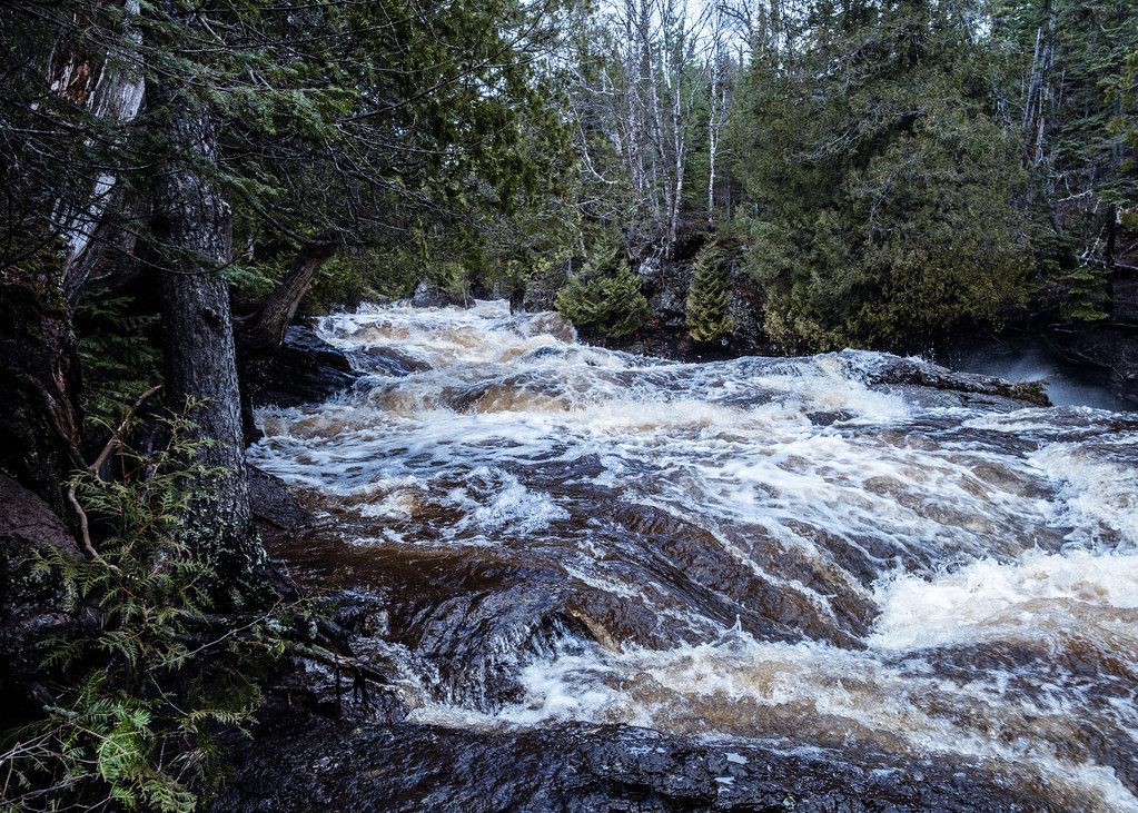
Cascade River is one of the North Shore parks that rewards the extra drive past Gooseberry. The river drops through a series of cascades and gorges before hitting Lake Superior, and the hiking here is more rugged than the well-worn paths at Gooseberry. The Superior Hiking Trail passes through, so it’s a good staging point if you’re doing a longer stretch of the trail. Camping is available but the park stays less crowded than its neighbors to the south.
Judge C.R. Magney State Park
This one’s for people who like a little mystery with their hiking. The Brule River splits at Devil’s Kettle — one half goes over a conventional waterfall, the other half drops into a pothole and disappears. Nobody has conclusively proven where it goes. Scientists have tried dye, ping-pong balls, and GPS trackers. The park is remote (it’s near Grand Marais, close to the Canadian border), the trail to the falls is a real hike, and the whole place feels less polished than the bigger North Shore parks. That’s the appeal.
Blue Mounds State Park

Most people driving across southern Minnesota on I-90 skip this one, which is a mistake. Blue Mounds sits near Luverne in Rock County and protects one of the largest remaining prairie remnants in the state. There’s a bison herd, a cliff of Precambrian Sioux Quartzite that turns blue-gray in the distance, and a small reservoir for swimming. The interpretive center was once the home of novelist Frederick Manfred. It’s a genuinely different landscape from the rest of Minnesota — flat, open, and big-sky in a way that feels more like South Dakota than the north woods.
Cuyuna Country State Recreation Area
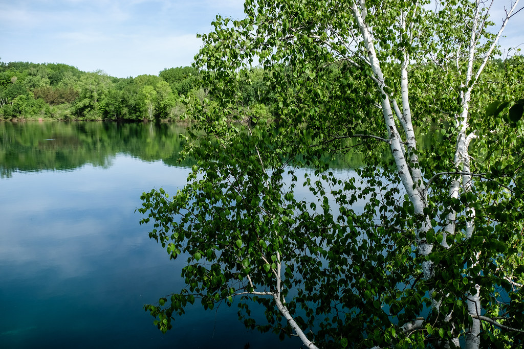
Cuyuna is the park that surprises people. The Iron Range left behind a landscape of open-pit mines that have since filled with water so clear it looks Caribbean blue in photos — and it actually looks like that in person too. The mountain biking trails here are legitimately world-class, drawing riders from across the Midwest. If you’re not a biker, the mine lakes are worth seeing on their own. The town of Crosby is right there and has a decent food scene for a small Iron Range town.
George H. Crosby Manitou State Park
If you want the most backcountry experience available in the Minnesota state park system, Crosby Manitou is it. There are no drive-in campsites — every campsite requires a hike in, and the Manitou River gorge is rugged enough that this park stays quiet even when the rest of the North Shore is packed. It’s not a beginner park, but for anyone who wants to feel genuinely away from things, it delivers.
Banning State Park

Banning sits along the Kettle River, which was the first river in Minnesota to receive Wild and Scenic designation. The 1.5-mile stretch of rapids here runs up to Class IV, and the sandstone potholes and rock formations along the riverbank are worth exploring even if you’re not paddling. Wolf Creek Falls and Robinson Ice Cave add to the list of reasons to stop. It’s a good park to pair with a drive up Highway 61 if you’re heading toward Duluth.
Forestville/Mystery Cave State Park
Two parks in one, essentially. Forestville is a preserved 19th-century townsite where the DNR runs living history programs — it’s one of the more unusual things you can do in a Minnesota state park. Mystery Cave is Minnesota’s longest cave system, with guided tours running through passages filled with fossils, pools, and formations. The park sits in the Driftless Area of southeastern Minnesota, which means the terrain is all limestone bluffs and spring-fed trout streams rather than the glacial lakes you find most everywhere else in the state.
Planning Tips for Minnesota State Parks
Reservations
Most Minnesota state park campsites can be reserved through the Minnesota state parks reservation system. Reservations open on a rolling window, and the most popular parks — Gooseberry Falls, Itasca, Split Rock Lighthouse, Tettegouche — fill up fast for summer weekends. If you’re planning a summer trip to a North Shore park, check the reservation calendar as early as possible. Weekdays and shoulder season (May, September, October) are significantly easier to book.
Vehicle Permits
You need a Minnesota State Parks vehicle permit to enter any state park. Day permits and annual passes are available at park offices or online through the DNR. If you’re visiting more than two or three parks in a year, the annual pass pays for itself quickly. Minnesota residents 65 and older can purchase a Senior Citizen Lifetime Vehicle Permit at a reduced one-time cost — check the current fee on the DNR website.
What to Expect by Region
- North Shore (Highway 61 corridor): Waterfalls, Lake Superior access, Superior Hiking Trail. Most dramatic scenery in the system. Also the most crowded in summer.
- Northeast / Iron Range: Mine history, clear lakes, boreal forest. Cuyuna for biking, Bear Head Lake for a quieter Boundary Waters feel, Lake Vermilion-Soudan for underground mine tours.
- Southeast / Driftless Area: Limestone bluffs, trout streams, caves. Completely different landscape from the rest of Minnesota — no glacial lakes, lots of spring-fed creeks.
- Southwest: Prairie, bison, big sky. Blue Mounds and Minneopa both have bison herds. Less visited than the north, which means easier reservations.
- Metro area: Fort Snelling, Afton, William O’Brien, and Minnesota Valley SRA are all within reasonable distance of the Twin Cities and good for day trips.
Individual Park Guides
Below are more detailed notes on the parks covered in the original guide. For the full list with quick-reference details, see the table above.
Afton State Park

Afton is the kind of park that surprises people who expect something tame because it’s close to the city. The St. Croix River bluffs here are steep and the views are legitimately good. There’s no vehicle access to the camping area or the swimming beach — you hike in, which keeps it quieter than you’d expect for a park this close to St. Paul. The campground has 28 backpacking sites and four camper cabins with electricity. Over 20 miles of trails cover the glacial moraine terrain, and some are open to horses and cross-country skiing in winter.
Bear Head Lake State Park
Bear Head Lake is near Ely in Saint Louis County, which puts it close to the Boundary Waters Canoe Area Wilderness without requiring a permit or a canoe shuttle. The park has four fishing lakes, including the 670-acre Bear Head Lake, and the surrounding 5,540 acres of woodland give it a genuinely remote feel. Camping options include drive-in sites, a guesthouse rental, and backpacking. The park has a reputation for black bear sightings — the kind of thing that’s exciting rather than alarming when you’re actually there.
Beaver Creek Valley State Park
Beaver Creek Valley is in the Driftless Area near Caledonia in Houston County — the part of Minnesota that glaciers missed, which means the terrain is all carved limestone valleys and spring-fed streams rather than lakes. East Beaver Creek runs through a valley up to 250 feet deep, and the stream holds native brook trout and introduced brown trout. The park was developed in the 1930s by the Works Progress Administration, and the stonework from that era is still visible. Camping options include 42 drive-in sites (16 with electrical hookups), six walk-in sites, a camper cabin, and three group sites. Eight miles of hiking trails.
Big Bog State Recreation Area
Big Bog is one of the more unusual parks in the system. It covers nearly 10,000 acres of peatland, bog, and upland forest near Waskish in Beltrami County, just off Highway 72. The park opened in 2006 after local community efforts to protect the area, and it’s become a destination for birders and people who want to see what a real northern Minnesota bog looks like up close. There’s a boardwalk that extends into the bog itself, which is the right way to experience it — the peat is deep enough that walking off-trail is not a good idea.
Big Stone Lake State Park

Big Stone Lake sits on the South Dakota border near Ortonville and marks the headwaters of the Minnesota River. The park is split into two units — the Bonanza Area in the north and the Meadowbrook Area in the south — about 12 miles apart. Wildlife here includes deer, raccoons, meadowlarks, pheasants, and wild turkeys. It’s a quieter park that doesn’t get much attention, which means you’ll generally have the picnic areas and hiking trails to yourself.
Buffalo River State Park

Buffalo River is just off U.S. Route 10 in Clay County, near Moorhead. The 1,068-acre park protects one of the largest high-quality prairie remnants in Minnesota, which is worth stopping for even if you’re just passing through on the way to or from Fargo. The Buffalo River itself is good for swimming and fishing. The campground has 44 sites with showers, flush toilets, and a dump station. The park also runs educational programming that’s well-regarded.
Camden State Park
Camden is in southwestern Minnesota near Marshall, tucked into the Redwood River valley in a part of the state that’s mostly open farmland. The wooded ravines here feel like a surprise — you’re driving through flat prairie and then suddenly there’s a forested valley with a river running through it. The park has been a local favorite since the 1930s and offers camping, hiking, and picnicking. It’s a good stop on a longer drive through the southwest corner of the state.
Carley State Park

Carley is one of the smaller and quieter parks in the system, sitting along the North Branch of the Whitewater River in Winona County. It’s a good spring destination — the wildflower display here is genuinely impressive, and the trout fishing in the stream is a draw for anglers. If you’re already visiting Whitewater State Park nearby, Carley is worth adding to the itinerary.
Charles A. Lindbergh State Park

This park in Little Falls preserves the boyhood home of Charles Lindbergh, who grew up here before his 1927 solo transatlantic flight. The house is managed as a historic site, and the park itself sits along Pike Creek where it meets the Mississippi River. It’s a combination of history and outdoor recreation that works well — you can tour the house and then hike the trails along the river. Little Falls is a pleasant small town worth a stop on its own.
Crow Wing State Park

Crow Wing sits at the confluence of the Crow Wing and Mississippi rivers, south of Brainerd. The park preserves the site of the historic Crow Wing village, which was an important fur trade and missionary settlement in the 19th century before being abandoned when the railroad bypassed it. The river confluence is the geographic draw — it’s a good spot to paddle if you have a canoe or kayak, and the trails along the riverbank are easy and scenic.
Father Hennepin State Park
Father Hennepin sits on the south shore of Mille Lacs Lake, one of Minnesota’s largest and most famous walleye lakes. The park is a good base for fishing, swimming, and exploring the Mille Lacs area. Mille Lacs Kathio State Park is nearby and adds a deeper historical dimension — the two parks together make a good two-day trip from the Twin Cities.
Flandrau State Park
Flandrau is in New Ulm, which is worth visiting on its own — it’s a German-heritage town with a distinctive character and a good downtown. The park sits along the Cottonwood River and has a sand-bottomed swimming pond that’s been a local favorite for decades. It’s a good family park: easy terrain, a campground with full amenities, and the town right there if you need a meal or a break from the outdoors.
Fort Snelling State Park
Fort Snelling sits at the confluence of the Mississippi and Minnesota rivers, within the Twin Cities metro. It’s one of the most historically significant spots in Minnesota — the confluence was a sacred site for Dakota people long before European settlement, and the fort itself dates to the 1820s. The state park covers the river bottoms and Pike Island, with trails, river access, and wildlife that’s surprisingly abundant given the urban surroundings. Historic Fort Snelling (managed separately) is adjacent and worth combining with a park visit.
Frontenac State Park
Frontenac sits on the Mississippi River bluffs in Goodhue County, near the small town of Old Frontenac. The birding here is exceptional — over 260 species have been recorded in the park, and it’s a well-known stop on the Mississippi Flyway migration route. The bluff-top views of the river are among the best in the state. It’s a quieter park that doesn’t get the attention it deserves.
Grand Portage State Park
Grand Portage is at the very northeastern tip of Minnesota, right on the Canadian border near the Grand Portage Ojibwe Nation. The park is home to the High Falls of the Pigeon River — at 120 feet, it’s the highest waterfall in Minnesota. The trail to the falls is accessible and well-maintained. The park is managed in partnership with the Grand Portage Band of Lake Superior Chippewa, which gives it a distinctive character. If you’re driving the full length of Highway 61, this is the end of the road.
Hill-Annex Mine State Park
Hill-Annex is an open-pit iron ore mine near Calumet on the Iron Range that operated from 1913 to 1978. The DNR now runs guided tours of the pit, and the site has become a destination for fossil hunters — marine fossils from the Cretaceous period are found in the rock layers exposed by the mining. It’s a genuinely interesting stop if you’re driving through the Iron Range and want something different from the usual forest-and-lake parks.
Interstate State Park
Interstate sits on both sides of the St. Croix River at Taylor’s Falls — the Minnesota side is the state park, and Wisconsin has its own Interstate State Park on the other bank. The main draw is the glacial potholes, which are among the deepest in the world and were carved by meltwater during the last ice age. Rock climbing is popular on the basalt cliffs. The town of Taylor’s Falls has a good main street and is a reasonable day trip from the Twin Cities.
Jay Cooke State Park
Jay Cooke is southwest of Duluth along the St. Louis River, and it’s one of the more dramatic parks in the system. The river runs through a series of slate rock formations that create a turbulent, churning stretch of water, and the swinging bridge over the gorge is one of the more memorable spots in any Minnesota state park. The Superior Hiking Trail passes through, and the park has a full campground. It was significantly damaged by flooding in 2012 and has since been largely restored.
John A. Latsch State Park
Latsch is a small, day-use-only park in Winona County with three named bluffs — Faith, Hope, and Charity — that rise above the Mississippi River. The climb to the top is steep but short, and the views of the river valley from the bluffs are worth the effort. It’s a good stop on a drive along the Great River Road.
Kilen Woods State Park
Kilen Woods is in Jackson County in the southwest corner of Minnesota, tucked into the Des Moines River valley. The wooded ravines here are a genuine contrast to the surrounding farmland, and the park is quiet enough that you’ll likely have the trails to yourself. It’s a good stop if you’re driving through the southwest and want to stretch your legs somewhere with actual trees.
Lac qui Parle State Park
Lac qui Parle (French for “lake that speaks”) is in Chippewa County near Montevideo, adjacent to the Lac qui Parle Wildlife Management Area. The area is one of the best waterfowl staging areas in the state — during fall migration, the numbers of geese and ducks can be genuinely staggering. The park itself has camping and lake access, and it’s a good base for exploring the wildlife management area next door.